The best walks and hikes around Saint-Julien-Gaulène
4.6
(150)
936
hikers
32
hikes
Hiking trails around Saint-Julien-Gaulène traverse a landscape characterized by rolling hills, river valleys, and a mix of open countryside and woodland. The region offers varied terrain, from gentle paths along waterways to more elevated routes providing expansive views. The area is suitable for exploring the natural environment through a network of established paths.
Best hiking trails around Saint-Julien-Gaulène
- The most popular hiking route is Sentier de l'Andouquette – loop starting from Crespin, a 4.8 miles (7.7 km) trail that…
Last updated: July 8, 2026
4.8
(26)
162
hikers
10.2km
03:26
410m
410m
Moderate hike. Good fitness required. Mostly accessible paths. Sure-footedness required.
4.9
(16)
118
hikers
10.1km
03:21
440m
440m
Moderate hike. Good fitness required. Mostly accessible paths. Sure-footedness required.

Sign up for free
5.0
(2)
12
hikers
5.24km
01:31
110m
110m
Easy hike. Great for any fitness level. Easily-accessible paths. Suitable for all skill levels.
4.5
(2)
13
hikers
1.97km
00:37
70m
70m
Easy hike. Great for any fitness level. Easily-accessible paths. Suitable for all skill levels.
4.0
(1)
9
hikers
9.10km
02:40
250m
250m
Moderate hike. Good fitness required. Easily-accessible paths. Suitable for all skill levels.
Get access to more routes and recommendations from other explorers.
Sign up for free
Already have an account?
Our route recommendations are based on thousands of hikes, rides, and runs completed by other people on komoot.
Start today with a free account
Your next adventure awaits.
Login or Signup


Tips from the Community

The Priory of Ambialet is no longer occupied by a religious community, but it houses the Oder Café, where you can drink a coffee while enjoying a delicious homemade pastry.
0
0


The devil is in the detail, but the view makes up for everything!
0
0

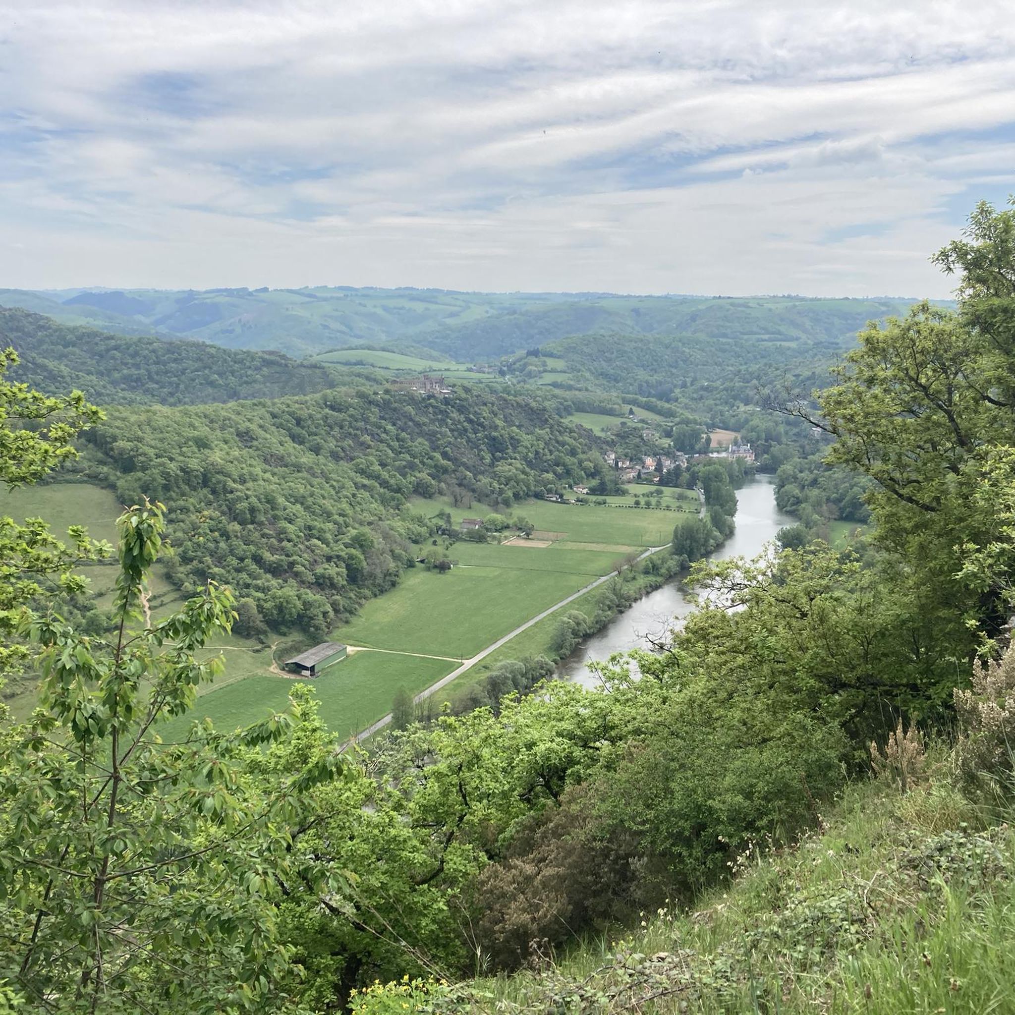
Superb view of Ambialet and its peninsula, created naturally by a meander of the Tarn, which embraces it for three kilometers. It is dominated by an old priory, perched on a shale ridge. At the level of the dam, the narrowest isthmus in Europe is located!
1
0
The Tarn valley is steep enough that leaving it involves a nice climb, 5 to 6 km with passages at 10%. And multiple routes around Ambialet.
1
0

As you come down the D74 road and around the last corner before entering town, you get a splendid view of the village of Ambialet and the old hilltop Cathar fortress. Both look as if they have naturally emerged from the local rock-bed over the past few centuries. There is one restaurant and two cafes in town as well as a cafe and small hotel just over the bridge on the other side of town.
0
0

If the peninsulas formed by meanders are relatively common, here the isthmus which prevents the Tarn from shooting straight is only about ten meters wide, which makes it the narrowest and most spectacular of Europe. It is a safe bet that in a few millennia, erosion will eventually lead the Tarn to cross it and thus abandon its arm, as is sometimes the case (cf. Cirque de Navacelle). This geological particularity was in any case exploited from the very beginning of the 1900s for the production of electricity with a factory with magnificent architecture that can be visited.
0
0
Frequently Asked Questions
How many hiking trails are available around Saint-Julien-Gaulène?
There are over 25 hiking routes in the Saint-Julien-Gaulène area, offering a variety of experiences from easy strolls to more challenging moderate hikes. The komoot community has explored these trails over 800 times.
Are there easy hiking trails suitable for beginners or families?
Yes, Saint-Julien-Gaulène offers 6 easy hiking routes perfect for beginners or families. An example is the Ambialet – Prieuré d'Ambialet loop from Ambialet, which is just under 3 miles (4.6 km) and features gentle elevation changes.
What kind of terrain can I expect on hikes in this region?
The terrain around Saint-Julien-Gaulène is characterized by rolling hills, picturesque river valleys, and a mix of open countryside and woodlands. You'll find well-established paths, some along waterways, and others offering elevated views of the landscape.
Are there any circular walks available?
Many of the trails in the area are circular, allowing you to start and end in the same location. Popular options include the Sentier de l'Andouquette – loop starting from Crespin and the Hiking loop from Ambialet.
What are some interesting landmarks or attractions to see while hiking?
The region is rich in natural and historical sights. Along your hikes, you might encounter the dramatic Ambialet Isthmus and Ambialet Hydroelectric Power Plant, the historic Prieuré d'Ambialet, or enjoy the scenic View of Ambialet. The L'Ambialade Heritage Trail specifically explores historical and natural points of interest.
Is Saint-Julien-Gaulène suitable for dog-friendly hiking?
Generally, the rural trails around Saint-Julien-Gaulène are welcoming for dogs, provided they are kept under control, especially near livestock or in populated areas. Always ensure to clean up after your pet.
What is the best time of year to go hiking in Saint-Julien-Gaulène?
Spring and autumn are ideal for hiking in Saint-Julien-Gaulène, offering pleasant temperatures and vibrant natural scenery. Summer can be warm, making early morning or late afternoon hikes preferable. Winter hiking is possible, but some paths might be muddy or less accessible depending on weather conditions.
Are there any hikes that offer particularly good views?
Many routes in the region provide expansive views, especially those that climb to higher points. The View of Ambialet – View of Ambialet loop from Ambialet is specifically designed to showcase the stunning panoramas of the area.
What do other hikers say about the trails in Saint-Julien-Gaulène?
The trails in Saint-Julien-Gaulène are highly regarded by the komoot community, with an average rating of 4.6 stars from over 130 reviews. Hikers often praise the varied terrain, the peaceful atmosphere, and the well-maintained paths that showcase the region's natural beauty.
Are there any opportunities for wild swimming near the hiking trails?
While the region features river valleys like the one carved by the Ruisseau de l'Andouquette, specific designated wild swimming spots are not explicitly highlighted. Always exercise caution and check local regulations if considering swimming in natural bodies of water.
How long do hikes typically take in Saint-Julien-Gaulène?
Hike durations vary depending on the route and your pace. For example, the Sentier de l'Andouquette – loop starting from Crespin typically takes around 2 hours 18 minutes, while the longer Hiking loop from Ambialet can take about 3 hours 26 minutes.
Most popular routes around Saint-Julien-Gaulène
Most popular attractions around Saint-Julien-Gaulène

Get inspired with the komoot mobile app


Explore more
Browse the best Hikes in other regions.
