The best walks and hikes around Saint-Sauveur-De-Meilhan
4.5
(17)
141
hikers
33
hikes
Hiking around Saint-Sauveur-De-Meilhan offers exploration of a rural landscape situated between the Garonne plain and gently rising hills. The terrain features extensive vineyards, sheep pastures, and significant woodlands. The Lisos river, a Natura 2000 site, borders the commune to the west, providing riparian forests and diverse habitats. This area offers varied views and hiking experiences across its transitional geography.
Best hiking trails around Saint-Sauveur-De-Meilhan
- The most popular hiking route is Ship birth on the canal – Aqueduct in Meilhan-sur-Garonne loop…
Last updated: July 23, 2026
14
hikers
Easy hike. Great for any fitness level. Easily-accessible paths. Suitable for all skill levels.
10
hikers
Moderate hike. Good fitness required. Easily-accessible paths. Suitable for all skill levels.

Sign up for free
4
hikers
3.50km
00:59
80m
80m
Easy hike. Great for any fitness level. Easily-accessible paths. Suitable for all skill levels.
9
hikers
4.00km
01:04
30m
30m
Easy hike. Great for any fitness level. Easily-accessible paths. Suitable for all skill levels.
9
hikers
10.2km
02:52
200m
200m
Moderate hike. Good fitness required. Easily-accessible paths. Suitable for all skill levels.
Get access to more routes and recommendations from other explorers.
Sign up for free
Already have an account?
Our route recommendations are based on thousands of hikes, rides, and runs completed by other people on komoot.
Start today with a free account
Your next adventure awaits.
Login or Signup

Tips from the Community


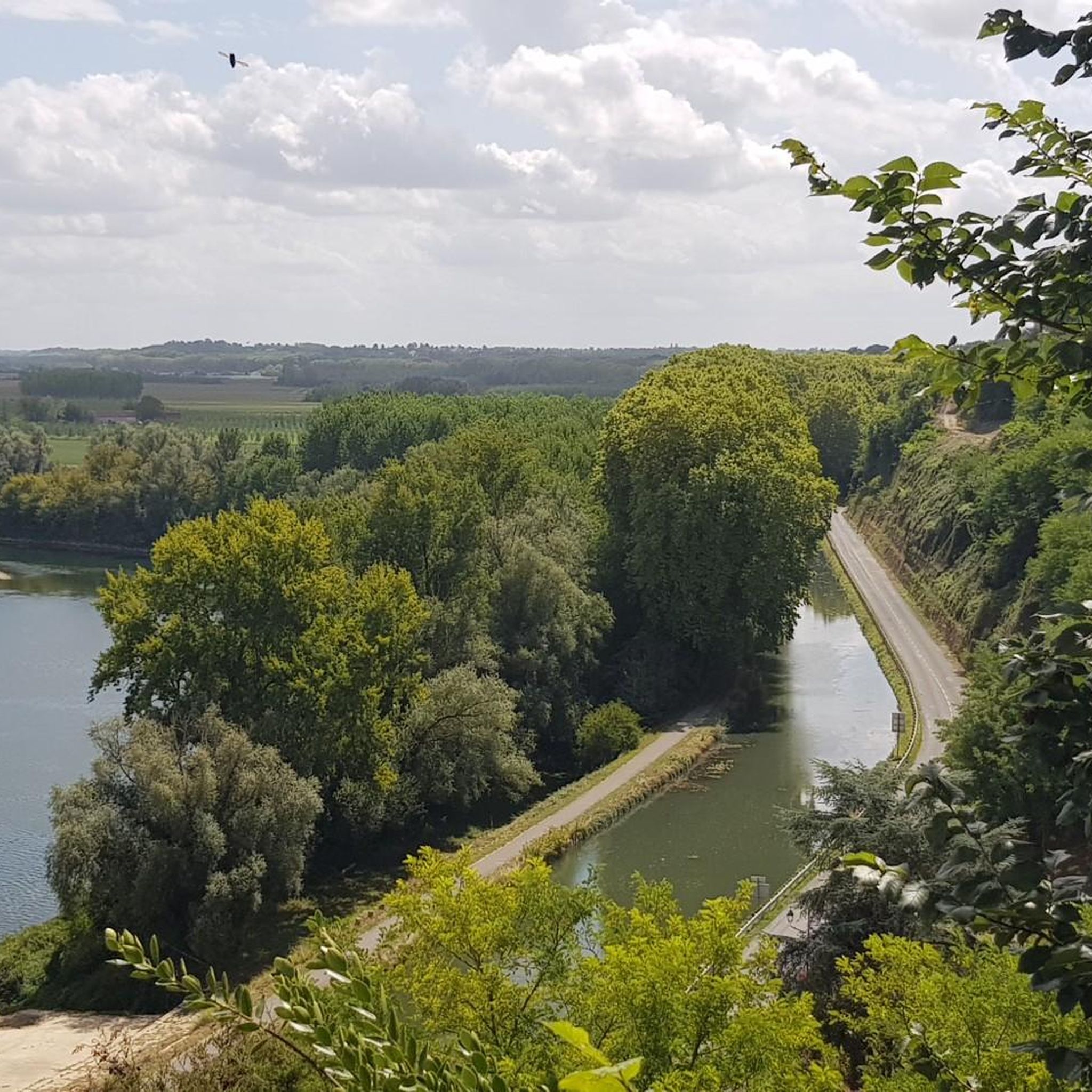
Aqueduct of the Garonne canal.
0
0

I hope a bit of advertising is allowed. There is a marvellous B&B / gîte - Haras de la Tour - just 2.5 km off all of these routes at Lamothe-Landerron. Many cyclists have stayed here. Have a look at http://www.harastour.com/ It is 5 km from the start point at Sainte-Bazeille. If you get lost I can come and cycle back with you.
0
0

The viewing terrace is in the wrong place! At this point there is only one information sign.
0
0


Small bucolic pond in the countryside, with picnic tables.
1
0

A pleasant place on the canal to watch the boats pass by or even race alongside them.
3
0

Idyllic place for ships to dock.
1
0
Frequently Asked Questions
How many hiking trails are available around Saint-Sauveur-De-Meilhan?
There are over 30 hiking routes available around Saint-Sauveur-De-Meilhan. These trails cater to various preferences, ranging from easy strolls to more challenging paths, allowing you to explore the diverse landscapes of the region.
What kind of landscapes can I expect to see while hiking in Saint-Sauveur-De-Meilhan?
Hiking in Saint-Sauveur-De-Meilhan offers a blend of rural landscapes. You'll encounter extensive vineyards, reminiscent of the Bordeaux wine region, along with sheep pastures and significant woodlands. The terrain transitions from the Garonne plain to gently rising hills, providing varied views and experiences. The area is also characterized by the riparian forests along the Lisos river.
Are there any easy or beginner-friendly hiking routes?
Yes, Saint-Sauveur-De-Meilhan offers a good selection of easy hikes suitable for beginners. For instance, the Ship birth on the canal – Aqueduct in Meilhan-sur-Garonne loop from Meilhan-sur-Garonne is an easy 3.5 km trail that takes about 1 hour to complete, following the Canal de Garonne. Another gentle option is the Bois de Marquésine loop from Cimetière de Goutz, a 3.5 km woodland path.
Are there any circular hiking routes in the area?
Yes, many of the trails around Saint-Sauveur-De-Meilhan are circular, offering convenient starting and ending points. A notable local loop is a 6.3 km trail starting from the town hall, which takes approximately 2 hours and 15 minutes, passing through vineyards and shaded paths. Other examples include the Lac de Sigalens – Fish pond loop from Sigalens and the longer Lac de Sigalens loop from Sigalens.
What natural features or wildlife can I observe along the trails?
The Lisos river, which borders the commune, is a Natura 2000 site, indicating its high biodiversity. Along its natural banks, you can find rich riparian forests, providing habitats for protected species such as the European mink and otter. Historically, the Lisos also powered six mills, some vestiges of which can still be found. The area's woodlands and pastures also offer opportunities for general wildlife observation.
What interesting landmarks or attractions can I see near the hiking trails?
While hiking, you can explore several points of interest. The Garonne Lateral Canal and the Bassanne Lock are prominent features, especially on trails along the canal. You might also encounter the remnants of the old village on the hills, including its cemetery, close to some hiking paths. The charming Couthures-sur-Garonne Riverside Village is also nearby.
Are there family-friendly hiking options in Saint-Sauveur-De-Meilhan?
Yes, the region offers several family-friendly hiking options, particularly the easier, shorter loop trails. The 3.5 km Ship birth on the canal – Aqueduct in Meilhan-sur-Garonne loop is a great choice for families, offering flat paths along the canal. The 6.3 km loop from the town hall is also suitable for families looking for a moderate walk with varied scenery.
Can I bring my dog on the hiking trails?
Many trails in the Saint-Sauveur-De-Meilhan area are suitable for dogs, especially those through woodlands and along the canal. However, it's always recommended to keep your dog on a leash, particularly in agricultural areas or near wildlife habitats like the Natura 2000 site along the Lisos river, and to respect local regulations regarding pets.
What is the best time of year to go hiking in Saint-Sauveur-De-Meilhan?
The spring and autumn months are generally ideal for hiking in Saint-Sauveur-De-Meilhan. During these seasons, the weather is typically mild and pleasant, perfect for enjoying the vineyards and woodlands. Summer can be warm, so early mornings or late afternoons are preferable, while winter offers a quieter experience, though some paths might be muddy.
Is parking available near the trailheads?
Yes, for many of the trails, especially those starting from villages or specific points of interest, you will find designated parking areas. For example, the 6.3 km loop trail mentioned in the region research starts from the town hall, where parking is typically available. Routes along the Canal de Garonne also often have parking options nearby.
What do other hikers enjoy most about hiking in Saint-Sauveur-De-Meilhan?
The area is highly rated by the komoot community, with an average score of 4.5 stars from around 20 reviews. Hikers often praise the tranquil rural setting, the scenic vineyards, and the peaceful paths along the Canal de Garonne. The diversity of landscapes, from riverine forests to rolling hills, is also frequently highlighted.
Are there longer, more challenging hikes available?
Yes, for those seeking a longer experience, the The Canal Latéral à la Garonne – Canal de Garonne at Meilhan loop from Fontet is a moderate 13.2 km path offering extended views along the Canal de Garonne. There are also 4 routes classified as difficult, providing more strenuous options for experienced hikers.
Most popular routes around Saint-Sauveur-De-Meilhan
Most popular attractions around Saint-Sauveur-De-Meilhan

Get inspired with the komoot mobile app


Explore more
Browse the best Hikes in other regions.
