The best MTB trails around Ohlungen
4.6
(103)
564
riders
134
rides
Mountain bike trails around Ohlungen are characterized by diverse landscapes, including the dense Ohlungen Forest and the hilly terrain of the Pays de Haguenau. The region features a mix of pinewoods, deciduous stands, and agricultural fields, with some routes offering views towards the Northern Vosges and the Black Forest. The Moder River flows through the area, with many routes incorporating its banks, providing a blend of paved and unpaved surfaces. This varied topography offers both challenging and accessible terrain for…
Last updated: July 5, 2026
5.0
(1)
8
riders
43.3km
03:02
320m
320m
Moderate mountain bike ride. Good fitness required. Advanced riding skills necessary.
5.0
(1)
10
riders
64.3km
03:42
300m
300m
Moderate mountain bike ride. Good fitness required. Suitable for all skill levels.

Sign up for free
3.5
(2)
5
riders
22.5km
01:47
270m
270m
Moderate mountain bike ride. Great for any fitness level. Advanced riding skills necessary.
5.0
(1)
3
riders
59.6km
04:33
560m
560m
Moderate mountain bike ride. Good fitness required. Advanced riding skills necessary.
7
riders
Moderate mountain bike ride. Good fitness required. Suitable for all skill levels.
Get access to more routes and recommendations from other explorers.
Sign up for free
Already have an account?
Our route recommendations are based on thousands of hikes, rides, and runs completed by other people on komoot.
Start today with a free account
Your next adventure awaits.
Login or Signup

Tips from the Community

The observatory is well located, it allowed us to observe, for example, geese, herons, and carp. Provided we stay quiet, of course. The flora is also very beautiful around the pond
0
0

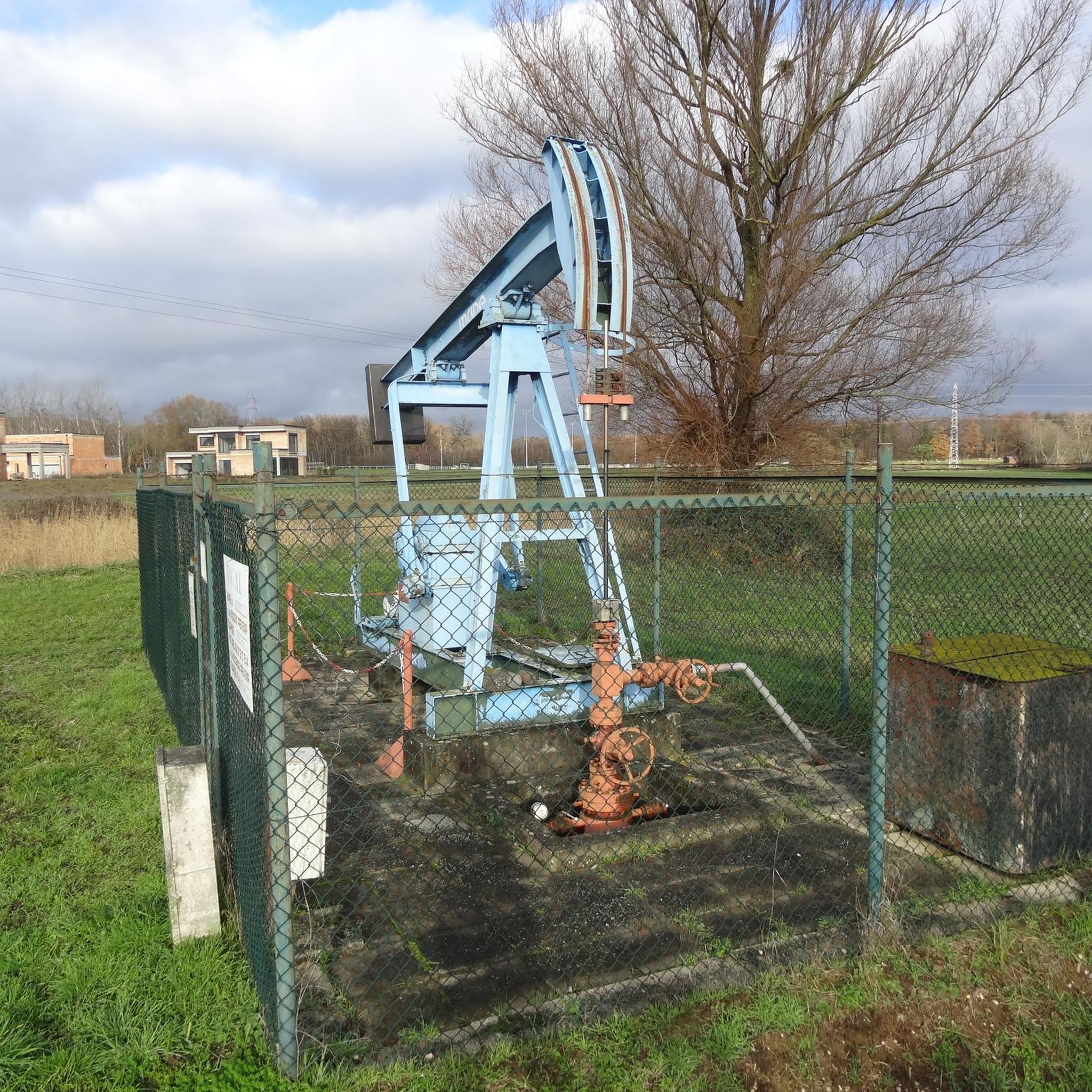
With such drilling rigs, more than 5000 test drillings were carried out in Alsace from 1813 onwards, and oil deposits were discovered in the subsurface. According to the panel, this oil exploration drilling rig was the first of its kind in the world.
0
0

And every bunker had a squat toilet.
1
0
It's incredible that the gable walls and columns from the 16th century are still standing today.
1
0

Here you'll find a covered wash fountain with benches inside for a rest. Directly opposite, covered hiking maps are located in a small wooden hut.
0
0

Impressive ruins right next to the road, plus a pretty reservoir surrounded by forest.
1
0

Beautiful small reservoir with the ruins
1
0

The Maginot Line: The French Wall | ARTE https://youtu.be/Bvtxa08ysgc For those who would like to know more about the Maginot Line: de.wikipedia.org/wiki/Liste_der_Ouvrages_der_Maginot-Linie
1
0
Frequently Asked Questions
What kind of terrain can I expect on mountain bike trails around Ohlungen?
The mountain bike trails around Ohlungen offer a diverse landscape. You'll encounter dense forests, particularly the Ohlungen Forest, and the hilly terrain characteristic of the Pays de Haguenau. Routes often feature a mix of pinewoods, deciduous stands, and agricultural fields. Many trails also incorporate the banks of the Moder River, providing both paved and unpaved sections. This varied topography ensures a range of experiences, from challenging climbs to scenic riverside rides.
Are there mountain bike trails suitable for beginners in Ohlungen?
Yes, Ohlungen offers trails suitable for various skill levels. While many routes are classified as moderate, there are approximately 39 easy trails available. These easier paths are perfect for those new to mountain biking or looking for a more relaxed ride through the region's beautiful landscapes.
What is the overall difficulty level of mountain biking in Ohlungen?
The majority of mountain bike trails in Ohlungen are rated as moderate, making them suitable for riders with some experience. There are 78 moderate routes, 39 easy routes, and 1 difficult route. This variety ensures that both casual riders and those seeking a more strenuous challenge can find suitable options.
Can I find circular mountain bike routes in the Ohlungen area?
Yes, many mountain bike routes around Ohlungen are designed as loops, allowing you to start and finish at the same point. For example, the Geiersberg – Maginot Line mine cart loop from Berstheim is a moderate 22.5 km circular route that takes about 1 hour 47 minutes to complete.
Are there any historical or natural landmarks to see along the mountain bike trails?
Yes, the region offers several points of interest. You can explore historical sites like the Forges de Jaegertahl Ruins, which are part of the Forges de Jaegertahl Ruins – Étang de Fleckenstein loop from Schweighouse-sur-Moder. The serene Étang de Fleckenstein is also a notable natural attraction. Additionally, you might pass by the Villa Meteor or the Historical Museum of Haguenau, depending on your chosen route.
What do other mountain bikers say about the trails in Ohlungen?
The mountain bike trails in Ohlungen are highly regarded by the komoot community, holding an average rating of 4.5 stars from over 100 reviews. Riders often praise the diverse landscapes, including the dense forests and riverine paths along the Moder River, as well as the variety of options available for different ability levels.
Are there any long-distance mountain bike routes available?
Yes, Ohlungen offers several longer routes for more experienced riders. For instance, the Saverne Marina – Moder River loop from Schweighouse-sur-Moder is a challenging 80.5 km route that typically takes around 4 hours 44 minutes to complete, offering extensive exploration of the region.
What are the typical elevation gains on mountain bike trails in Ohlungen?
Elevation gains vary significantly depending on the trail. While some routes are relatively flat, especially those along the Moder River, others can involve substantial climbing. For example, the Soultzerkopf Hut – Moder River loop from Schweighouse-sur-Moder features an elevation gain of over 560 meters, providing a good workout for riders.
Is it possible to access mountain bike trails in Ohlungen using public transport?
While specific public transport links directly to trailheads can vary, the region is generally accessible. Haguenau station (Haguenau station) serves as a key transport hub in the wider area, and from there, local connections or a short ride might get you to various starting points. It's advisable to check local bus schedules for specific routes.
What is the best time of year for mountain biking in Ohlungen?
The region's diverse landscapes, including pinewoods and deciduous stands, make spring and autumn particularly appealing for mountain biking, with pleasant temperatures and vibrant scenery. Summer offers longer daylight hours, though some forest sections provide welcome shade. Winter riding is possible, but conditions can be more challenging due to potential mud or snow, especially on higher or less maintained trails.
Are there any family-friendly mountain bike options in Ohlungen?
Yes, among the 118 available mountain bike tours, there are approximately 39 routes classified as easy, which are generally more suitable for families or those with less experience. These trails often follow gentler gradients and can be found in areas like the Ohlungen Forest or along the Moder River, providing a pleasant outdoor experience for all ages.
Most popular attractions around Ohlungen

Get inspired with the komoot mobile app


Explore more
Browse the best MTB trails in other regions.
