The best running trails around Hohes Moor (Hannover)
4.8
(15)
227
runners
28
runs
Jogging routes around Hohes Moor (Hannover) traverse distinctive moorland landscapes characterized by wet swamp areas, small lakes, and forests. The terrain includes varied surfaces, from soft and rooty paths to wooden walkways that protect the delicate ecosystem. This region, recognized as a unique raised bog, offers a mix of flat sections and gently hilly areas suitable for running.
Best jogging routes around Hohes Moor (Hannover)
- The most popular jogging route is Franzosenstein on Knickberg – Kirchdorfer Heide loop from Hohes…
Last updated: July 15, 2026
5.0
(1)
6
runners
Moderate run. Good fitness required. Mostly paved surfaces. Suitable for all skill levels.
2
runners
5.09km
00:36
20m
20m
Moderate run. Good fitness required. Mostly paved surfaces. Suitable for all skill levels.

Sign up for free
2
runners
4.20km
00:28
10m
10m
Easy run. Great for any fitness level. Mostly paved surfaces. Suitable for all skill levels.
3
runners
Moderate run. Good fitness required. Mostly paved surfaces. Suitable for all skill levels.
4.0
(1)
3
runners
11.7km
01:22
60m
60m
Moderate run. Good fitness required. Mostly paved surfaces. Suitable for all skill levels.
Get access to more routes and recommendations from other explorers.
Sign up for free
Already have an account?
Our route recommendations are based on thousands of hikes, rides, and runs completed by other people on komoot.
Start today with a free account
Your next adventure awaits.
Login or Signup
Tips from the Community

Nice place to make a stopover 👍
1
0

A "highlight" of the Kirchdorfer-/Kuppendorfer Heide-Rund; you have to do it ;-).
1
0

The little detour is well worth it
1
0

Unique bathing experience with the best water quality.
1
0
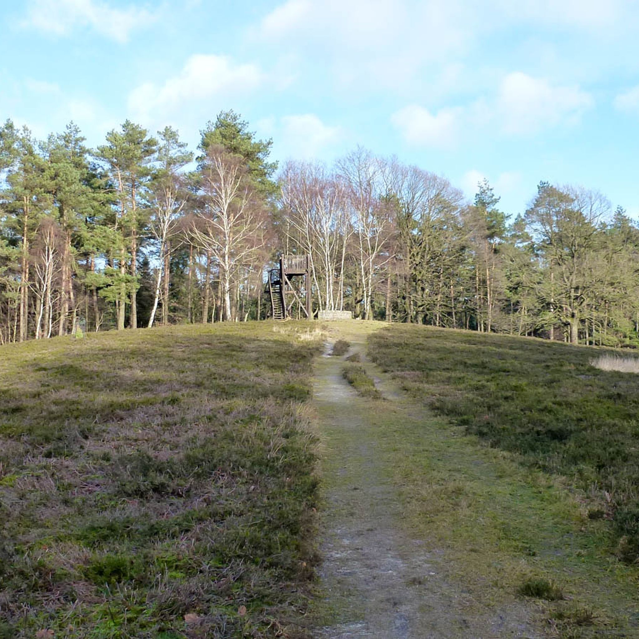
Local recreation area with Franzosenstein – 86 m above sea level.
1
0

Here, the hiking car park on the heath invites you to the starting point for a tour through the heath. In addition to the wildlife on the heath, there is the nearby Knickberg with a height of 85m to discover.
1
0
Nice covered rest area on the heath. Ideal for a break, you can sometimes watch deer grazing. There is also a hiking trail that invites you to take a short walk.
1
0
Little info from the internet: The Frenchman's Stone Today it is still called “Franzosenstein”, the one meter high sandstone column on the highest point in the community of Kirchdorf. This relic from the past always puzzles visitors. The following is recorded in the Kirchdorf community archive: Kirchdorf, which belonged to the Uchte district under Hessian administration, came under French rule in 1803. Under the direction of Colonel Epailly, survey officers erected a twelve meter high tower. At this point a first order triangle network (“Canevas die Triangles du Ier ordere executes par M. Epailly”). From here the following main points were recorded: the church towers of Twistringen and Asendorf, the signal towers on the Mordkulenberg west of the Dümmer in the Dammer Mountains (141 m above sea level), on the Hüttenberg in Grinderwald (101 m above sea level), a mountain near Loccum and the Knickberg (86 m above sea level). At the same time, French observers were able to monitor events in all directions. In 1813, after the French era, Kirchdorf fell back to Hesse and the twelve meter high tower was destroyed. In 1814, Prince Regent George of Hanover and England elevated his electorate to a kingdom, including the Hessian territories. In 1816, King George IV ordered the extension of triangulation to the entire Kingdom of Hanover. Under the direction of C. F. Gauß, the survey work also began on the Knickberg, for which he had a stone built with a pedestal and a slab on top, which fell victim to deliberate destruction. As a replacement, a one meter high sandstone pillar was erected with the carved inscription “Königl. Hann. Country. Surveying.”. This stone still stands on the Knickberg today, which is incorrectly referred to as the “Franzosenstein”. Perhaps arbitrarily by the Prussians who annexed Hanover in 1866 after the Battle of Langensalza. In 1886/87, as part of the Prussian survey, Prussian surveying officers built a wooden tower on a stone foundation at this point, which was then called the French Tower. After about 25 years, this too disappeared. In 1919 the decree came that no more towers should be erected. Today's visitor is no longer able to look out from all sides of the Knickberg. He is in the middle of the forest, where a bench invites him to rest. Not far from the supposed “French stone” there has been an embedded square stone with a cross for years, the so-called “trigonometric point”, which serves as a survey point for our land registry office for the height of the Knickberg (86 m above sea level).
1
0
Frequently Asked Questions
What kind of terrain can I expect on the running trails in Hohes Moor (Hannover)?
The running routes in Hohes Moor offer a diverse terrain, characterized by mystical moorland landscapes, wet swamp areas, and forests. You'll encounter varied surfaces, from soft and rooty paths to well-maintained wooden walkways that protect the delicate ecosystem. Some routes feature small fords with stepping stones and wooden bridges, adding an adventurous element to your run. The area includes both flat sections and gently hilly areas.
Are there running routes suitable for beginners in Hohes Moor (Hannover)?
Yes, Hohes Moor offers routes for various fitness levels, including options suitable for beginners. For instance, the Running loop from Kirchdorf bei Sulingen is an easy 4.2 km (2.6 miles) trail that takes about 28 minutes to complete, providing a gentle introduction to the area's natural beauty.
Are there circular running routes available in Hohes Moor (Hannover)?
Absolutely. Many of the running trails in Hohes Moor are circular, allowing you to start and end at the same point. A popular choice is the Franzosenstein on Knickberg – Kirchdorfer Heide loop from Hohes Moor, a 6.1 km (3.8 miles) route that offers varied terrain through forests and moorland.
Can I bring my dog on the running trails in Hohes Moor (Hannover)?
While the region is beautiful for outdoor activities, specific regulations regarding dogs in the Hohes Moor Nature Reserve can vary. It's generally advisable to keep dogs on a leash to protect the sensitive moorland ecosystem and its unique wildlife. Always check local signage for the most current rules.
What natural features or attractions can I see while running in Hohes Moor?
While running, you'll experience the unique mystical moorland landscapes, small lakes, and forests. The Hohes Moor Nature Reserve itself is a highlight, with wooden walkways offering fantastic views. You might also spot special wildlife like cranes and unique plants such as sundews. The area around Kirchdorfer Heide – Franzosenstein on Knickberg loop from Kirchdorf bei Sulingen also provides diverse scenery.
Where can I park when visiting Hohes Moor for a run?
A convenient parking option is available at Herbert's Hut, located at the edge of the Hohes Moor. This area provides a well-maintained parking lot and direct access to the moor trails, making it an ideal starting point for your run.
How many running routes are available in Hohes Moor (Hannover)?
There are over 30 running routes available in Hohes Moor (Hannover), catering to various distances and difficulty levels. This extensive network ensures there's a suitable path for almost every runner.
What do other runners say about the trails in Hohes Moor (Hannover)?
The running routes in Hohes Moor are highly rated by the komoot community, with an average score of 4.8 out of 5 stars from over 16 reviews. Runners often praise the unique moorland landscapes, the varied terrain, and the well-maintained paths, highlighting the immersive experience in nature.
When is the best time of year to go running in Hohes Moor?
Hohes Moor offers a beautiful landscape in every season. However, for running, spring and autumn often provide the most comfortable temperatures and stunning natural colors. During wetter periods, some paths might be mushy, so appropriate footwear is recommended. The wooden walkways make many areas accessible year-round.
Are there any facilities or cafes near the running routes in Hohes Moor?
While the Hohes Moor is primarily a natural reserve, Herbert's Hut, located at the edge of the moor, offers a refuge built in 2021. For cafes or restaurants, you would typically need to venture into nearby towns or villages surrounding the moor, such as Kirchdorf bei Sulingen.
What kind of wildlife might I encounter while running in Hohes Moor?
The Hohes Moor Nature Reserve is home to special wildlife. You might encounter cranes, known for their loud trumpeting calls, and unique plants like sundews. It's also known to be home to the poisonous adder, so staying on marked trails is crucial for both your safety and the preservation of the delicate ecosystem.
Are there any longer running routes for more experienced runners?
Yes, for those seeking a longer challenge, routes like the Kirchdorfer Heide – Franzosenstein on Knickberg loop from Kirchdorf bei Sulingen offer a moderate 8.0 km (5.0 miles) path. This route provides an engaging experience through unique moorland landscapes and forests, with varied scenery.
Are the running trails well-marked in Hohes Moor?
Yes, it is crucial to stay on the marked trails for safety and to preserve the bog's delicate ecosystem. The trails often feature information boards providing insights into the natural surroundings, which also helps with navigation.
Most popular routes around Hohes Moor (Hannover)

Get inspired with the komoot mobile app


Explore more
Browse the best Running Trails & Routes in other regions.
