The best walks and hikes around Cogeces De Íscar
4.8
(4)
32
hikers
9
hikes
Hiking around Cogeces De Íscar offers routes through the varied landscape of the Valladolid province. The region is characterized by its pine forests, agricultural fields, and the presence of the Cega River, providing a mix of riverside paths and woodland trails. Gentle undulations define the terrain, with no significant mountain peaks, making it suitable for accessible outdoor activities. The area features a network of trails that connect rural villages and natural spaces.
Best hiking trails around Cogeces De Íscar
- The…
Last updated: July 2, 2026
5.0
(1)
7
hikers
14.0km
03:42
130m
130m
Moderate hike. Good fitness required. Easily-accessible paths. Suitable for all skill levels.
5
hikers
7.95km
02:02
30m
30m
Moderate hike. Good fitness required. Easily-accessible paths. Suitable for all skill levels.

Sign up for free
5.0
(1)
1
hikers
17.1km
04:24
90m
90m
Moderate hike. Good fitness required. Easily-accessible paths. Suitable for all skill levels.
17.4km
04:39
180m
180m
Moderate hike. Good fitness required. Easily-accessible paths. Suitable for all skill levels.
5.0
(1)
10
hikers
13.5km
03:31
90m
80m
Moderate hike. Good fitness required. Easily-accessible paths. Suitable for all skill levels.
Get access to more routes and recommendations from other explorers.
Sign up for free
Already have an account?
Our route recommendations are based on thousands of hikes, rides, and runs completed by other people on komoot.
Start today with a free account
Your next adventure awaits.
Login or Signup

Tips from the Community

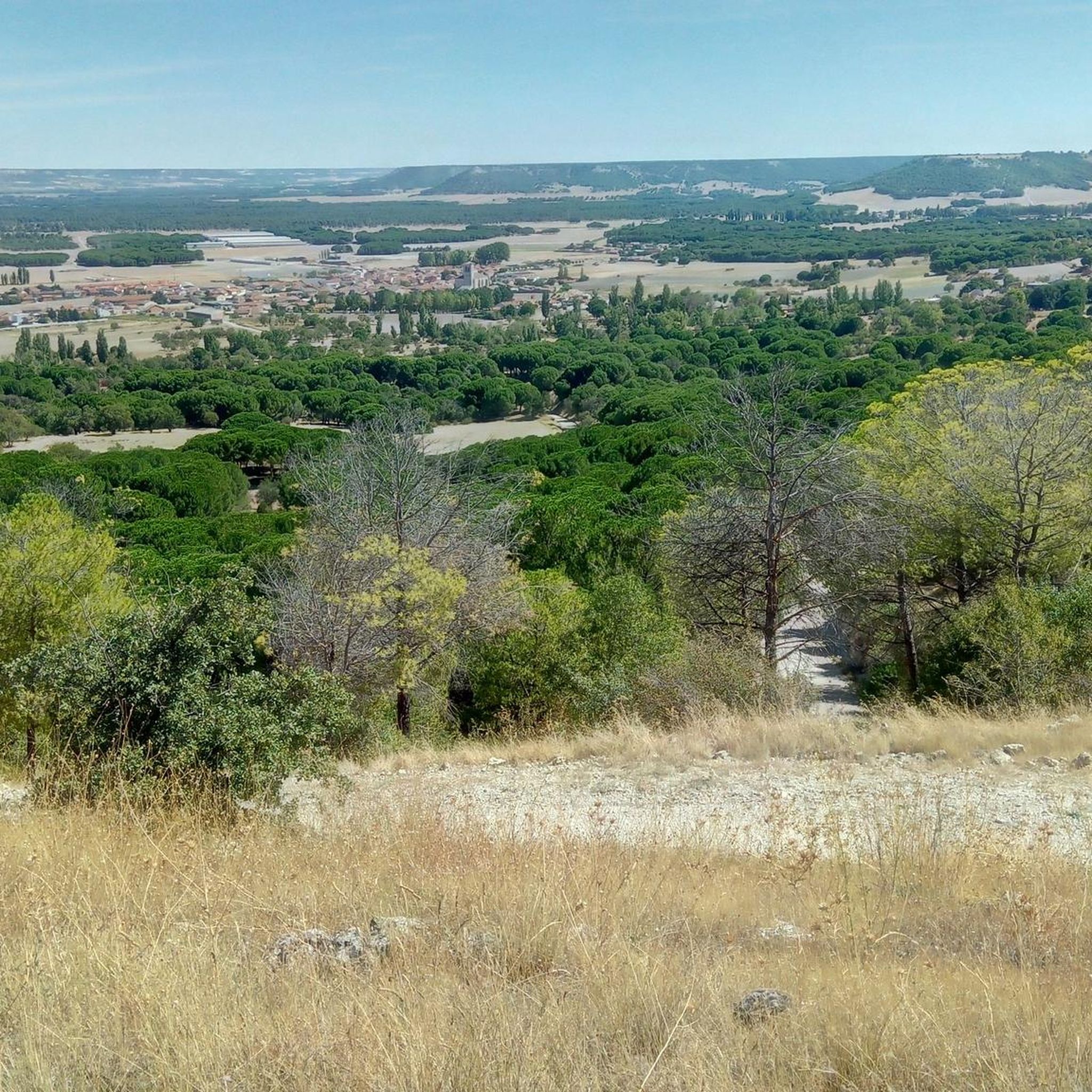
Beautiful view of the Cea valley, Cogeces de Íscar and Megeces
0
1
From this route there is a beautiful view of the surrounding valleys and hills. In this case, over the hill and valley, a view of Portillo and Arrabal. To the left of the image, the Raso de Portillo, Boecillo and, in the background, the Pisuerga valley, Valladolid and Torozos.
0
0
From the edge of the San Marugán hill there is a beautiful view of the surrounding valleys. In this case, the valley of the Arroyo del Henar and three villages: Santiago del Arroyo, Camporredondo and Montemayor de Pililla.
0
0

The castle of Portillo stands on top of a hill that dominates Tierra de Pinares. Built in the 14th century and restored in the 15th century, the castle was the scene of the arrest and imprisonment of Álvaro de Luna. It represents the power and wealth of its lords, with a square structure, keep, barbican and three fortified gates. In its parade ground there is a well more than 30 meters deep.
1
0

Very good singletrack trails in the woods to get to this point.
1
0

Viewpoint to the plain and agricultural fields around Megeces and to the forests of Mount Saint Marugan.
2
0
8 km circular path that begins its route in the Recreational Area of Puente Blanca (Íscar). The path goes along the banks of the River Cega and the River Pirón and crosses stone pine (Pinus pinea) and resin pine (Pinus pinaster) forests with the presence of holm oaks (Quercus ilex).
2
0
Small dam with a power switchboard next to the remains of a medieval bridge.
2
0
Frequently Asked Questions
How many hiking trails are available in Cogeces De Íscar?
There are 8 hiking trails documented around Cogeces De Íscar on komoot, offering a variety of experiences. Most of these, 7 to be exact, are rated as moderate, with one trail considered difficult.
Are there any easy or beginner-friendly hiking trails in Cogeces De Íscar?
While most trails are rated moderate, the gently undulating terrain of Cogeces De Íscar, characterized by pine forests and agricultural fields, makes many routes accessible for beginners. For example, the Senda de la Resina (PRC-VA 38) — circular desde Puente Blanca is a moderate 4.9-mile (7.9 km) path with a relatively flat profile, making it a good option for those new to hiking.
Can I find circular hiking routes in the area?
Yes, Cogeces De Íscar offers several excellent circular hiking routes. Popular options include the Senda de la Resina (PRC-VA 38) — circular desde Puente Blanca, the Senda del Ermitaño and Presa de Alcazarén Loop, and the Return to Monte San Marugan (PRC-VA 61) — circular from Megeces.
What kind of landscapes can I expect to see while hiking around Cogeces De Íscar?
Hiking around Cogeces De Íscar will immerse you in the varied landscape of the Valladolid province. You'll encounter extensive pine forests, open agricultural fields, and paths along the Cega River. The terrain features gentle undulations, providing a mix of woodland and riverside trails without significant mountain climbs.
Are there any historical sites or landmarks to explore near the trails?
Yes, the region around Cogeces De Íscar is rich in history and offers several interesting landmarks. You can visit Portillo Castle or Íscar Castle, explore the historic Megeces Bridge, or see the San Juan Church in Mojados.
What do other hikers say about the trails in Cogeces De Íscar?
The trails in Cogeces De Íscar are highly regarded by the komoot community, boasting an average rating of 4.75 stars from over 4 reviews. Hikers often praise the peaceful pine forests, the well-maintained paths, and the opportunity to connect with nature in this tranquil region.
Are the hiking trails in Cogeces De Íscar suitable for families with children?
Given the gently undulating terrain and the prevalence of moderate trails, many routes in Cogeces De Íscar are suitable for families. The natural environment, with its pine forests and river paths, offers a pleasant setting for children to explore. Shorter circular routes like the Senda de la Resina are particularly good for family outings.
Is Cogeces De Íscar a good destination for dog-friendly hiking?
Yes, Cogeces De Íscar is generally a dog-friendly region for hiking. The numerous trails through pine forests and open countryside provide ample space for dogs to enjoy. Always ensure your dog is under control, especially near agricultural areas or wildlife, and check local regulations for specific trails.
What is the best time of year to go hiking in Cogeces De Íscar?
The best time to hike in Cogeces De Íscar is typically during spring (April to June) and autumn (September to October). During these seasons, the weather is mild and pleasant, and the natural scenery is vibrant with spring blooms or autumn colors. Summers can be hot, while winters are generally mild but can be damp.
Are there any trails that offer good viewpoints?
Yes, for those seeking panoramic views, the Mirador de Julin – Pico del Águila Viewpoint loop from Megeces is an excellent choice. This route specifically highlights a viewpoint, allowing hikers to enjoy broader vistas of the surrounding landscape, including the pine forests and agricultural plains.
Where can I find parking for the hiking trails in Cogeces De Íscar?
Parking for hiking trails in Cogeces De Íscar is generally available in or near the villages that serve as starting points for the routes, such as Cogeces De Íscar itself or nearby Megeces. Look for designated parking areas or roadside spaces, especially near trailheads or local amenities.
Are there any longer distance hiking options for experienced hikers?
For experienced hikers looking for longer distances, Cogeces De Íscar offers routes like the Return to Monte San Marugan (PRC-VA 61) — circular from Megeces, which spans over 17 km, or the Senda del Ermitaño and Presa de Alcazarén Loop, also over 17 km. These routes provide a good challenge and allow for a more extended exploration of the region's diverse terrain.
Are there any cafes or places to eat near the hiking trails?
Yes, you can find cafes and local eateries in the villages surrounding the hiking trails, such as Cogeces De Íscar, Megeces, or Mojados. These establishments offer a chance to refuel and experience local cuisine before or after your hike.
Most popular attractions around Cogeces De Íscar

Get inspired with the komoot mobile app


Explore more
Browse the best Hikes in other regions.
