The best cycling routes around Clarkill
4.7
(33)
412
riders
12
rides
Touring cycling routes around Clarkill traverse a landscape characterized by rolling hills, scenic lakes, and historic waterways. The region features varied terrain, from gentle paths alongside the Newry Canal to more challenging ascents around Slieve Gullion. Cyclists can expect a mix of open countryside, forested areas, and views of natural features like Camlough Lake.
Best touring cycling routes around Clarkill
- The most popular touring cycling route is Giant's Lair – View of Slieve Gullion loop from Meigh, an 11.6…
Last updated: June 27, 2026
5.0
(10)
39
riders
18.2km
01:30
430m
430m
Moderate bike ride. Good fitness required. Mostly paved surfaces. Suitable for all skill levels.
38
riders
19.0km
01:11
190m
190m
Moderate bike ride. Good fitness required. Mostly paved surfaces. Suitable for all skill levels.

Sign up for free
6
riders
55.6km
03:19
410m
410m
Moderate bike ride. Good fitness required. Mostly paved surfaces. Suitable for all skill levels.
6
riders
Easy bike ride. Great for any fitness level. Mostly paved surfaces. Suitable for all skill levels.
5.0
(2)
4
riders
15.5km
01:01
190m
190m
Moderate bike ride. Good fitness required. Mostly paved surfaces. Suitable for all skill levels.
Get access to more routes and recommendations from other explorers.
Sign up for free
Already have an account?
Our route recommendations are based on thousands of hikes, rides, and runs completed by other people on komoot.
Start today with a free account
Your next adventure awaits.
Login or Signup


Tips from the Community

Along the route through Dundalk, the Sìocháin monument in Louth Peace Park forms a serene resting point. This impressive memorial, whose name bears the Irish word for 'Peace', was erected in memory of the residents of County Louth who lost their lives in global conflicts and to promote reconciliation on the island. The park itself is an oasis of tranquility with clean lines, symbolic sculptures, and carefully planted memorial trees.
8
0
Between the rustling trees along the Newry Canal Towpath, you'll encounter the tranquil ruin of a lock keeper's cottage. Once, this was the proud and bustling heart of the waterway, where the lock keeper stood ready day and night to operate the heavy wooden canal gates for passing barges. Today, only the robust stone walls remain, slowly being reclaimed by nature.
6
0
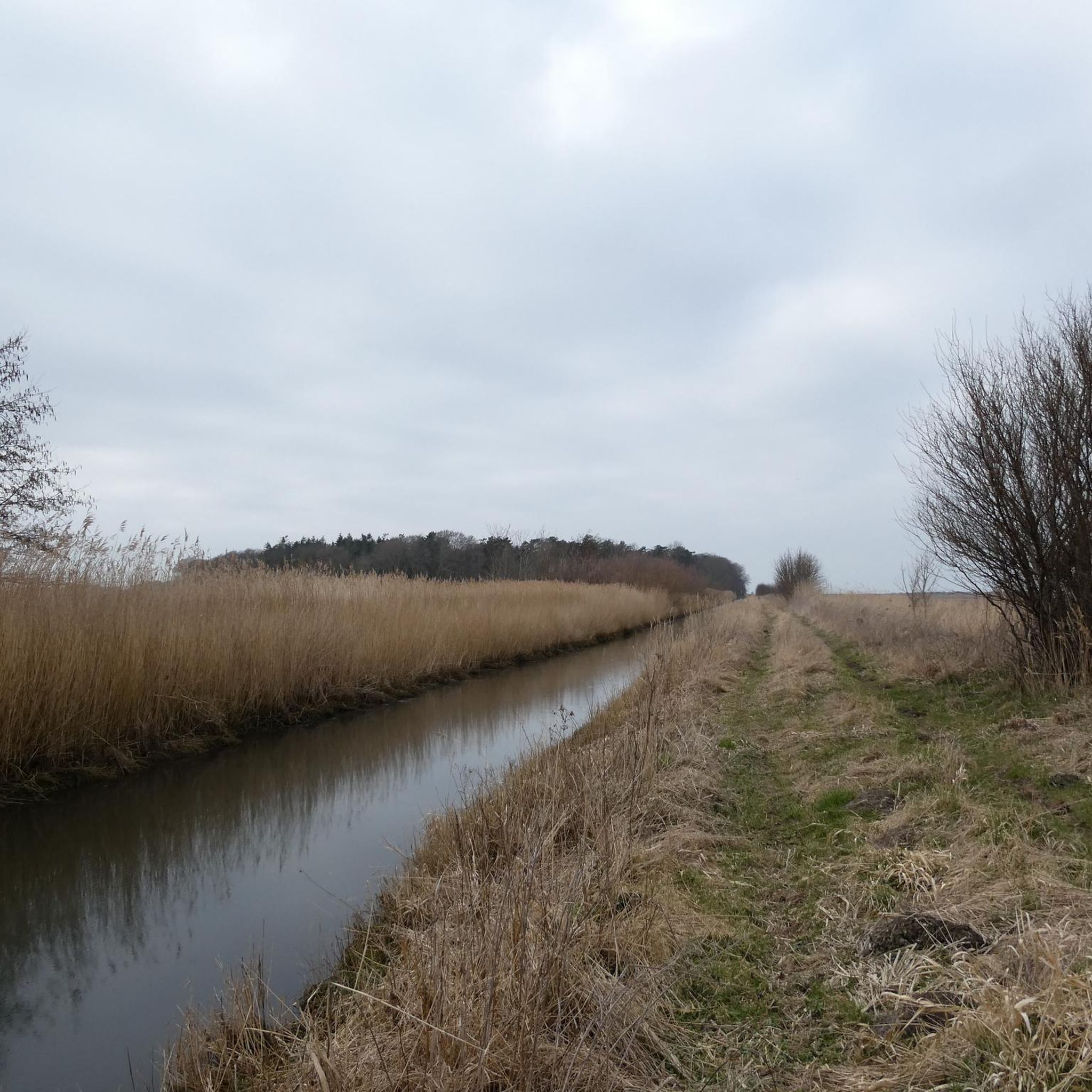
Quiet canal section south of Poyntzpass, where the towpath runs tightly along the narrow water. The bank is lightly overgrown with low trees and hedges, giving the stretch an intimate, green impression. The water is mostly still, forming a straight line through the open agricultural landscape. An even, traffic-free segment ideal for quiet miles on the towpath.
5
0

The highest bar in County Louth along the Táin Way. A traditional Irish pub that offers a cozy interior with a warming fire and excellent food. A favourite amongst locals and hikers!
0
0

We had an amazing day thanks to Ring of Gullion Cycle Tours. Our bikes were well maintained and service was exceptional. We were advised by proprietor James to take the Cooley Tour through this app as the weather was spectacular and it was such good advice. Also recommended a stop off at Lumpers Bar and added a drink voucher for good measure. I can’t recommend these guys enough. The service and standard of care was truly amazing. Do yourself a favour and drop in here and do some cycling - or buy your own bike!!
1
0

The Táin Way is a 40 kilometre (25 mi) circular hiking trail that starts and ends in Carlingford. Named after the ancient Irish epic "Táin Bó Cúailnge", the route winds through the Cooley Peninsula, offering a mix of coastal views, forest paths, and mountain tracks. Typically completed over two days, the trail includes a total ascent of about 1,025 meters and is marked with yellow arrows on a black background. Along the way, hikers encounter historical sites like Bronze Age cairns and enjoy panoramic vistas of Carlingford Lough and the Mourne Mountains. Alternative trailheads are available at Omeath and Ravensdale, providing flexibility for different starting points. Please note that dogs are not permitted on farmland sections of the trail.
1
0

There is something enchanted about this old, dilapidated stone hut - as if it were whispering stories of times gone by, when the canal was still full of life and the lock keepers worked here day and night. The walls, overgrown with greenery and moss, show how nature is slowly reclaiming its place. The building itself is only a ruin, but that is precisely what makes it somehow interesting. The mixture of broken brickwork and wild growth has something melancholic about it that fits perfectly into the tranquility of the surroundings. Right next to it there is a small rest area with a bench - ideal for stopping for a moment and taking in the atmosphere.
1
0
The setting is done with great attention to detail, and it almost feels like a quick picnic in the mountains when you sit down at the rustic tables and look into the distance. The patterned cups and saucers give the place a cozy touch and make the whole thing that little bit more special. The view of the surrounding hills and the relaxed atmosphere invite you to take a short break - perfect for resting your legs and just taking a breather. The coffee house is not only friendly to cyclists, but even offers bike rental for the Ring of Gullion. Handy if you need an extra boost for the next stage! The surroundings are green and spacious, a nice mix of Irish idyll and relaxed hospitality. The owners seem to take the attention to detail seriously, which is reflected in the little things like the decorative elements and the cozy atmosphere.
1
0
Frequently Asked Questions
What kind of terrain can I expect on touring cycling routes around Clarkill?
Touring cycling routes around Clarkill feature a diverse landscape, characterized by rolling hills, tranquil lakes, and historic canal paths. You'll find a mix of open countryside, forested areas, and scenic views of natural features like Camlough Lake. Some routes, such as the Clermont Carn – Carnavaddy loop from Flurrybridge, involve significant elevation gain, while others like the Lock Keeper's Cottage Ruins – Newry Canal Towpath loop from Bessbrook offer gentler, canal-side riding.
Are there any easy touring cycling routes suitable for beginners in Clarkill?
Yes, Clarkill offers routes suitable for beginners. The Lock Keeper's Cottage Ruins – Newry Canal Towpath loop from Bessbrook is an easy option, covering 10.7 miles (17.2 km) with minimal elevation gain, making it perfect for a relaxed ride along the historic Newry Canal.
What are some challenging touring cycling routes in Clarkill?
For those seeking a challenge, the Clermont Carn – Carnavaddy loop from Flurrybridge is a difficult route spanning 18.6 miles (29.9 km) with over 600 meters of ascent. Another challenging option is the Giant's Lair – View of Slieve Gullion loop from Meigh, which includes significant elevation gain and panoramic views.
Are there circular touring cycling routes available in Clarkill?
Many of the touring cycling routes in Clarkill are designed as loops, allowing you to start and finish at the same point. Examples include the popular Giant's Lair – View of Slieve Gullion loop from Meigh, the scenic Camlough Lake loop from Camlough, and the more challenging Clermont Carn – Carnavaddy loop from Flurrybridge.
What can I see along the touring cycling routes in Clarkill?
Clarkill's touring cycling routes offer a variety of natural and historical sights. You can enjoy views of Camlough Lake, explore the area around Slieve Gullion Summit, and discover historical sites like Castle Roche. The Giant's Lair – View of Slieve Gullion loop from Meigh also passes by the enchanting Giant's Lair.
Are there any notable landmarks or viewpoints along the cycling routes?
Yes, several routes offer excellent viewpoints and pass by significant landmarks. The Giant's Lair – View of Slieve Gullion loop from Meigh provides panoramic views of the surrounding hills and Slieve Gullion. You can also find highlights like the North Cairn of Slieve Gullion and the intriguing Witch Sculpture in the area.
What do other touring cyclists enjoy most about cycling in Clarkill?
The touring cycling experience in Clarkill is highly rated by the komoot community, with an average score of 4.7 stars from over 20 reviews. Cyclists often praise the varied terrain, from tranquil lake loops to challenging hill climbs, and the beautiful natural scenery, including views of Slieve Gullion and Camlough Lake.
How long do touring cycling routes in Clarkill typically take to complete?
The duration of routes varies depending on their distance and elevation. For example, the moderate Camlough Lake loop from Camlough, at 12.4 miles (19.9 km), typically takes around 1 hour 14 minutes. Longer, more difficult routes like the Clermont Carn – Carnavaddy loop from Flurrybridge (18.6 miles / 29.9 km) can take approximately 2 hours 38 minutes.
Is Clarkill suitable for family-friendly touring cycling?
While specific family-friendly routes are not explicitly detailed, the region's easy routes, such as the Lock Keeper's Cottage Ruins – Newry Canal Towpath loop from Bessbrook, which follows a flat canal path, are generally suitable for families. These routes offer a gentler experience away from heavy traffic, ideal for cyclists of all ages.
What is the best time of year for touring cycling in Clarkill?
The best time for touring cycling in Clarkill is generally during the spring, summer, and early autumn months (April to October). During these periods, the weather is typically milder and more predictable, with longer daylight hours, making for more enjoyable rides through the varied landscapes of rolling hills and lake views.
Are there any routes that explore historical sites or castles?
Yes, the region has historical significance. The Ring of Gullion Cycle Tours – Moyry Castle loop from Drumintee will take you past the historic Moyry Castle. Additionally, the area features Castle Roche, offering a glimpse into the region's past.
How many touring cycling routes are available in Clarkill?
There are over 10 touring cycling routes available around Clarkill, catering to various skill levels from easy to difficult. This includes a diverse selection of paths, from tranquil canal-side rides to more challenging ascents with panoramic views.
Most popular routes around Clarkill
Most popular attractions around Clarkill

Get inspired with the komoot mobile app


Explore more
Browse the best Cycling routes in other regions.
