The best walks and hikes around Ballykeel
4.4
(83)
646
hikers
33
hikes
Hikes around Ballykeel provide access to the varied landscapes of Northern Ireland, from the rolling hills of the Ring of Gullion to the rugged peaks of the Mourne Mountains. The region is characterized by volcanic landscapes, dense forest parks, and trails that follow historic routes. The network of paths includes moderate mountain ascents and easier walks through woodland and along quiet country lanes.
Best hiking trails around Ballykeel
- The most popular hiking route is Slieve Gullion loop — Ring of…
Last updated: July 2, 2026
4.6
(14)
95
hikers
13.6km
04:07
450m
450m
Moderate hike. Good fitness required. Easily-accessible paths. Suitable for all skill levels.
5.0
(1)
8
hikers
13.7km
04:17
520m
520m
Hike the moderate 8.5-mile Slieve Gullion loop from Forkhill Road, gaining 1712 feet for panoramic views in the Ring of Gullion AONB.

Sign up for free
5.0
(1)
3
hikers
4.16km
01:01
150m
140m
Explore the easy 2.6-mile (4.2 km) Giant's Lair Trail through Slieve Gullion Forest Park, discovering mythical folklore and whimsical art in
13.0km
03:30
160m
160m
Moderate hike. Good fitness required. Easily-accessible paths. Suitable for all skill levels.
3.9
(9)
36
hikers
8.01km
02:49
440m
440m
Moderate hike. Good fitness required. Easily-accessible paths. Suitable for all skill levels.
Get access to more routes and recommendations from other explorers.
Sign up for free
Already have an account?
Our route recommendations are based on thousands of hikes, rides, and runs completed by other people on komoot.
Start today with a free account
Your next adventure awaits.
Login or Signup
Popular around Ballykeel
Tips from the Community

As you walk along the road, the vast landscape of the Ring of Gullion opens up before you. On both sides stretches the Cloverhill Golf Course, nestled in the rolling hills at the foot of Mullaghbane Mountain. The well-kept fairways and greens contrast beautifully with the wild nature around them, and you always have clear views of the green expanses framed by the mountain in the distance. It is an interesting sight how the landscaped lawns of the golf course merge with the surrounding nature. The path leads you further through this peaceful scenery, while the backdrop changes with every bend. Here you feel the peace that the golf course radiates, while the surrounding fields and forests give you the feeling of being deep in nature. A relaxing moment on your hike through this varied landscape.
1
0
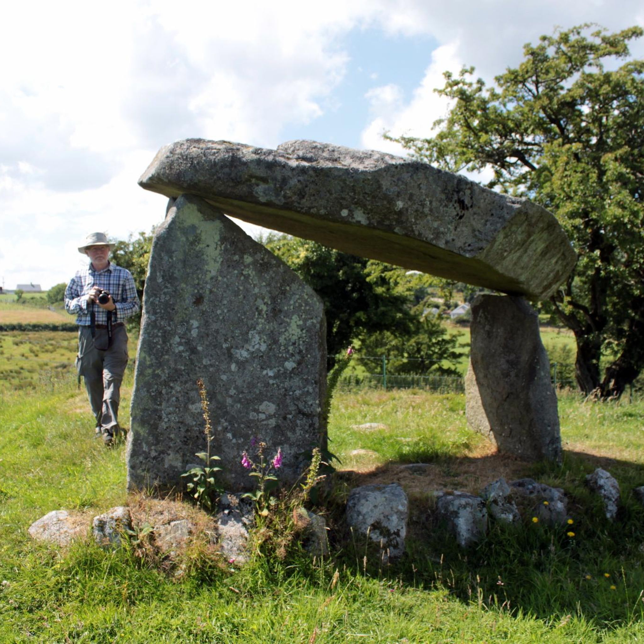
The Ballykeel Dolmen, also known as the "Witch's Chair", stands alone on the edge of a green river terrace and invites you to take a look back into the past. With its three supporting stones and the imposing capstone, over three metres long, the dolmen looks like a stone sculpture left behind by a long-forgotten culture. The simple but distinctive tripod shape is a testament to the archaic construction that attracted people to this place over 4000 years ago. Excavations around the dolmen have uncovered the remains of a stone mound and Neolithic pottery that tell of the rites and customs of this early community. When you stand among the stones, you feel the mystique of the place - a place that inspires the imagination then and now. Nearby you will find other megalithic structures such as the Portal Tomb of Aughadanove, which together reflect the rich archaeological heritage of the region.
1
0
In the middle of the forest, you suddenly find yourself standing in front of a bizarre stone creature - the "witch". She looks as if she has just risen from the mossy ground, with a mischievous smile and deep, expressive wrinkles on her face. This artfully designed stone is one of those unexpected encounters that transform the forest into a small adventure land. When you explore this magical place surrounded by old trees and whispering leaves, it almost seems as if the witch is greeting you with a wink. Here you can linger for a moment, enjoy the silence and let your imagination run wild - who knows what stories this forest still has to tell?
1
0
On the way through the Giant's Lair you will be immersed in Irish legends. As soon as you pass under the artistically carved archway, a magical world opens up in which the story of Finn McCool comes to life. The path leads you and the whole family through four chapters that bring the world of legend to life with lovingly designed stations. For the little ones it is an exciting treasure hunt - at every bend there are new clues waiting for them, which they eagerly discover. While they run ahead to find the next adventure, there is enough time for you to enjoy the lush nature. The dense trees, the mosses and the ancient carvings make you forget everyday life. You are in the middle of a story that unfolds further with every step.
1
0
As soon as you cross the gentle ridge of Slieve Gullion, the North Cairn stretches out before you - a slightly smaller hill than its southern neighbour, but no less impressive. The stones that gather here seem like silent sentinels, witnesses of the distant Bronze Age. Two ancient stone boxes were once found here during excavations, which lay hidden in the depths of history. The North Cairn, with its diameter of around 18 metres, invites you to pause for a moment and enjoy the peace. But it is not just the Cairn that is fascinating. Right next to it lies "Calliagh Beara's Lough", a quiet mountain lake that, according to legend, is the home of the witch Beara. On a clear day, the sky is reflected in the calm waters and you can almost feel the ancient magic of this place coming to life. The road here may be rocky, but the landscape rewards with sweeping views and a touch of mysticism that makes Slieve Gullion something special.
1
0

Cycle with caution, one way system in place for this small section
0
0


This small forest at the foot of Slieve Gullion seems to be straight out of a fairy tale. Running through it will leave you enchanted, and you'll come across curious sculptures like this giant witch's face.
0
0
Frequently Asked Questions
How many hiking trails are available around Ballykeel?
You can explore over 30 hiking routes around Ballykeel. The trails range from easy strolls through forest parks to challenging ascents in the Mourne Mountains, offering plenty of options for all fitness levels.
What do other hikers think of the trails in the Ballykeel area?
The trails around Ballykeel are highly regarded by the komoot community. Hikers often praise the stunning volcanic landscapes of the Ring of Gullion, the well-maintained paths in the forest parks, and the rich sense of history found along many routes.
Are there any easy walks suitable for families with children?
Yes, the region has several family-friendly options. A great choice is the Killeavy Castle & Slieve Gullion Forest Park loop, a gentle 4.2 km walk. For another popular spot with families, consider The Fairy Glen in Rostrevor, known for its enchanting riverside path.
Can I bring my dog on hikes near Ballykeel?
Many trails in the area are suitable for dogs, but it's important to check local rules. Forests like Cairn Wood are popular with dog walkers. Always keep your dog under control, especially near livestock, and be prepared for stiles on some country routes.
Are there any circular walks with good views?
The area is perfect for circular hikes with rewarding views. For a challenging mountain loop, consider the Slieve Gullion Summit – Calliagh Beara Lough loop from Drumintee. It's a 13.4 km route that rewards you with panoramic views from the summit.
What is the terrain like on the trails around Ballykeel?
The terrain is quite varied. You'll find quiet, paved country lanes on routes like The Poets' Trails, well-surfaced paths in forest parks such as Slieve Gullion Forest Park, and rugged, open mountainside with boggy sections in the higher Mournes. Waterproof footwear is recommended for most mountain hikes.
Are there any hikes that feature waterfalls?
Yes, you can find some beautiful waterfalls in the region. Glenariff Forest Park, a local favorite, is renowned for its Waterfall Walkway, which features a series of impressive cascades. Nearby Crawfordsburn Country Park also has a lovely waterfall accessible via a woodland walk.
What should I wear for hiking in the Ballykeel region?
It's best to dress in layers as the weather can change quickly, especially in the mountains. A waterproof jacket and trousers are essential. Sturdy, waterproof hiking boots are highly recommended for comfort and support on the varied and sometimes boggy terrain.
Where can I find parking for the main hiking trails?
Most popular trailheads have dedicated parking. Slieve Gullion Forest Park has a large car park, though it can get busy. For mountain hikes starting from minor roads, parking is often limited to small lay-bys, so it's best to arrive early to secure a spot.
Are there any trails that are good for a full day's hike?
Certainly. For a substantial day out, the Slieve Gullion loop from Forkhill Road is a great option. This 13.7 km moderate hike takes around 4.5 hours and includes a significant ascent, offering a rewarding challenge and fantastic views.
Can I access any trailheads using public transport?
Accessing trailheads directly via public transport can be challenging in this rural area. Bus services connect larger towns like Newry and Kilkeel, but you will likely need a taxi for the final leg to more remote starting points, such as those in the Mourne Mountains or Ring of Gullion.
What is the best time of year to hike around Ballykeel?
You can hike here year-round, but spring and summer (April to September) offer the best conditions with longer daylight hours and warmer weather. The landscape is particularly beautiful in late spring when the gorse is in bloom. Autumn provides stunning colours, but be prepared for more unsettled weather.
Most popular routes around Ballykeel
Most popular attractions around Ballykeel

Get inspired with the komoot mobile app


Explore more
Browse the best Hikes in other regions.
