The best road cycling routes in Clark County
4.7
(10)
337
riders
20
rides
Road cycling in Clark County, Ohio, offers a network of routes primarily characterized by its river valleys and scenic trails. The region features a mix of flat, paved paths along waterways and gentle rolling terrain through parklands. Cyclists can explore areas around the Little Miami River and Buck Creek, providing varied experiences for different skill levels.
Best road cycling routes in Clark County
- The most popular road cycling route is Stone Bridge Over the Pond – Five Rivers Fountain of…
Last updated: July 11, 2026
38
riders
83.9km
04:06
220m
220m
Moderate road ride. Good fitness required. Mostly well-paved surfaces and easy to ride.
5.0
(3)
39
riders
50.9km
02:28
160m
160m
Moderate road ride. Good fitness required. Mostly well-paved surfaces and easy to ride.

Sign up for free
18
riders
38.6km
02:16
140m
140m
Moderate road ride. Good fitness required. Some segments of this route may be unpaved and difficult to ride.
5.0
(1)
19
riders
48.2km
02:03
130m
130m
Moderate road ride. Good fitness required. Mostly well-paved surfaces and easy to ride.
11
riders
22.4km
01:13
80m
80m
Easy road ride. Great for any fitness level. Mostly well-paved surfaces and easy to ride.
5.0
(1)
9
riders
Moderate road ride. Good fitness required. Mostly well-paved surfaces and easy to ride.
8
riders
This road cycling loop around Wright-Patterson Air Force Base (Patterson Field) offers a pleasant and accessible ride, perfect for those who enjoy a mix of natural scenery and historical landmarks.…
11
riders
47.8km
02:06
170m
170m
Moderate road ride. Good fitness required. Mostly well-paved surfaces and easy to ride.
5.0
(1)
10
riders
27.4km
01:15
80m
80m
This easy 17.0-mile (27.4 km) road cycling loop, with a minimal 268 feet (82 metres) of elevation gain, offers a delightful ride through the Miami Valley. You'll pedal alongside the…
4
riders
The Creekside Trail – Glen Helen Nature Preserve loop from Hebble Creek Preserve offers a fantastic road cycling experience through a nature-filled corridor. You'll glide along mostly well-paved surfaces, enjoying…
Get access to more routes and recommendations from other explorers.
Sign up for free
Already have an account?
Our route recommendations are based on thousands of hikes, rides, and runs completed by other people on komoot.
Start today with a free account
Your next adventure awaits.
Login or Signup
Popular around Clark County

Road Cycling Routes around Park Layne

Road Cycling Routes around Enon

Road Cycling Routes around Holiday Valley

Road Cycling Routes around Green Meadows

Road Cycling Routes around Crystal Lakes

Road Cycling Routes around Medway

Road Cycling Routes around Springfield

Road Cycling Routes around Clifton

Road Cycling Routes in Buck Creek State Park
Little Miami Scenic Trail — A big adventure along the Little Miami River
Other adventures in Clark County

Tips from the Community

A very well-maintained park with beautiful hiking trails. There are parking spaces and shelters that can be rented for barbecues.
0
0

The Creekside Trail is a great 16-mile long trail that connects Dayton and Xenia. The trail is fully paved and is popular with walkers and cyclists. This section runs through several parks and green spaces, so it is a wonderful segment to ride.
0
0

A small village along the Little Miami Scenic Trail, with access to several attractions. Just under a mile northwest, you can find Waynesville, which is known as the “Antiques Capital of the Midwest” and the “Home of the Ohio Sauerkraut Festival.” About 3 miles southwest, you can find the gorgeous Caesar Creek State Park, which offers excellent hiking trails.
1
0

This 700-acre preserve was created from a gift of land to Antioch College by Hugh Taylor Birch to honor his daughter, Helen Birch Bartlett. Much of it is along the two creeks that flow by, and the trails access a number of picturesque waterfalls.
0
0


Here the paved Little Miami Scenic Trail crosses SR 350. There is a canoe rental and helpful signposts at the junction. If you head east along SR 350 you will come upon Fort Ancient, an early American archaeological site with trails and an overlook of the river.
1
0
The Wright Brothers Bikeway is an almost 5-mile long paved trail that runs through Fairborn. It is popular with cyclists and hikers, so make sure you are respectful of the other trail users.
1
0
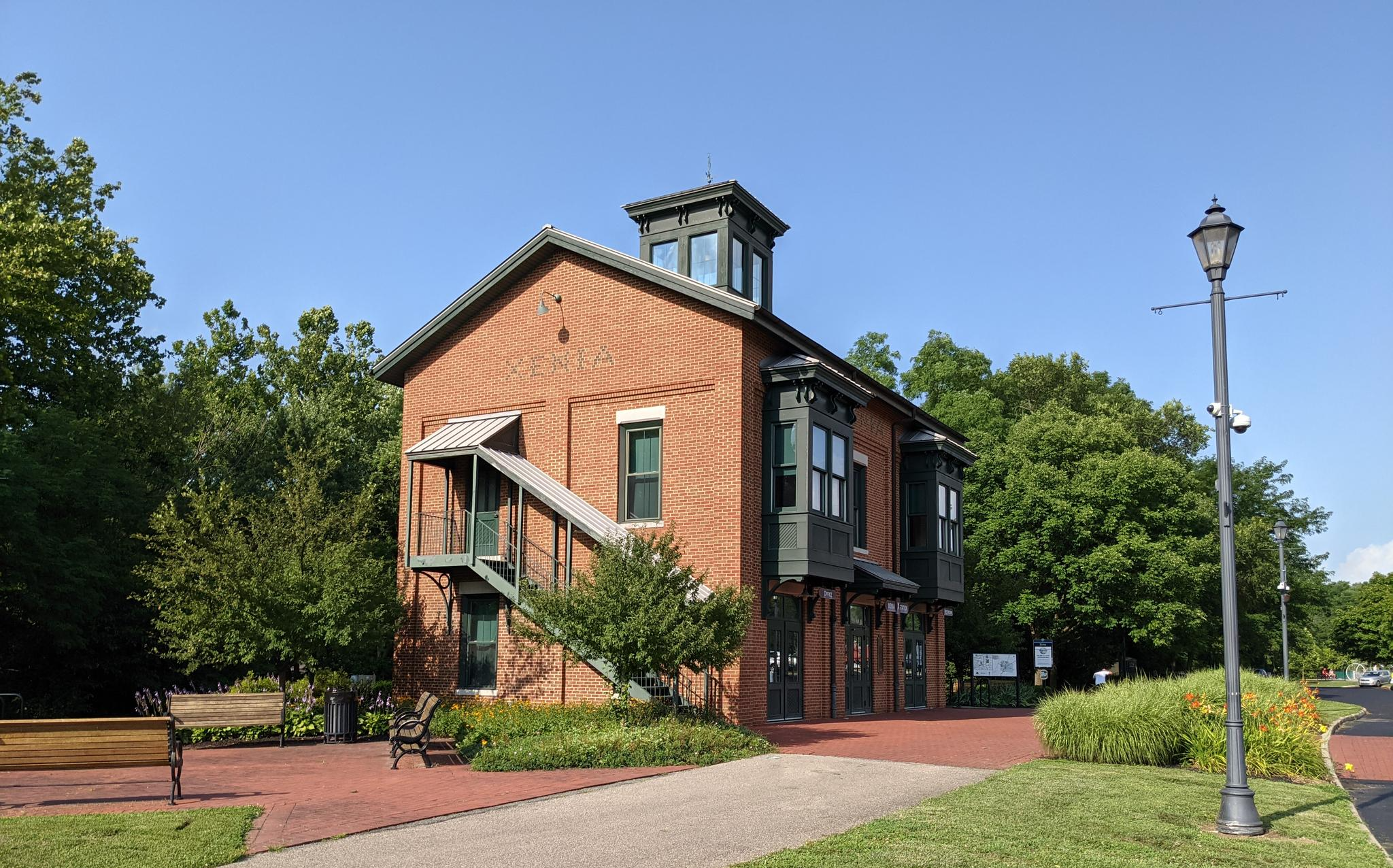
The Xenia Station is a replica of an old brick train station that used to be in the area. It now holds a museum and meeting space, and serves as a trail head for several trails that intersect at this point.
1
0
Frequently Asked Questions
How many road cycling routes are available in Clark County, Ohio?
Clark County, Ohio, offers over 20 dedicated road cycling routes. These routes provide a diverse range of experiences, primarily characterized by river valleys and scenic trails.
Are there road cycling routes suitable for beginners in Clark County, Ohio?
Yes, Clark County has several easy road cycling routes perfect for beginners. For example, the Roadbike loop from Buck Creek State Park is an easy 14-mile (22.5 km) ride, offering a gentle introduction to the area's trails.
What are some longer, more challenging road cycling routes in Clark County, Ohio?
For those seeking a greater challenge, routes like the Creekside Trail – Glen Helen Nature Preserve loop from Hebble Creek Preserve stand out. This moderate 53-mile (85.2 km) path features extensive trail riding and passes through natural preserves, offering a more demanding experience.
Are there any family-friendly road cycling options in Clark County, Ohio?
Many of the routes in Clark County, particularly those along the Little Miami River and Buck Creek, are suitable for families. The paved paths and gentle terrain make them accessible for various skill levels, including younger riders. Consider routes with shorter distances and minimal elevation gain for a pleasant family outing.
What kind of scenery can I expect on road cycling routes in Clark County, Ohio?
Road cycling in Clark County, Ohio, is defined by its picturesque river valleys, such as the Little Miami River, and serene parklands. You'll encounter lush green landscapes, tranquil waterways, and dedicated scenic trails that offer a refreshing escape into nature.
Are most road cycling routes in Clark County, Ohio, circular?
Yes, many of the popular road cycling routes in Clark County are designed as loops, allowing you to start and end at the same point. Examples include the Stone Bridge Over the Pond – Five Rivers Fountain of Lights loop from Fairborn and the Little Miami Scenic Trail loop from Wittenberg University.
What do other road cyclists enjoy most about road cycling in Clark County, Ohio?
The area is highly rated by the komoot community, with an average score of 5.0 stars. Reviewers often praise the well-maintained trails, the scenic beauty of the river valleys, and the variety of routes that cater to different abilities, making it a rewarding experience for many.
What is the best time of year for road cycling in Clark County, Ohio?
Spring, summer, and fall generally offer the most pleasant conditions for road cycling in Clark County. The weather is typically mild, and the natural scenery is vibrant. While winter cycling is possible, be prepared for colder temperatures and potential snow or ice on trails.
Are there facilities like cafes or restrooms along the road cycling routes?
While specific facilities vary by route, many trails in Clark County, especially those passing through towns or near parks, offer access to amenities like cafes, restaurants, and restrooms. It's always a good idea to check the route details or local maps for specific points of interest before you head out.
Is parking available at trailheads for road cycling routes in Clark County, Ohio?
Yes, most major trailheads and parks that serve as starting points for road cycling routes in Clark County offer designated parking areas. For instance, routes starting from Buck Creek State Park or near Wittenberg University typically have convenient parking options.
Can I access road cycling routes in Clark County, Ohio, using public transport?
Public transport options with bike access can vary. While some urban areas in Clark County may offer bus services with bike racks, it's best to check the specific routes and schedules of local public transportation providers like the Clark County Public Transit Department for details on bike accessibility to trailheads.
What is the average length of road cycling routes in Clark County, Ohio?
The road cycling routes in Clark County vary significantly in length. You can find shorter, easy loops around 14 miles (22.5 km), such as the Roadbike loop from Buck Creek State Park, up to longer, moderate rides like the Creekside Trail – Glen Helen Nature Preserve loop from Hebble Creek Preserve, which is about 53 miles (85.2 km).
Most popular routes in Clark County

Get inspired with the komoot mobile app


Didn’t find what you were looking for?
Check out more Road cycling routes throughout Clark County below and find the perfect route in your destination.
Explore more
Browse the best Road cycling routes in other regions.
