Attractions and Places To See around Area A (Wells Gray Country) - Top 20
Best attractions and places to see around Area A (Wells Gray Country) are centered around the vast wilderness of Wells Gray Provincial Park, a region renowned for its natural beauty. This area features over 40 named waterfalls, pristine lakes, and unique volcanic landscapes. It also holds significant cultural heritage, with archaeological sites dating back approximately 5,000 years. The diverse geography offers a wide range of outdoor experiences for visitors.
Best attractions and places to see around Area A (Wells Gray…
Last updated: September 26, 2026
Moul Falls
Highlight • Waterfall
Translated by Google •
Tip by

Spahats Creek Falls
Highlight • Waterfall
Tip by

Sign up now to discover places like this
Get recommendations on the best single tracks, peaks, & plenty of other exciting outdoor places.
Dawson Falls
Highlight • Waterfall
Tip by
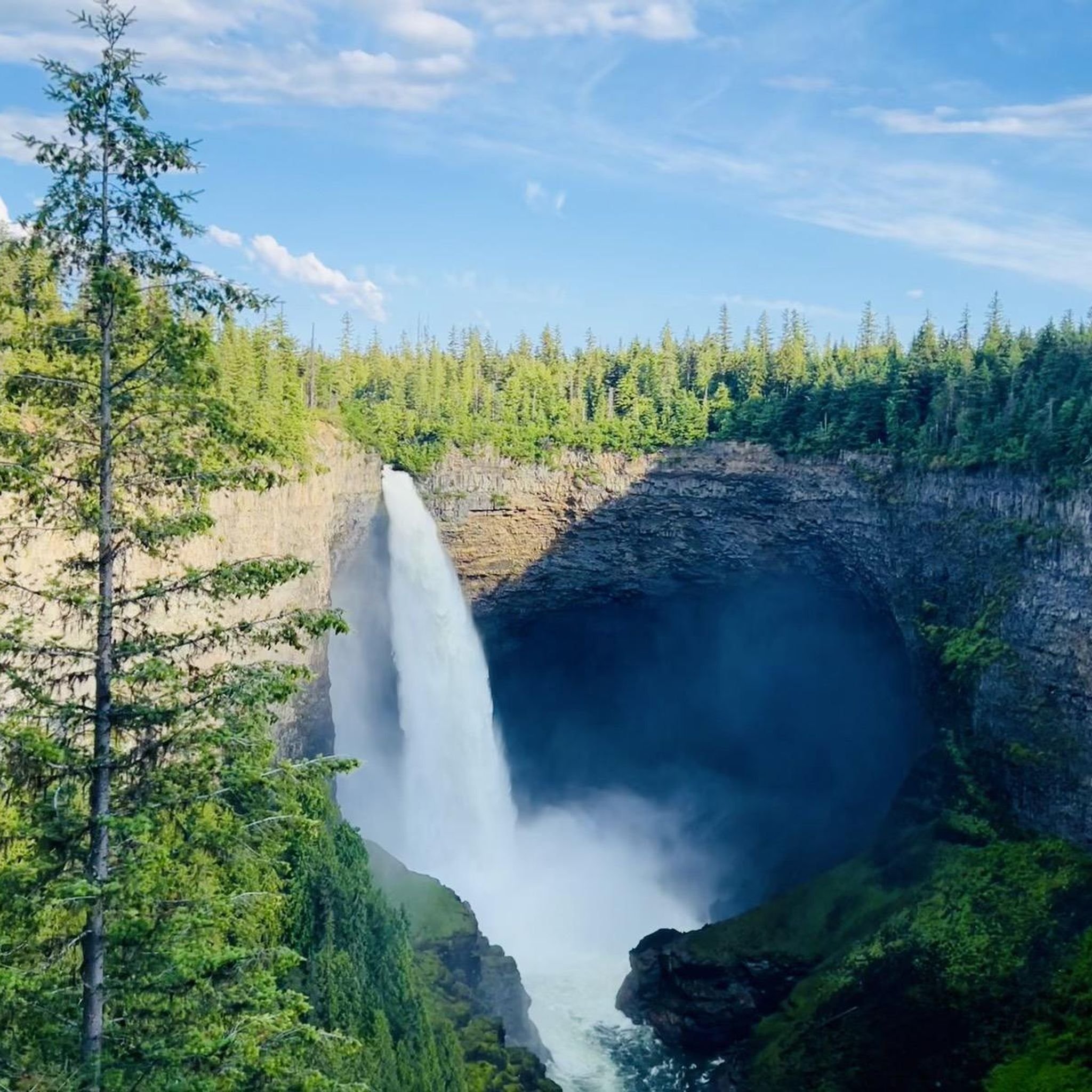
View of Helmcken Falls
Highlight • Waterfall
Showing Translation
Tip by

The Mushbowl
Highlight • Waterfall
Tip by
Sign up for free to discover even more attractions around Area A (Wells Gray Country).
Already have an account?
Start today with a free account
Your next adventure awaits.
Popular around Area A (Wells Gray Country)
Tips from the Community

At over 140 metres tall, it's easy to see why Helmcken Falls was one of the main reasons for the formation of Wells Gray Provincial Park. While the spectacular waterfall is a main draw during the busy summer season, the area is also popular with ice climbers during winter and the falls are known as the "Yosemite of ice climbing".
1
0

Here you can really disappear into nature.
3
0
A tough climb, but really cool.
3
0
So incredibly cool! You don't want to miss this.
3
0

It's definitely worth it, especially early in the morning when there aren't many people there yet.
1
0


From the Dawson Falls parking lot, a trail along the Murtle River takes you to the Falls in about 10 minutes. About two-thirds of the way, there is an excellent viewing point for the Falls. The water of the Murtle River plunges about 18 meters down a step at Dawson Falls. If you're lucky, you can see a rainbow below the Dawson Falls. Opposite is another observation point; it can be reached from the Pyramid Campground. In addition to Dawson Falls, there are six other waterfalls along the Murtle River in Wells Gray Park. (Visit June 3, 2018) https://www.worldwaterfalldatabase.com/waterfall/Dawson-Falls-2305 https://en.wikipedia.org/wiki/Dawson_Falls
2
0
Spahats Creek flows west from the Trophy Mountains, crossing the area's basalt formation. Upstream of Spahats Creek Falls, the creek has carved itself into a 23-meter-deep gorge and then plunges over the waterfall 61 meters into a massive canyon, emptying into the Clearwater River a few hundred meters later. The canyon is the result of glacial meltwater that flowed over the edge of the Clearwater Valley about 11,000 years ago. After the Ice Age, the stream receded into the comparatively small Spahats Creek. Spahats Creek was once known as Bear Creek. Spahats is a native word for bear. (Visit June 3, 2018) https://www.worldwaterfalldatabase.com/waterfall/Spahats-Creek-Falls-2293
3
0
Frequently Asked Questions
What are some of the most impressive waterfalls to visit in Wells Gray Country?
Wells Gray Country is famously known as "Canada's Waterfall Park." Among the most impressive are Helmcken Falls, Canada's fourth-highest waterfall plunging 141 meters; Spahats Creek Falls, which drops 61 meters into a massive canyon; and Dawson Falls, a wide and picturesque waterfall on the Murtle River. You can even walk behind Moul Falls for a unique perspective.
Are there family-friendly attractions and activities in Wells Gray Country?
Yes, many attractions in Wells Gray Country are suitable for families. Waterfalls like Spahats Creek Falls, Helmcken Falls, and Dawson Falls offer accessible viewing platforms and short walks. The region also provides opportunities for easy hikes, canoeing, kayaking, and wildlife viewing, making it an excellent destination for all ages.
What kind of hiking trails can I find around Wells Gray Country?
Wells Gray Country offers a wide range of hiking trails, from short, easy walks to multi-day backcountry adventures. You can find easy waterfall hikes like the loop to Moul Falls or the trail to Dawson Falls. For more options, explore the various hiking routes available in the region, including those found in the Easy hikes around Area A (Wells Gray Country) guide.
What unique natural features, beyond waterfalls, can I explore?
Beyond its famous waterfalls, Wells Gray Country boasts pristine lakes like Clearwater Lake and Azure Lake, ideal for canoeing and kayaking, and Murtle Lake, North America's largest paddle-only lake. The region also features unique volcanic formations, including extinct volcanoes and lava beds, and the spectacular Trophy Mountain Flower Meadows, Canada's largest sub-alpine flower meadow.
Are there any historical or cultural sites to visit in the area?
Yes, Wells Gray Country has a rich cultural heritage. The region is the traditional territory of several First Nations, with approximately 50 aboriginal sites identified within the park, some dating back about 5,000 years. You can also visit the abandoned Ray Farm, a significant historical site from 1911 that showcases the early pioneering spirit of settlers.
What is the best time of year to visit Wells Gray Country, especially for waterfalls?
The best time to visit Wells Gray Country for its waterfalls and lush landscapes is generally from late spring to early fall (May to October). During spring and early summer, glacial meltwater ensures the waterfalls are at their most powerful. Late summer and fall offer opportunities to see salmon attempting to jump Bailey's Chute.
Can I go whitewater rafting or other water sports in Wells Gray Country?
Yes, the Clearwater River, a glacier-fed river central to Wells Gray Provincial Park, is a popular spot for whitewater rafting. Additionally, the numerous lakes like Clearwater Lake, Azure Lake, and Murtle Lake are perfect for canoeing, kayaking, and stand-up paddleboarding.
Where can I find panoramic views of the Wells Gray Country landscape?
For breathtaking panoramic views, consider visiting the Green Mountain Viewing Tower, which offers 360-degree vistas of the entire valley, including mountains, ranges, and even volcanoes. Shaden Viewpoint also provides spectacular views of the Clearwater River valley and is a great spot for a picnic.
What kind of wildlife can I expect to see in Wells Gray Country?
Wells Gray Provincial Park is home to a diverse array of wildlife. Visitors often spot black bears, grizzly bears, moose, deer, caribou, and various bird species, including eagles. The Ray Farm area is also known as an excellent spot for wildlife viewing.
Are there specific trails for waterfall hikes in Wells Gray Country?
Absolutely. Wells Gray Country is renowned for its waterfall trails. You can find dedicated routes like the Moul Falls loop, the Dawson Falls loop, and the Spahats Creek Falls loop. For a comprehensive list of trails focused on waterfalls, refer to the Waterfall hikes around Area A (Wells Gray Country) guide.
What are some options for winter activities in Wells Gray Country?
While famous for its summer attractions, Wells Gray Country also offers winter activities. Opportunities exist for snowshoeing, cross-country skiing, and ski-touring, with a network of trails and chalets available for winter enthusiasts.
What makes Spahats Creek Falls unique?
Spahats Creek Falls is unique because it plunges 61 meters into a massive canyon that was carved by glacial meltwater over 11,000 years ago. The canyon itself is a testament to the area's geological history, showcasing the power of ancient ice and water.
What is special about Moul Falls?
Moul Falls, a 35-meter-high waterfall on Grouse Creek, offers a unique experience as visitors can walk behind the cascade. This provides an immersive and memorable perspective of the falling water, though you might get splashed by the spray!
Most popular routes around Area A (Wells Gray Country)
Most popular attractions around Area A (Wells Gray Country)

Get inspired with the komoot mobile app


Explore more
Still not found the Highlight you’re looking for? See guides of the top attractions in other regions:
