The best walks and hikes around Indio Hills
4.7
(16)
216
hikers
12
hikes
Hiking around Indio Hills explores a desert landscape shaped by the San Andreas Fault. The region features eroded badlands, sandy washes, and palm oases sustained by natural springs. Trails navigate through a mix of narrow canyons and ridges, offering views across the Coachella Valley. This unique topography provides diverse hiking environments, from dramatic geological formations to lush palm groves.
Best hiking trails around Indio Hills
- The most popular hiking route is Indio Hills Badlands loop — Indio, California, a 5.1 miles (8.2 km) trail that takes 2 hours 18 minutes to complete. This route features ascents to ridges with expansive views of the surrounding badlands.
- Another top favourite among local hikers is Pushwalla Palms Loop, a difficult 7.5 miles (12.1 km) path. The trail leads through sandy washes and palm groves, showcasing the area's unique geology.
- Local hikers also love the Moon Country and McCallum Trail Loop, a 4.0 miles (6.4 km) trail leading through the Coachella Valley Preserve, often completed in about 1 hour 42 minutes.
- Hiking around Indio Hills is defined by eroded badlands, sandy washes, and palm oases. The trail network offers options for different ability levels, from easy walks in the preserve to more challenging routes through the hills.
- The routes in Indio Hills are highly rated by the komoot community with an average score of 4.8 stars from over 10 reviews. More than 220 hikers have used komoot to explore Indio Hills's varied terrain.
Last updated: October 3, 2026
4.5
(2)
34
hikers
12.1km
03:28
240m
240m
The Pushwalla Palms Loop offers a fascinating journey through a desert landscape shaped by the San Andreas Fault, where arid terrain suddenly gives way to lush palm oases. You'll traverse a tan-colored bluff, follow an exposed ridgeline with continuous views of the San Jacinto and San Bernardino Mountains, and navigate through washes and slot canyons. The trail's highlight is discovering the vibrant Pushawalla Palms oasis and Horseshoe Palms oasis, sustained by underground water, creating a striking contrast against the dramatic cliffs of soft sediment.
This difficult 7.5 miles (12.1 km) hike involves 798 feet (243 metres) of elevation gain and takes approximately 3 hours and 28 minutes, making it suitable for hikers in good physical condition. Due to the desert heat and lack of shade, it's best to hike between October and May, and always carry ample water, wear a sunhat, and use sunscreen. Remember that dogs are not allowed on this trail.
What truly sets this route apart is its direct connection to the San Andreas Fault system; seismic activity pushes groundwater to the surface, allowing these improbable palm oases to flourish in an otherwise barren environment. Keep an eye out for wildlife, including the endangered fringe-toed lizard, as you explore this unique geological wonder within the Coachella Valley Preserve.
5.0
(1)
5
hikers
2.95km
00:50
70m
70m
The Willis Palms Loop Trail offers a truly unique desert experience, taking you directly through one of the largest native fan palm oases in the Coachella Valley. Imagine walking from arid desert into a lush, jungle-like environment, all thanks to groundwater brought to the surface by the San Andreas Fault. This easy 1.8-mile (3.0 km) hiking loop, with just 219 feet (67 metres) of elevation gain, provides panoramic views of the Coachella Valley and showcases fascinating red fault gouge hills, making it a perfect quick escape into a geologically active landscape that takes around 50 minutes.
For the best experience, plan your visit between October and May to avoid the intense summer heat. Always remember to bring plenty of water and wear sun protection, as the desert sun can be quite strong. While the trail is easy, some sections have varied terrain, so comfortable hiking shoes are recommended. Arriving earlier in the day can also help you find parking more easily and enjoy cooler temperatures.
What makes this trail particularly special is its direct connection to the San Andreas Fault system; you literally walk on it, witnessing how tectonic activity has shaped the Indio Hills and created the conditions for the vibrant palm oases. The area is also rich in Sonoran biodiversity and holds historical significance for the Cahuilla Indigenous tribes, who utilized the fan palms. It's a living testament to the desert's resilience and geological power.

1.05km
00:16
10m
10m
The Múmawet Hill trail offers a unique blend of desert beauty and deep cultural significance, making it a standout short hike in the Coachella Valley. You'll traverse soft sandy paths and some unpaved hard-pack sections, leading to a hilltop that provides sweeping panoramic views of the Thousand Palms Canyon. It's a quick, accessible way to immerse yourself in the desert's ecosystem and history, perfect for a family outing or a peaceful moment of reflection.
This easy 0.7-mile (1.1 km) out-and-back route involves only 19 feet (6 metres) of elevation gain, taking approximately 16 minutes to complete. The trail is largely exposed to full sun, so plan your visit for cooler parts of the day or season, and always bring water. Parking is available at the Thousand Palms Oasis Preserve, which serves as the trailhead for this culturally rich path.
Beyond its natural beauty, Múmawet Hill holds immense importance as the site of the ancient Cahuilla village of Yum Ich You, a heritage honored by its recent renaming. The surrounding preserve is a critical habitat for endangered species like the Coachella Valley fringe-toed lizard, and its geology is shaped by the San Andreas Fault, contributing to the unique oasis environment. It's a fantastic spot for Múmawet Hill wildlife spotting and appreciating the desert's delicate balance.
4.9
(7)
93
hikers
8.20km
02:19
170m
170m
The East Indio Hills Badlands Trail offers a captivating journey through a desert landscape dramatically shaped by geological forces. As you hike, you'll encounter a fascinating mix of sandy washes, rocky paths, and narrow slot canyons, leading to ridge tops with incredible 360-degree panoramic views of the Coachella Valley and surrounding mountains. The scenery is characterized by unique rock formations, including fluted ridges and hoodoos, making for a visually engaging experience.
This moderate 5.1 miles (8.2 km) loop, with 566 feet (173 metres) of elevation gain, typically takes around 2 hours and 18 minutes to complete. It's best enjoyed during the cooler months, from October through April, as there's minimal shade along the route. Always bring ample water and sun protection, and be aware that flash flooding can occur during heavy rains. Parking is available at the trailhead, making access relatively easy.
What truly sets this trail apart is its direct connection to the San Andreas Fault, showcasing uplifted and eroded sedimentary rock that tells a story millions of years old. The presence of engaging slot canyons and wind caves adds to its distinctiveness, reminiscent of other iconic desert parks. It's a fantastic way to experience the raw power of nature and witness unique geological features up close.
4.3
(3)
23
hikers
3.40km
01:03
120m
110m
Hike the easy 2.1-mile Inspiration Peak Trail in Joshua Tree National Park for panoramic views of the Coachella Valley and surrounding mount
Get access to more routes and recommendations from other explorers.
Already have an account?
Our route recommendations are based on thousands of hikes, rides, and runs completed by other people on komoot.
Start today with a free account
Your next adventure awaits.
Popular around Indio Hills

Tips from the Community

Hikers moving clockwise will begin Indio Badlands Trail on this western section, which introduces hikers to the San Andreas fault and several slot-canyons on the way to the top.
1
0
This is the high point of Indio Hills Badlands Trail, and though completely devoid of shade, it makes a worthwhile spot to pause and take in the dramatic geology below and around you.
1
0

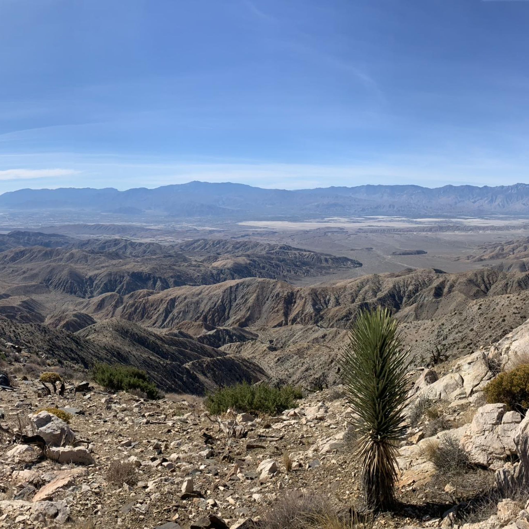
This popular destination, perched on the crest of the Little San Bernardino Mountains, provides panoramic views of the Coachella Valley and is well worth the 20-minute drive from Park Boulevard down Keys View Road. https://www.nps.gov/jotr/planyourvisit/keysview.htm
0
0

Frequently Asked Questions
Are dogs allowed on the trails in Indio Hills?
Most trails in the Indio Hills area, particularly within the Coachella Valley Preserve and the Indio Hills Badlands, are not dog-friendly to protect the sensitive ecosystem and wildlife, including the endangered fringe-toed lizard. It's always best to check the specific regulations for each trailhead before you go, but generally, you should plan to leave your dog at home for these hikes.
What are some good easy or family-friendly hikes in the Indio Hills?
The Coachella Valley Preserve is an excellent choice for an easier outing. It features several relatively flat trails through unique palm oases. The Hidden Palms Trail loop is a gentle 2-mile (3.2 km) walk. Another great option is the trail to McCallum Pond, which is a tranquil spot fed by natural springs.
What is the terrain like on the Indio Hills trails?
The terrain is classic desert hiking shaped by the San Andreas Fault. Expect a mix of sandy washes, rocky paths, and climbs up eroded badlands. Some routes, like the popular Indio Hills Badlands loop, feature narrow slot canyons and ascents to ridges with panoramic views. Sturdy footwear is essential.
Is there parking available at the trailheads?
Yes, there is parking available, but it can be limited, especially on weekends. The main Indio Hills Badlands Trailhead is located at the end of Golf Center Parkway and has a designated parking area. For hikes within the Coachella Valley Preserve, there is parking near the visitor center on Thousand Palms Canyon Road. Arriving early is recommended to secure a spot.
Can I get to the Indio Hills trails using public transport?
Reaching the trailheads in the Indio Hills and the Coachella Valley Preserve via public transportation is very difficult. The trailheads are located in remote areas away from public bus routes. The most practical way to access the hikes is by car.
Are there any circular walks available?
Yes, many of the best hikes in the area are loops. The McCallum Pond & Moon Country loop is a 4-mile (6.4 km) circular route that offers a fantastic tour of the preserve. For a more challenging loop, the Pushwalla Palms loop from Desert Palms is a difficult 5.3-mile (8.5 km) trail that takes you through sandy washes and palm groves.
What makes the landscape of the Indio Hills so unique?
The dramatic scenery is a direct result of the San Andreas Fault. The movement of tectonic plates has uplifted and folded the soft sediment, creating the stunningly eroded badlands, ridges, and canyons you see today. This same geological activity forces groundwater to the surface, which is why lush palm oases can thrive in the middle of the arid desert.
Are there any waterfalls in or near the Indio Hills?
While the Indio Hills themselves are characterized by dry washes and oases, you can find a seasonal waterfall nearby. Tahquitz Canyon, a short drive away in Palm Springs, features a popular trail leading to a 60-foot waterfall, offering a different kind of desert hiking experience.
What should I wear and bring for a hike in Indio Hills?
For hiking in this desert environment, preparation is key. Wear lightweight, breathable clothing and sturdy hiking shoes with good grip for the sandy and rocky terrain. Sun protection is crucial, so bring a wide-brimmed hat, sunglasses, and sunscreen.
Most importantly, carry more water than you think you'll need, as there are no water sources on the trails. Also, pack some salty snacks to help with hydration.
What do other hikers say about the trails around Indio Hills?
The trails around Indio Hills are highly regarded by the komoot community, with an average rating of 4.8 out of 5 stars. Hikers often praise the otherworldly landscapes of the badlands, the unique experience of walking through palm oases, and the rewarding panoramic views from the ridges.
What are some popular places for hiking in the Indio Hills area?
Besides the main badlands trail, the Coachella Valley Preserve - Thousand Palms Oasis Preserve is a major hub for hiking, known for its accessible trails and unique palm groves. For a different experience, many people visit Tahquitz Canyon to see its seasonal waterfall. The vast Santa Rosa and San Jacinto Mountains National Monument also offers extensive backcountry trails for more ambitious adventures.
How do the Indio Hills compare to the Mecca Hills for hiking?
Both areas offer incredible badlands scenery shaped by the San Andreas Fault. The Indio Hills are generally more accessible, with trailheads right at the edge of the city of Indio. The Mecca Hills, particularly the Ladder Canyon trail, are more remote and can require a 4x4 vehicle to reach the trailhead, offering a more rugged and adventurous experience.
Most popular routes around Indio Hills
Most popular attractions around Indio Hills

Get inspired with the komoot mobile app


Explore more
Browse the best Hikes in other regions.
