The best cycling routes around Marble Cliff
4.6
(100)
945
riders
55
rides
Touring cycling routes around Marble Cliff are characterized by a network of paved trails along the Olentangy and Scioto Rivers. The region features a blend of urban landscapes, riverside woods, and green spaces. Terrain is generally flat to gently rolling, with minimal significant elevation changes. The area provides accessible routes suitable for various cycling abilities.
Best touring cycling routes around Marble Cliff
- The most popular touring cycling route is Olentangy River Trail – Antrim Lake Deck loop from Upper Arlington…
Last updated: October 5, 2026
5.0
(8)
74
riders
57.3km
03:14
130m
130m
Moderate bike ride. Good fitness required. Mostly paved surfaces. Suitable for all skill levels.
5.0
(3)
21
riders
35.2km
02:00
110m
110m
Moderate bike ride. Good fitness required. Mostly paved surfaces. Suitable for all skill levels.

4.3
(8)
31
riders
Easy bike ride. Great for any fitness level. Mostly paved surfaces. Suitable for all skill levels.
5.0
(1)
21
riders
13.7km
00:49
40m
40m
Easy bike ride. Great for any fitness level. Mostly paved surfaces. Suitable for all skill levels.
5.0
(1)
9
riders
29.8km
01:42
100m
100m
Easy bike ride. Great for any fitness level. Mostly paved surfaces. Suitable for all skill levels.
Get access to more routes and recommendations from other explorers.
Already have an account?
Our route recommendations are based on thousands of hikes, rides, and runs completed by other people on komoot.
Start today with a free account
Your next adventure awaits.
Popular around Marble Cliff


Tips from the Community

This paved multiuse trail is one of the most popular in Columbus. It provides a great transportation corridor along the Olentangy River, linking users up with neighborhoods, recreation opportunities, local businesses, and the simple opportunity to enjoy some time by the water.
0
0

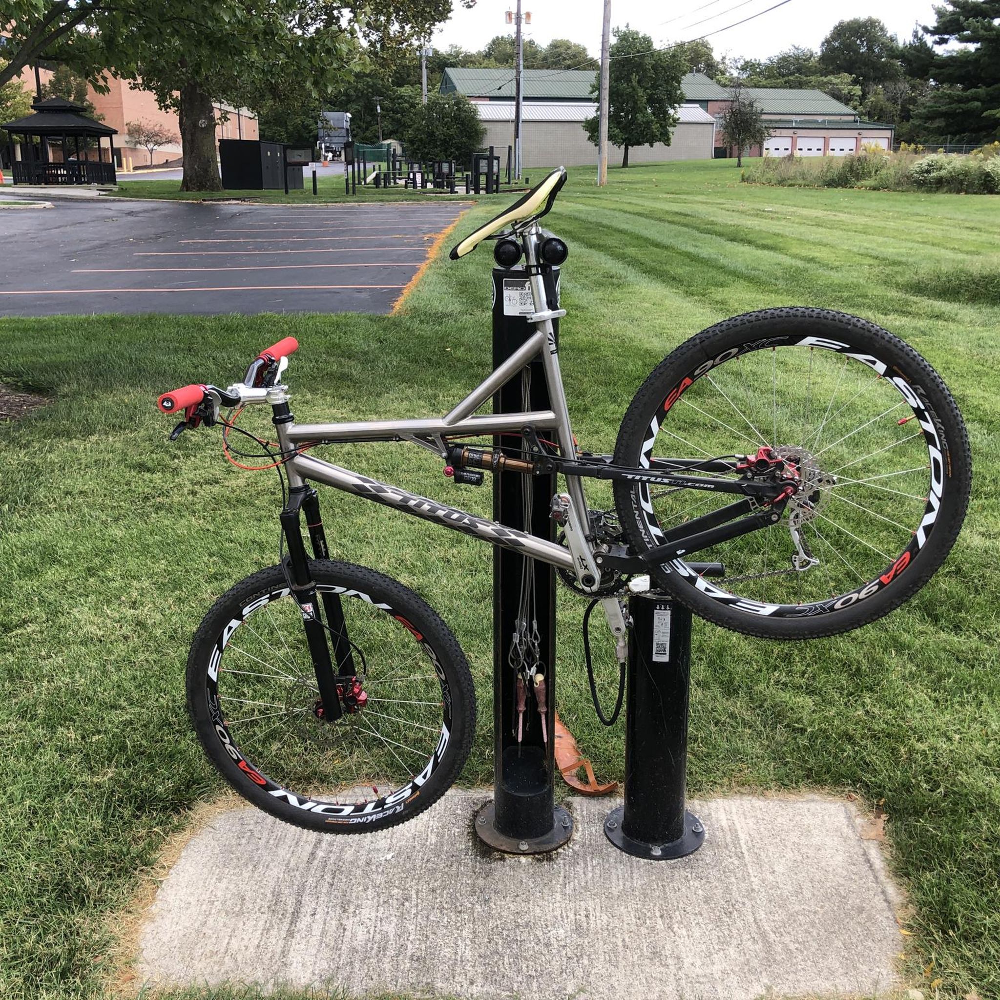
You’ll find this convenient bike repair station along the Scioto Trail, with a pump and tools available.
1
0

The Scioto Trail runs through the heart of downtown Columbus along the Scioto River. The trail is almost 7 miles long and is completely paved.
0
0

With the sparkling water in front of you and the city skyline in the background, this is a great place to stop and take in the view. It's especially great on calm, clear nights when the city lights reflect of the water.
0
0
Scioto Trail is a flat, paved route that runs along the Scioto River, with a nice view of the city skyline and West Broad Street Bridge. The trail connects downtown Columbus with nearby parks and has multiple access points.
1
0

Wilson Road Park, a 47.5-acre regional park in the Hilltop community, offers an easy access point to the Camp Chase Trail and over 125 miles of regional trails, including the Ohio to Erie Trail. Built in 2017, the park features athletic fields, a paved path, an open-air shelter with picnic tables, bike racks, a water fountain, and a bike-repair station, making it a popular stop for cyclists, walkers, and runners.
0
0
The Olentangy River reaches 97 miles from Morrow County through Delaware County to Columbus, where it meets the Scioto at Confluence Park. Originally called "Keenhongsheconsepung," meaning "sharp tool river," settlers renamed it "Whetstone River" before a legislative mix-up in 1833 assigned it the name "Olentangy." The river serves as a drinking water source for Delaware County, while the Delaware State Park Reservoir is used for flood control. Restoration efforts, including dam removals, have reduced the river’s width and improved ecology.
0
0
The Camp Chase Trail is a 16-mile rail trail connecting Madison County to Columbus, Ohio, and forms part of the Ohio to Erie Trail and U.S. Bicycle Route 50. Starting at the Wilson Road SE trailhead, it changes from rural farmlands and prairies to urban landscapes, with highlights like Battelle Darby Creek Metro Park with its bison herd and the historical Fort Ancient mound. This ADA-compliant trail provides opportunities for walking, biking, and cross-country skiing in winter.
0
0
Frequently Asked Questions
What is the general terrain and difficulty level for touring cycling routes around Marble Cliff?
The touring cycling routes in Marble Cliff are generally flat to gently rolling, with minimal significant elevation changes. This makes them suitable for various cycling abilities. There are 32 easy routes, 12 moderate routes, and 1 difficult route available.
Are there any family-friendly touring cycling routes in the Marble Cliff area?
Yes, many routes are suitable for families. The region's network of paved trails along the Olentangy and Scioto Rivers offers accessible and generally flat paths. An easy option is the Scioto Audubon Metro Park – Scioto Trail loop from Columbus, which is 11.6 km long and takes about 43 minutes.
What natural features or landmarks can I expect to see along the touring cycling routes?
You'll encounter diverse natural features and landmarks. Routes often follow the Olentangy River, known for its interesting shale formations, and the Scioto River. You might also pass by the Scioto River Bridge and the Scioto Audubon Metro Park, a transformed industrial zone now a green space with river views. Quarry Trails Metro Park, built on a historic quarry, features Millikin Falls and limestone cliffs, though its trails are primarily for hiking and mountain biking.
Are there any long-distance touring cycling options connecting to larger networks?
Yes, the region is well-connected. The Camp Chase Trail, a 16-mile rail trail, is an integral part of the larger Ohio to Erie Trail and U.S. Bicycle Route 50. This provides opportunities for much longer excursions beyond the immediate Marble Cliff area, often on traffic-free paths through diverse landscapes.
What is the best time of year to go touring cycling around Marble Cliff?
Spring, summer, and fall generally offer the most pleasant conditions for touring cycling in Marble Cliff. The paved trails are accessible year-round, but warmer months provide lush scenery along the rivers and comfortable temperatures. Always check local weather forecasts before heading out.
Are there any routes suitable for beginner touring cyclists?
Absolutely. Many routes are classified as easy, making them perfect for beginners. For instance, the Scioto Trail – Olentangy River loop from Grandview Heights is an easy 23.5 km path offering a mix of urban and riverside scenery. Another easy option is the Olentangy River – Olentangy Trail loop from Grandview Heights, spanning 29 km.
Where can I find parking or public transport access for the cycling routes?
Many routes start near accessible points. For example, the Olentangy River Trail – Antrim Lake Deck loop starts from Upper Arlington High School, which likely offers parking. The Olentangy River – Scioto River Bridge loop starts from The Ohio State University, an area with various parking and public transport options. It's advisable to check specific starting points for detailed parking information.
What do other touring cyclists enjoy most about cycling in Marble Cliff?
The area is highly rated by the komoot community, with an average score of 4.6 stars from over 70 reviews. Cyclists often praise the extensive paved river trails, urban greenways, and the blend of urban and natural scenery. The accessibility for different ability levels and connections to larger regional networks are also frequently highlighted.
Are there any cafes or places to stop for refreshments along the routes?
Given the routes often pass through urban sections and areas like Grandview Heights and near The Ohio State University, you'll find various cafes, restaurants, and amenities nearby. Marble Cliff itself has a charming 'village atmosphere' with local establishments. It's recommended to check specific route maps for points of interest along your chosen path.
Are there any routes that offer views of the Olentangy River's shale formations?
Yes, routes that closely follow the Olentangy River are your best bet. The Olentangy River Trail, which is part of several loops like the Olentangy River Trail – Antrim Lake Deck loop, winds along the river and provides opportunities to see these unique geological features.
How many touring cycling routes are available in the Marble Cliff area?
There are over 45 touring cycling routes available around Marble Cliff, offering a wide variety of options for different distances and difficulty levels.
Most popular routes around Marble Cliff
Most popular attractions around Marble Cliff

Get inspired with the komoot mobile app


Explore more
Browse the best Cycling routes in other regions.
