The best walks and hikes in Lassen Volcanic Wilderness
4.8
(200)
2,587
hikers
70
hikes
Hikes in Lassen Volcanic Wilderness lead through a landscape shaped by volcanic activity. The region is characterized by its hydrothermal features, such as mud pots and boiling springs, alongside numerous alpine lakes and forested areas. Trails range from paths around volcanic cones to routes that ascend to mountain summits, offering varied hiking experiences.
Best hiking trails in Lassen Volcanic Wilderness
- The most popular hiking route is Kings Creek Horse Trail to Kings Creek Falls – Lassen Volcanic National Park, a 2.5 mile (4.0 km) trail that takes about 1 hour 25 minutes to complete. This moderate route leads hikers to the notable Kings Creek Falls.
- Another top favourite among local hiking enthusiasts is Brokeoff Mountain Trail to Brokeoff Mountain – Lassen Volcanic National Park, a moderate 6.9 mile (11.1 km) path. The trail involves a significant ascent to the summit of Brokeoff Mountain.
- Local hiking enthusiasts also love the Terrace, Shadow, and Cliff Lakes Trail out & back – Lassen Volcanic National Park, a 3.4 mile (5.5 km) trail leading through a series of alpine lakes, often completed in about 1 hour 45 minutes.
- Hiking in Lassen Volcanic Wilderness is defined by its volcanic peaks, hydrothermal areas, and high-elevation lakes. The trail network provides routes suitable for different ability levels, from short walks to more strenuous mountain hikes.
- The routes in Lassen Volcanic Wilderness are highly rated by the komoot community with an average score of 4.7 stars from over 170 reviews. More than 2,200 hikers have used komoot to explore Lassen Volcanic Wilderness's varied terrain.
Last updated: July 8, 2026
8
hikers
6.35km
01:59
190m
210m
Embark on the Kings Creek Falls, Bench Lake and Sifford Lakes Loop for a moderate hike through Lassen Volcanic National Park. This route spans 3.9 miles (6.4 km) and involves a total elevation gain of 609 feet (186 metres), typically taking around 1 hour and 59 minutes to complete. You will experience varied landscapes, from picturesque meadows to shaded fir and redwood forests, with the dramatic Kings Creek Falls as a highlight where water rushes through a narrow stone chasm.
When planning your visit, be aware that the trail includes a fairly steep descent with loose gravel and rocky sections, especially as you approach Kings Creek Falls. The cascades also feature large, potentially slippery stone steps, so wearing sturdy hiking boots is a good idea. Always check the Lassen Volcanic National Park website for current trail conditions before you go, as parts of the route have been closed in the past due to hazardous conditions.
Beyond the impressive falls, you can discover the tranquil waters of Bench Lake and the serene cluster of Sifford Lakes, offering peaceful forest vistas. Keep an eye out for local wildflowers like Fawn Lilies and Satin-leaf Lupines, and listen for the calls of Clark's Nutcrackers. This loop provides a diverse experience, showcasing the natural beauty and varied ecosystems of the park.
3
hikers
2.74km
00:50
120m
60m
The Mill Creek Falls Trail is a fantastic, easy 1.7-mile (2.7 km) hike in Lassen Volcanic National Park, offering a rewarding 50-minute journey with 401 feet (122 metres) of elevation gain. This route winds through diverse terrain, from red fir forests to open hillsides dotted with wildflowers like mule ears, culminating in the impressive 75-foot Mill Creek Falls, the park's tallest waterfall. You'll navigate dips, rises, and rocky sections, enjoying views of Brokeoff Mountain and Mt. Diller along the way.
To start your adventure, head to the Kohm Yah-mah-nee Visitor Center, where the trailhead is located behind the amphitheater. While the trail is generally considered easy, wearing sturdy hiking boots is advisable for the varied terrain. Remember to bring plenty of water, especially on sunny days, as some parts of the trail are exposed. This trail offers a less crowded alternative to some of the park's more popular spots, making it ideal for a peaceful outing.
What makes this trail particularly special is its status as a hidden gem within Lassen Volcanic National Park, providing a tranquil experience to reach the park's highest waterfall. The landscape also offers glimpses into the impact of the 2021 Dixie Fire, which has opened up new viewsheds. Keep an eye out for wildlife such as deer and various birds, and you might even catch a hint of sulfur in the air from the volcanic origins of the feeding creeks.

Sign up for free
1
hikers
19.6km
06:10
760m
770m
Embark on a challenging journey through Lassen Volcanic National Park with the Bumpass Hell from Southwest Campground trail, a difficult 12.2 miles (19.6 km) hike that takes you past serene lakes and offers sweeping views of volcanic peaks. You'll navigate varied terrain, from packed dirt paths to rocky sections, culminating in the otherworldly landscape of the Bumpass Hell basin, where steam vents hiss and mud pots bubble. This route, with its 2484 feet (757 metres) of elevation gain and an estimated duration of 6 hours and 9 minutes, is a full-day commitment for hikers ready to explore the park's active geology.
Planning your visit requires attention to the seasons; this trail is typically only accessible from late July through October due to heavy snowpack. The trailhead is conveniently located at Southwest Campground, but be sure to carry ample water and wear sturdy hiking boots, as shade is scarce and the terrain can be demanding. Starting early is always a good idea to make the most of the daylight and avoid the heat of the day.
Bumpass Hell is Lassen Volcanic National Park's largest hydrothermal area, a testament to the park's volcanic origins. It's named after Kendall Vanhook Bumpass, an early explorer who famously got burned here, highlighting the need to stick to the designated boardwalks. The basin's vibrant colors, sulfurous air, and the powerful "Big Boiler" fumarole create an unforgettable, sensory experience that truly sets this hike apart in the region.
1
hikers
2.31km
00:47
190m
0m
The Paradise Meadows Trail in Lassen Volcanic National Park offers a delightful journey through changing landscapes, starting in a dense fir forest and quickly ascending into open, wildflower-filled meadows. You'll follow the West Fork Hat Creek, pass a cute waterfall, and enjoy views of prominent peaks like Lassen Peak and Hat Mountain. This 1.4-mile (2.3 km) hike, with 607 feet (185 metres) of elevation gain, is an easy route that provides a rich experience in a short 46-minute duration.
Planning your visit is straightforward, but keep in mind that snow can persist into July, potentially obscuring parts of the trail. The meadows are particularly beautiful in June when they are lush and green with wildflowers. This trail is an excellent choice for a quick, scenic outing, offering a taste of the park's diverse flora and mountain vistas without requiring a full day.
This trail is a prime example of Lassen Volcanic National Park's unique blend of volcanic terrain and vibrant subalpine ecosystems. The marshy meadows, fed by a tributary of Hat Creek, act as a natural sponge, supporting a rich variety of water-loving wildflowers. It's a great way to experience the park's natural beauty and observe its diverse plant life, from dense creekside undergrowth to manzanita and colorful blooms.
41.6km
11:56
900m
900m
The Summit, Horshoe, Snag, Cinder Cone, Rainbow, Twin, and Echo Lakes Loop offers a diverse and challenging backcountry experience, weaving through Lassen Volcanic National Park's dramatic landscapes. You'll journey from serene fir forests around lakes like Echo Lake to the striking volcanic terrain of the Cinder Cone and the Fantastic Lava Beds, witnessing the park's geological wonders up close. This difficult route, covering 25.9 miles (41.6 km) with 2959 feet (902 metres) of elevation gain, is a true test of endurance, typically requiring nearly 12 hours of hiking.
Planning for this extensive loop means preparing for varied conditions and significant effort. While specific parking and permit details aren't always highlighted, it's wise to check park advisories for any seasonal closures or wildfire impacts, as the 2021 Dixie Fire left its mark on some areas. Mosquitoes can be prevalent, especially in late spring and early summer when wildflowers are at their peak, so pack appropriate protection.
This route stands out for its unique blend of pristine alpine lakes and raw volcanic geology, offering a sense of solitude in its more remote sections. It's an excellent choice for experienced hikers seeking a comprehensive tour of Lassen's natural features, including the colorful Painted Dunes and numerous picturesque lake shores. The visible signs of wildfire recovery also add a unique, thought-provoking dimension to the journey.
Get access to more routes and recommendations from other explorers.
Sign up for free
Already have an account?
Our route recommendations are based on thousands of hikes, rides, and runs completed by other people on komoot.
Start today with a free account
Your next adventure awaits.
Login or Signup
Popular around Lassen Volcanic Wilderness
Tips from the Community

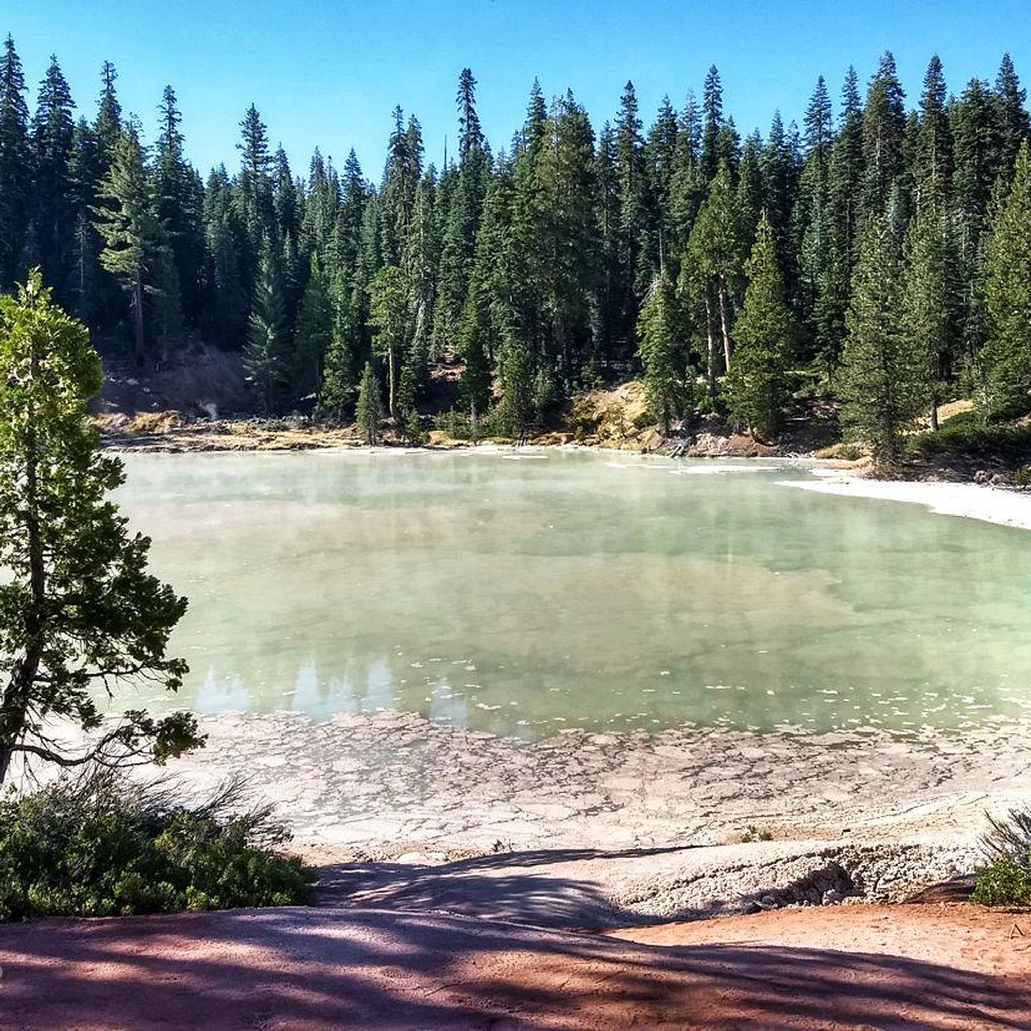
Cold Boiling Lake is a lesser hydrothermal area diminishing in activity. Bubbles can still be seen near the shore.
0
0
This viewpoint overlooks a great portion of the geothermal activity occurring in the Bumpass Hell area. Steaming vents and boiling pools are visible.
0
0
This is a year-round visitor center located near the park's southwest entrance. Amenities include wifi, gift shop, dining, exhibits, and information desk. Directions, hours of operation, and more can be found at the visitor center website: https://www.nps.gov/lavo/planyourvisit/visitorcenters.htm
0
0
Frequently Asked Questions
What is the best time of year for hiking in Lassen Volcanic Wilderness?
The main hiking season typically runs from June through October. Due to the park's high elevation, many trails can remain covered in snow well into June or even July. For the best access to the entire trail network, plan your visit for late summer, from August to September.
Are there any easy, family-friendly hikes in the area?
Yes, the region offers several gentler trails suitable for families. A great option is the Terrace, Shadow, and Cliff Lakes Trail. It's a relatively short walk that leads you past a series of beautiful alpine lakes without a major climb.
Where can I see waterfalls or lakes?
The wilderness is dotted with numerous lakes and streams. For a challenging hike that rewards you with a tour of many water features, consider the North Lakes Loop, which passes by Summit, Echo, Twin, and several other lakes.
Are there trails to see the park's famous hydrothermal features?
Absolutely. Hiking is the best way to experience the park's geothermal wonders. Many trails lead to areas like Bumpass Hell, Devil's Kitchen, and Boiling Springs Lake, where you can see bubbling mud pots, steam vents, and boiling water.
Do I need a permit for day hiking?
No, permits are not required for day hiking in Lassen Volcanic National Park. However, a park entrance fee is required. Permits are necessary for any overnight backcountry camping. For the most current regulations, it's always best to check the official park website.
What are the trail conditions like?
Trail conditions vary greatly depending on the season and elevation. Lower elevation trails are usually clear of snow by June, but higher peaks like Lassen Peak can hold snow until late July. Always check the latest trail status on the official Lassen Volcanic National Park website before you go.
How difficult is parking at popular trailheads?
Parking at popular trailheads, such as the one for Lassen Peak, can be very challenging, especially on weekends and holidays. The lots often fill up early in the day, so it's recommended to arrive in the morning to secure a spot.
Can I bring my dog on the trails?
Pets are not permitted on any hiking trails, in the backcountry, or in hydrothermal areas within Lassen Volcanic National Park. They are allowed only in developed areas like campgrounds and parking lots, and must be on a leash at all times.
Are there any good loop hikes available?
Yes, there are several excellent loop hikes. For a moderate day out that takes you past multiple lakes, the Sifford and Bench Lakes Loop is a fantastic choice, offering a varied landscape without having to retrace your steps.
What do other hikers think of the trails in Lassen Volcanic Wilderness?
The trails are highly regarded by the komoot community, with an average rating of 4.7 stars. Hikers frequently praise the unique volcanic landscapes, the stunning alpine lakes, and the sense of solitude found on many of the routes.
How many hiking trails are in the region?
There are around 50 curated hiking routes in Lassen Volcanic Wilderness available on komoot, covering over 150 miles of official trails. These range from short, easy nature walks to strenuous, multi-day backpacking adventures.
What should I know about backcountry camping?
Backcountry camping offers a true wilderness experience but requires a permit, which must be obtained in advance. You'll also need to use a bear-resistant canister for food storage. For detailed rules and permit information, visit the park's wilderness page.
Most popular attractions in Lassen Volcanic Wilderness

Get inspired with the komoot mobile app


Explore more
Browse the best Hikes in other regions.
