The best walks and hikes in Pond Mountain Wilderness
5.0
(16)
173
hikers
11
hikes
Hikes in Pond Mountain Wilderness explore the rugged terrain of the Cherokee National Forest in northeastern Tennessee. The region is characterized by steep forested slopes, the deep Laurel Fork Gorge, and several creeks that carve through the landscape. Many routes follow sections of the Appalachian Trail, leading to natural features like Laurel Falls.
Best hiking trails in Pond Mountain Wilderness
- The most popular hiking route is Laurel Falls via Hampton Blueline Trail — Pond Mountain Wilderness, a 4.7 mile (7.5 km) trail that takes about 2 hours 5 minutes to complete. This moderate hike follows the blue-blazed trail to the 55-foot cascade of Laurel Falls.
- Another top favourite among local hiking enthusiasts is Appalachian Trail: Dennis Cove to Laurel Falls — Pond Mountain Wilderness, an easy 2.4 mile (3.8 km) path. The trail follows a scenic section of the Appalachian Trail along Laurel Fork creek.
- Local hiking enthusiasts also love the Appalachian Trail: Shook Branch Beach to Watauga Dam — Cherokee National Forest, a 5.6 mile (9.0 km) trail leading through the national forest, often completed in about 2 hours 25 minutes.
- Hiking in Pond Mountain Wilderness is defined by its rugged gorges, upland hardwood forests, and cascading waterfalls. The trail network offers both easy creekside walks and more moderate routes with some elevation gain.
- The routes in Pond Mountain Wilderness are highly rated by the komoot community with an average score of 4.9 stars from over 10 reviews. More than 100 hikers have used komoot to explore Pond Mountain Wilderness's varied terrain.
Last updated: July 16, 2026
20
hikers
39.3km
11:45
1,270m
1,180m
The Appalachian Trail: Dennis Cove to US 19E offers a diverse and demanding journey through the Cherokee National Forest, winding through lush hardwood forests and along Laurel Fork Creek. You'll encounter picturesque cascades, including the impressive 55-foot Laurel Falls, and be treated to panoramic views of Watauga Lake from various viewpoints. The route also famously crosses directly over the historic Watauga Dam, blending wilderness with a touch of human ingenuity.
This is a difficult hiking route, covering 24.4 miles (39.3 km) with a substantial 4169 feet (1271 metres) of elevation gain, typically taking around 11 hours and 45 minutes. Be prepared for steep ascents, particularly up Pond Mountain, and varied terrain. Parking is available at both the Dennis Cove and US 19E trailheads, but always check conditions, especially for creek crossings, which can be tricky during high water.
Beyond the stunning natural beauty, this section of the AT is rich in natural features and history. You'll pass through the remote Pond Mountain Wilderness and utilize old railroad beds in some sections, adding a historical dimension to your hike. The area is also known for its abundant wildlife, including sightings of orange salamanders and various fungi, making it a truly immersive experience for nature lovers.
13
hikers
14.2km
04:36
550m
710m
This section of the Appalachian Trail from Dennis Cove to Watauga Lake offers a dynamic hiking experience, winding through lush hardwood forests and vibrant rhododendron thickets. You'll encounter rocky sections and switchbacks, especially on the ascent of Pond Mountain, before being rewarded with panoramic views of Watauga Lake and the surrounding mountains. A highlight is the impressive Laurel Falls, a 50-foot waterfall that provides a refreshing stop along the way.
Planning your visit means preparing for a moderate 8.8-mile (14.2 km) hike with a significant 1800 feet (549 metres) of elevation gain, which typically takes around 4 hours and 36 minutes. The trail is accessible from Dennis Cove, where tent sites are available, and near Watauga Lake, the USFS Shook Branch Recreation Area offers amenities like picnic tables and water during warmer months. Be sure to check creek conditions, as some crossings can be challenging after heavy rains.
What makes this route particularly notable is its journey through both the Pond Mountain Wilderness and the Big Laurel Branch Wilderness, offering a true sense of solitude. The trail famously crosses directly over the historic Watauga Dam, providing a unique perspective of this engineering marvel. This segment is a fantastic choice for those seeking a challenging day hike with diverse scenery, from dense forest tunnels to expansive lake vistas.

Sign up for free
7
hikers
3.77km
01:02
100m
0m
The Laurel Falls Trail offers a delightful, easy hike through lush forest to a stunning 80-foot, two-tiered waterfall. You'll follow a paved path, though it can be uneven in spots, winding past abundant mountain laurel and rhododendron before reaching the iconic falls, where a footbridge allows you to cross over the middle section. This 2.3-mile (3.8 km) route with 319 feet (97 metres) of elevation gain typically takes just over an hour, making it a rewarding experience for nearly everyone.
Given its popularity, the best time to visit Laurel Falls Trail is early in the morning, late in the evening, on a weekday, or during the off-season to avoid heavy crowds. Be aware that the trail will be closed for 18 months starting January 6, 2025, for extensive rehabilitation work, so check current conditions before you go. This closure will impact how long Laurel Falls Trail takes to hike and its accessibility.
As one of only a few paved trails in the Great Smoky Mountains National Park, Laurel Falls Trail is notably accessible, though its uneven surface means it's not suitable for all strollers. Historically, it served as an access route for fire crews. Keep an eye out for wildlife, as bears are known to inhabit the area, and remember that the mountain laurel blooms in May, adding vibrant color to the journey.
4
hikers
1.90km
00:33
10m
100m
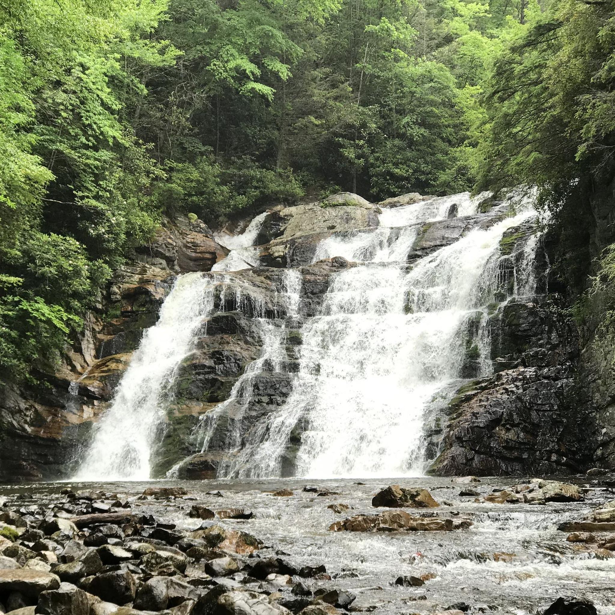
The Laurel Falls via Appalachian Trail offers a delightful journey through the Cherokee National Forest, tracing the Laurel Fork Creek. You'll wander through dense forests and rhododendron thickets, with the path occasionally following an old railroad bed before joining the famed Appalachian Trail. The highlight is undoubtedly the majestic 55-foot Laurel Falls, a stunning block waterfall dramatically set between cliffs, providing a picturesque reward for your efforts.
This easy hiking route is a quick adventure, covering 1.2 miles (1.9 km) with a minimal 38 feet (12 metres) of elevation gain, typically taking just 33 minutes. While much of the trail is gentle, be aware that the final descent to the falls involves a series of rock steps that can be steep, so good footwear is recommended. Access is usually from the Dennis Cove area, offering a more primitive experience than other regional trails.
What makes this trail particularly notable is its location within the Pond Mountain Wilderness, providing a rugged and less developed feel. Unlike the paved Laurel Falls Trail in Great Smoky Mountains National Park, this route offers a traditional hiking experience, often with fewer crowds. It's a fantastic option for those looking for a beautiful waterfall and a taste of the Appalachian Trail in northeast Tennessee.
1
hikers
4.62km
01:17
90m
90m
The Appalachian Trail from Oliver Hollow Road to Watauga Dam offers a delightful journey through hardwood forests, where mountain laurel and rhododendron thickets add splashes of color. You'll enjoy tranquil water views of Watauga Lake as the path skirts its edge, leading to the truly unique experience of walking across the Watauga Dam. This easy 2.9-mile (4.6 km) hike, with only 289 feet (88 metres) of elevation gain, is a fantastic way to experience a piece of the AT in about 1 hour and 17 minutes.
Planning your visit should include checking for any temporary reroutes, which can occur due to high lake levels or wildlife activity like bears. While specific parking information for the Oliver Hollow Road trailhead isn't detailed, this segment is generally accessible. It's a great option for a quick, rewarding outing, especially if you're looking for an easy hike with big views.
This section of the Appalachian Trail is particularly notable for its dramatic crossing of the Watauga Dam, a 331-foot tall earthen structure that offers expansive views of Watauga Lake on one side and a significant drop to the Watauga River gorge on the other. Completed in 1948, the dam is historically significant as the highest elevation earthen dam in the eastern United States, blending natural beauty with impressive human engineering.
Get access to more routes and recommendations from other explorers.
Sign up for free
Already have an account?
Our route recommendations are based on thousands of hikes, rides, and runs completed by other people on komoot.
Start today with a free account
Your next adventure awaits.
Login or Signup
Popular around Pond Mountain Wilderness

Tips from the Community

US-19E is one of the most convenient access points to the Appalachian Trail near Roan Mountain. The road connects directly to both Roan Mountain, TN, and Elk Park, NC, it is a good spot to start, end, or resupply a section hike. Parking is available at the trailhead, but it’s best to coordinate with a shuttle if you’re leaving your car for more than a day. You can book with Roan Mountain Shuttle directly on their website: roanmountainshuttle.setmore.com.
0
0


The Appalachian Trail passes right over the top of Watauga Dam and looks over Watauga Lake. With the Pond Mountain Wilderness to the south and the Big Laurel Branch Wilderness to the north, this is a wild and secluded part of the AT. Once you get away from the boaters at the marina, you'll have a lot of solitude in either direction.
0
0
The Appalachian Trail passes right over the top of Watauga Dam and looks over Watauga Lake. With the Pond Mountain Wilderness to the south and the Big Laurel Branch Wilderness to the north, this is a wild and secluded part of the AT. Once you get away from the boaters at the marina, you'll have a lot of solitude in either direction.
0
0
The Appalachian Trail passes right over the top of Watauga Dam and looks over Watauga Lake. With the Pond Mountain Wilderness to the south and the Big Laurel Branch Wilderness to the north, this is a wild and secluded part of the AT. Once you get away from the boaters at the marina, you'll have a lot of solitude in either direction.
0
0
This bridge crosses over the Laurel Fork waterway, which gets pretty full in the spring and summer months. You actually have to cross the water a handful of times between here and Laurel Falls.
0
0
Laurel Falls is a really popular hiking destination. You can get there by taking the Appalachian Trail from Dennis Cove or by starting over in Hampton on the Blueline Trail. Note while out here that the white blazes on the trees and rocks are for the Appalachian Trail and the blue blazes are for the Blueline Trail. There is a super steep set of rock stairs for the final 200 meters down to the water. Be prepared to get in a workout once you leave the falls area!
0
0
Frequently Asked Questions
Are dogs allowed in Pond Mountain Wilderness?
Yes, dogs are generally permitted on trails in the Pond Mountain Wilderness and Cherokee National Forest, but they must be kept on a leash and under your control at all times. Please be sure to pack out any waste to help preserve the natural environment.
What is the terrain like in Pond Mountain Wilderness?
The terrain is known for being rugged and challenging. Expect steep forested slopes, with some inclines exceeding 60 degrees. Many trails descend into the deep Laurel Fork Gorge, which features impressive cliffs and rocky sections along the creek.
Are there any easy hikes suitable for beginners or families?
Yes, there are several easier options. A great choice is the Appalachian Trail: Dennis Cove to Laurel Falls. It's a relatively flat 2.4-mile (3.8 km) walk that follows the scenic Laurel Fork creek, making it accessible for most skill levels.
Which trail is best for seeing waterfalls?
For a spectacular waterfall view, the Laurel Falls via Hampton Blueline Trail is your best bet. This moderate hike leads directly to the base of the stunning 55-foot Laurel Falls, a major highlight of the wilderness area.
Are there any circular or loop hikes available?
Yes, you can find loop trails in the area. The Appalachian Trail & Coon Den Falls Trail loop offers a varied 3.5-mile (5.7 km) circuit through the Cherokee National Forest, combining different trail experiences into one hike.
What should I pack for a day hike in this area?
Given the rugged terrain, sturdy hiking boots with good grip are essential. Always carry plenty of water, snacks, and a map, as cell service can be unreliable. We also recommend packing rain gear, as weather can change quickly in the mountains, and insect repellent during warmer months.
Where can I find parking for the trails?
Parking is available at various trailheads. For trails originating near Dennis Cove, there are designated parking areas. Roadside parking can also be found on TN-321/US-67 near the Watauga Lake swimming area for access to the Appalachian Trail. Arrive early on weekends as spots can fill up.
What kind of wildlife might I see?
The diverse forests support a variety of wildlife. It's common to see deer, grouse, and wild turkeys. The area is also home to a healthy black bear population, so it's important to be bear-aware, store food properly, and know what to do if you encounter one.
Are there opportunities for backpacking and camping?
Yes, backpacking is a popular activity, with a 6.6-mile section of the Appalachian Trail crossing the wilderness. An AT shelter is located within the Laurel Fork Gorge for thru-hikers and backpackers. Dispersed camping is permitted according to Cherokee National Forest regulations, but be sure to follow Leave No Trace principles.
Which trail offers good views of the area's cliffs?
The Watauga Scenic Area, located in the heart of the wilderness, is known for its impressive upright cliffs and rock outcroppings. The 2.2-mile Watauga Scenic Trail leads you into this area, providing a chance to see these unique geological features up close.
What do other hikers think of the trails in Pond Mountain Wilderness?
The trails are highly regarded by the komoot community, with an average rating of 4.9 stars. Hikers frequently praise the stunning natural beauty, especially the dramatic Laurel Fork Gorge and the powerful Laurel Falls. The well-maintained sections of the Appalachian Trail are also a consistent favorite.
Is there a short trail for a quick walk with nice scenery?
For a very short and scenic walk, consider the Cardens Bluff Trail loop. It's just over a mile long and offers lovely views, making it perfect if you're short on time but still want to experience the beauty of the Cherokee National Forest.
Most popular routes in Pond Mountain Wilderness

Get inspired with the komoot mobile app


Explore more
Browse the best Hikes in other regions.
