The best walks and hikes in Beerwah State Forest
4.8
(202)
2,219
hikers
23
hikes
Hiking trails in Beerwah State Forest traverse a landscape characterized by extensive pine plantations, native eucalypt forests, and areas around natural waterways like the Mooloolah River and Ewan Maddock Dam. The terrain generally features gentle undulations, with some routes offering moderate elevation changes. This region provides a network of paths suitable for various outdoor activities within a managed forest environment.
Best hiking trails in Beerwah State Forest
- The most popular hiking route is Ewan Maddock Dam Beach loop from Mooloolah River, a 4.7 miles (7.5 km) trail that takes about 1 hour 57 minutes to complete, offering views of the dam and surrounding bushland.
- Another top favourite among local hikers is Hiking loop from Landsborough, a moderate 5.3 miles (8.5 km) path. This route winds through varied forest types, including pine and native woodlands, with some gentle climbs.
- Local hikers also love the Hiking loop from Mooloolah (Marie Higgs) Conservation Park, a 4.9 miles (7.9 km) trail leading through native bushland and conservation areas, often completed in about 2 hours 18 minutes.
- Hiking in Beerwah State Forest is defined by its mix of managed pine forests, native eucalypt woodlands, and proximity to waterways, offering a range of experiences from flat, easy trails to more moderately challenging loops. The network provides options for different ability levels, including family friendly walks in Beerwah State Forest.
- The routes in Beerwah State Forest are highly rated by the komoot community with an average score of 4.6 stars from over 150 reviews. More than 2000 hikers have used komoot to explore Beerwah State Forest's varied terrain.
Last updated: July 17, 2026
5.0
(1)
22
hikers
8.24km
02:08
40m
40m
Moderate hike. Good fitness required. Easily-accessible paths. Suitable for all skill levels.
5.0
(1)
17
hikers
12.2km
03:10
80m
80m
Moderate hike. Good fitness required. Easily-accessible paths. Suitable for all skill levels.

Sign up for free
5.0
(1)
14
hikers
8.49km
02:25
200m
200m
Moderate hike. Good fitness required. Easily-accessible paths. Suitable for all skill levels.
5.0
(2)
32
hikers
2.12km
00:57
160m
160m
Moderate hike. Great for any fitness level. Mostly accessible paths. Sure-footedness required.
5.0
(1)
12
hikers
7.88km
02:18
210m
210m
Moderate hike. Good fitness required. Easily-accessible paths. Suitable for all skill levels.
Get access to more routes and recommendations from other explorers.
Sign up for free
Already have an account?
Our route recommendations are based on thousands of hikes, rides, and runs completed by other people on komoot.
Start today with a free account
Your next adventure awaits.
Login or Signup
Tips from the Community

Brown Loop branches away from the Main Track into a quieter section of forest around Ewen Maddock Dam. After rain, lower sections can become muddy or hold water for short periods.
0
0
Pink Loop is a shorter circuit branching from the Main Track near the northern foreshore of Ewen Maddock Dam. The trail follows a relatively easy route through bushland and lakeside vegetation, with a mix of compacted dirt and gravel surfaces underfoot.
0
0
Tallowwood Track is a shorter walking-only path branching from the main Ewen Maddock Dam track network near Maddock Park. The route begins from a boardwalk beside the water before continuing through lakeside vegetation lined with tallowwood, paperbark, melaleuca, and eucalypt trees. Compared to the wider multi-use Main Track, this section feels quieter and more enclosed, with softer ground underfoot and more shade along the route. The track was recently upgraded following major wet-season damage, including resurfacing and drainage improvements.
0
0

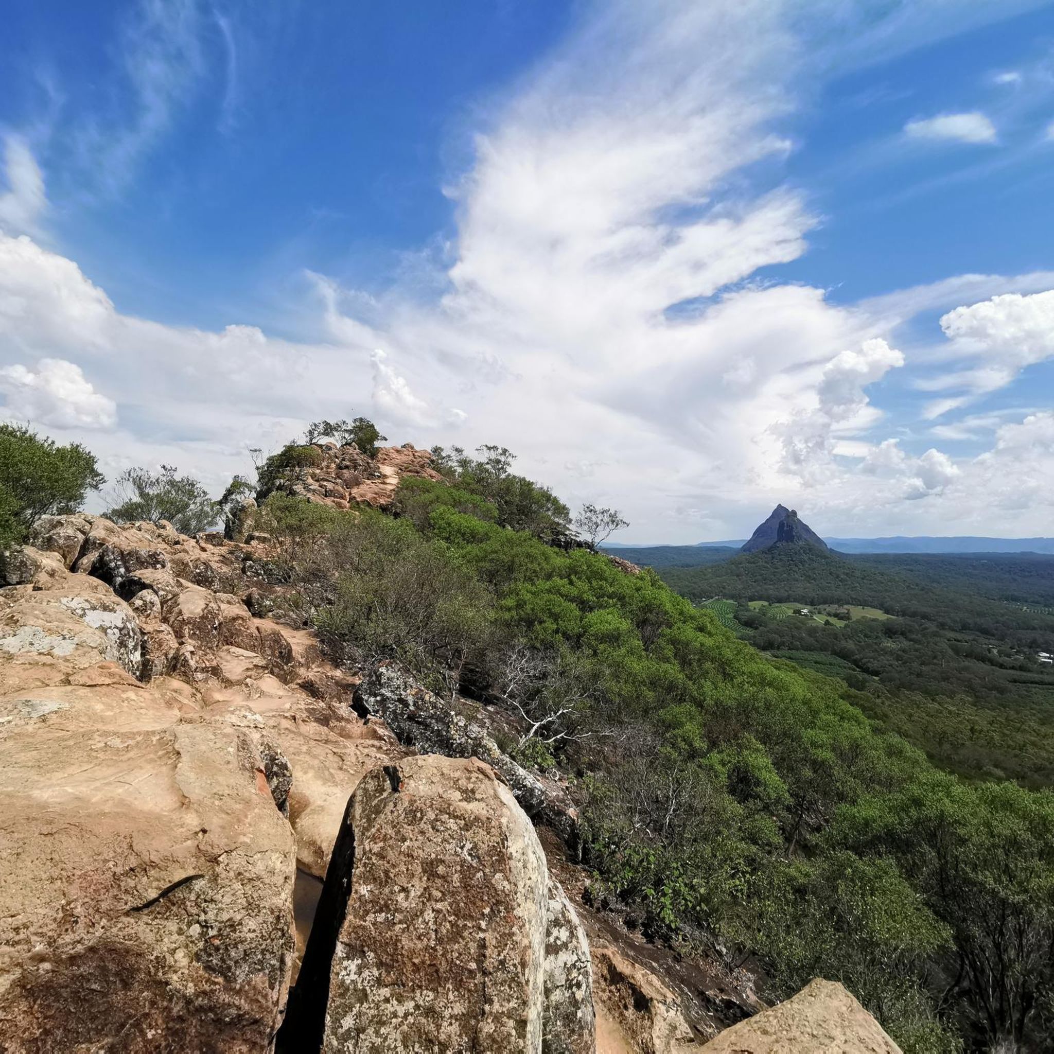
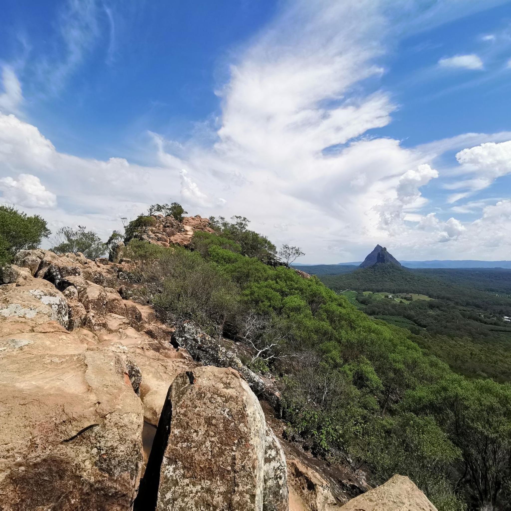
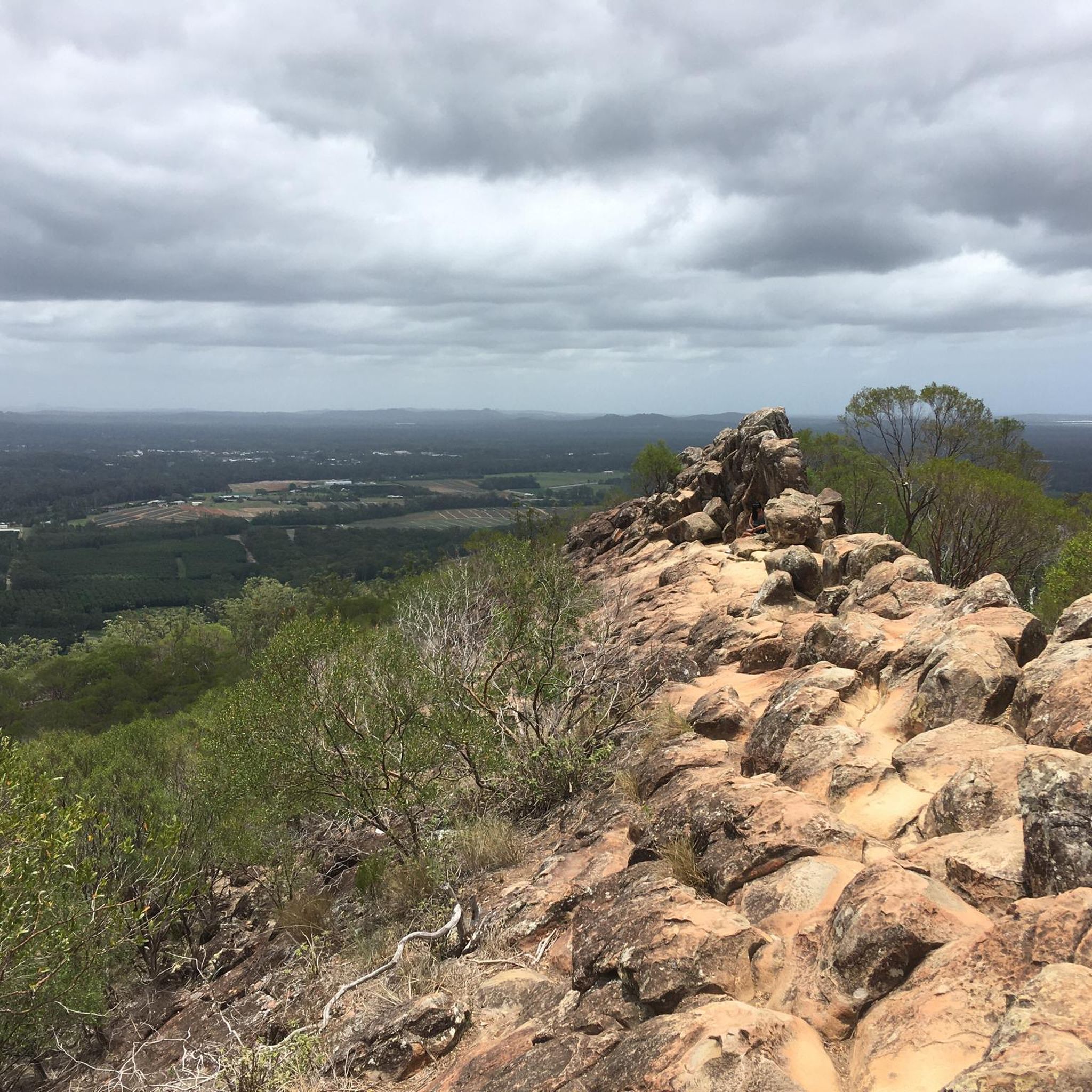
Mount Coochin trail is a short but varied walk that connects the mountain’s twin peaks via a narrow saddle. It’s a faint, often unmarked path that climbs steadily through open forest to the first summit, then drops into a steep gully before a more rugged ascent, sometimes involving light scrambling, up to the second peak. The route is easy to lose in places and requires care on the descent, so having your offline komoot GPS route handy is a good idea to stay on course. The short navigation is well worth the effort, where you can enjoy beautiful sweeping views across the Glass House Mountains from both summits.
0
0
The East Peak is the more open and exposed summit of Mount Coochin, featuring a rocky outcrop that provides wider, more expansive views across Glass House Mountains National Park and out toward the coastal plain. Reached via a steep descent and climb through the saddle, the summit offers fantastic long-distance views over the western peak, making it the primary vantage point of the twin peaks. The terrain near the top is rugged with light scrambling, but it is rewarding, with wide panoramas over the surrounding volcanic peaks and lowlands.
0
0
The West Peak of Mt. Coochin is a rocky, partially enclosed summit within Glass House Mountains National Park, where scattered boulders and low vegetation frame the view toward the East Peak and surrounding ranges. From the top, the view is beautiful, with the ridge leading across to the second summit, where you can see the steep saddle and the route between the two peaks.
0
0
This trailhead is a small, unsealed gravel area located off 2672 Old Gympie Road (Beerwah) and serves as the primary, albeit limited, access point for the Mt. Coochin Twin Peaks trail. Access involves driving up a residential-looking driveway to a gate with a National Park sign, so it’s a good idea to use GPS to be sure you are in the right spot. The Mount Coochin Twin Peaks route begins with a rough fire track that quickly leads into the forest, then splits toward the East and West peaks. The East Peak track is generally open; however, the West Peak section, which forms part of the informal loop, is periodically closed due to Phytophthora disease management. Access can change at short notice, and signage is often not updated, so it’s best to check current conditions and alerts via the Queensland Parks and Wildlife Service before setting out: https://parks.qld.gov.au/parks/glass-house-mountains
0
0

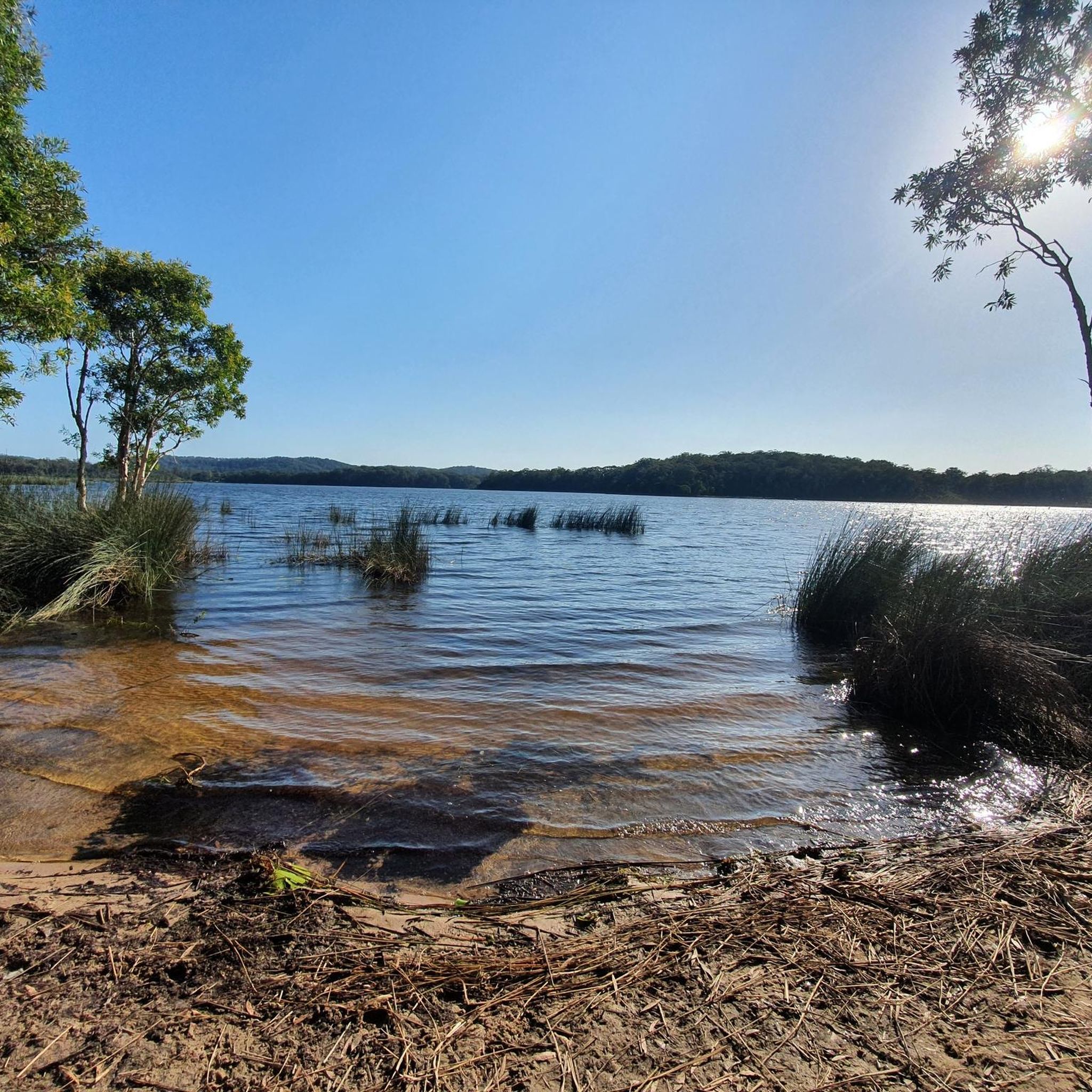
Beach area at Ewan Maddock Dam. Swimming is allowed. There is also a parking lot nearby, some public toilets as well as swings and a playground. You can also have access to free public BBQs and picnic tables.
0
0
Frequently Asked Questions
How difficult are the hiking trails in Beerwah State Forest?
Beerwah State Forest offers a range of trails, with 11 routes rated as easy and 8 as moderate. There are no difficult trails listed, making it accessible for most fitness levels. The terrain generally features gentle undulations through pine plantations and native eucalypt forests.
Are there family-friendly walks in Beerwah State Forest?
Yes, Beerwah State Forest has several family-friendly options. Many of the easy-rated trails are suitable for families. For example, the Mount Ngungun Summit Track, though outside the immediate forest, is an easy 2.5 km hike that offers rewarding views and is popular with families.
Are dogs allowed on the hiking trails in Beerwah State Forest?
Dogs are generally permitted in Queensland State Forests, including Beerwah State Forest, but must be kept on a leash at all times. Always ensure you clean up after your pet to help preserve the natural environment.
What is the best time of year to go hiking in Beerwah State Forest?
The best time to visit Beerwah State Forest for hiking is during the cooler, drier months, typically from April to October. This avoids the intense summer heat and humidity, as well as the higher rainfall of the wet season, making for more comfortable conditions on the trails.
Are there any cafes or facilities near the hiking trails?
Within Beerwah State Forest itself, facilities are generally limited to basic amenities like parking areas. For cafes, restaurants, and more extensive facilities, you would need to visit nearby towns such as Beerwah or Landsborough, which are a short drive away.
Can I find circular hiking routes in Beerwah State Forest?
Yes, Beerwah State Forest features several excellent circular routes. Popular options include the Ewan Maddock Dam Beach loop from Mooloolah River, which offers views of the dam, and the Hiking loop from Mooloolah (Marie Higgs) Conservation Park, winding through native bushland.
How long are the typical walks in Beerwah State Forest?
The walks in Beerwah State Forest vary in length, but many popular routes range from 4.7 miles (7.5 km) to 5.3 miles (8.5 km), typically taking between 1 hour 57 minutes and 2 hours 30 minutes to complete. There are also shorter options available for quicker excursions.
What should I pack for a hike in Beerwah State Forest?
For hiking in Beerwah State Forest, it's advisable to pack plenty of water, sun protection (hat, sunscreen), insect repellent, sturdy closed-toe shoes, and a first-aid kit. Depending on the season, a light rain jacket might also be useful. Always carry a charged phone and inform someone of your plans.
Are there any less-trafficked trails for a quieter experience?
While some trails, like those around Ewan Maddock Dam, can be popular, Beerwah State Forest's extensive network of paths through pine and eucalypt woodlands often allows for quieter sections. Exploring some of the less-advertised tracks, or visiting during off-peak times, can provide a more solitary experience.
What do other hikers say about Beerwah State Forest?
The komoot community highly rates Beerwah State Forest, with an average score of 4.6 stars from over 180 reviews. Hikers often praise the well-maintained trails, the peaceful atmosphere of the forest, and the variety of scenery, from dense pine plantations to native bushland and dam views.
Is Beerwah State Forest accessible by public transport?
Direct public transport access to the trailheads within Beerwah State Forest is generally limited. While nearby towns like Beerwah and Landsborough have train stations (on the Sunshine Coast Line), reaching specific hiking starting points usually requires a car or a short taxi/rideshare service from the station.
Are there any unique geological features to see in the forest?
Beerwah State Forest itself is primarily characterized by its diverse forest types and waterways. While the dramatic Glass House Mountains, which are volcanic plugs, are a prominent geological feature in the broader region, the state forest's trails offer views of these mountains rather than direct access to their unique rock formations.
Most popular routes in Beerwah State Forest

Get inspired with the komoot mobile app


Explore more
Browse the best Hikes in other regions.
