The best running trails in Bowditch-Runnels State Forest
24
runners
7
runs
Jogging in Bowditch-Runnels State Forest offers an experience through diverse natural landscapes, characterized by dense woodlands, winding trails, and the presence of crystal-clear ponds and streams. Joggers will encounter forested paths with moderate elevation changes, leading towards notable features like Bald Mountain and the base of Mount Chocorua. This environment provides a variety of natural, unpaved surfaces suitable for trail running. The extensive trail network makes Bowditch-Runnels State Forest an ideal location for outdoor pursuits.
Best jogging routes in Bowditch-Runnels…
Last updated: July 12, 2026
4
runners
9.48km
01:29
540m
540m
Hard run. Very good fitness required. Mostly paved surfaces. Suitable for all skill levels.
7
runners
Hard run. Very good fitness required. Mostly paved surfaces. Suitable for all skill levels.

Sign up for free
6
runners
6.65km
01:06
410m
410m
Hard run. Very good fitness required. Mostly paved surfaces. Suitable for all skill levels.
11.2km
01:31
350m
350m
Hard run. Very good fitness required. Mostly paved surfaces. Suitable for all skill levels.
10.3km
01:33
610m
610m
Hard run. Very good fitness required. Mostly paved surfaces. Suitable for all skill levels.
Get access to more routes and recommendations from other explorers.
Sign up for free
Already have an account?
Our route recommendations are based on thousands of hikes, rides, and runs completed by other people on komoot.
Start today with a free account
Your next adventure awaits.
Login or Signup


Tips from the Community

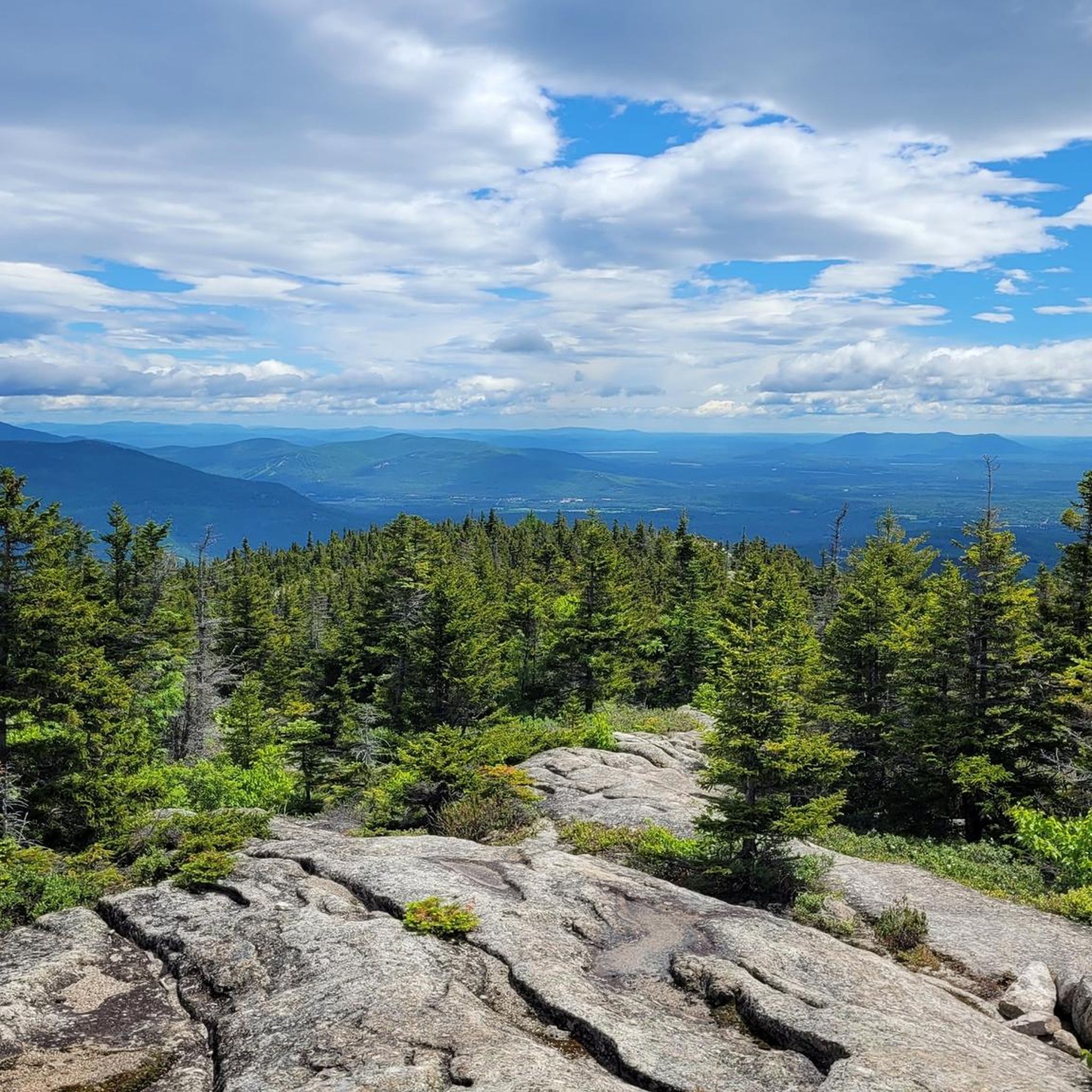
Along this section of the Piper Trail leading to the summit, you'll reach the mountain saddle between the Three Sisters and Mount Chocorua. The well-marked path crosses smooth granite rocks with ease, offering stunning views that stretch southward and northeast across the White Mountains.
1
0

At the mountain saddle between the 'Three Sisters' and 'Mount Chocurua', follow the 'Piper Trail' up to the summit. The marked route leads over bare granite rocks without any difficulties. The fantastic view extends to the south and northeast over the 'White Mountains'.
2
1
Mount Chocorua is named after the Sokosis chief Chocorua, who lived in the early 18th century. The 1,064 m high Mount Chocorua is one of the most frequently climbed mountains in the US state of New Hampshire. The Appalachian Mountain Club notes that Mount Chocorua is one of the most photographed mountains in the world. https://www.chocorualake.org/hike-chocorua The striking mountain is the easternmost peak of the Sandwich Range and lies at the southern end of the White Mountains. The rocky peak is the result of a series of forest fires between the early 19th and 20th centuries. From its summit there are excellent views of the surrounding mountains and forests. The mountain is part of the almost 25 sq. km. large protected area ‘Mount Chocorua Scenic Area‘, which was created in 1986 as part of the ‘White Mountain Forest Plan‘. https://www.fs.usda.gov/Internet/FSE_DOCUMENTS/stelprdb5364479.pdf
2
0

The White Ledge is a 2,000-foot high peak in the White Mountain National Forest. It can be reached via the 4.4 mile long White Ledge Trail loop and offers stunning views of the surrounding mountains and valleys. At the trailhead you can find a parking lot and campground.
0
0

Heron Pond, also known as Lonely Lake, is an eight-acre kettle hole in Frank Bolles Nature Reserve. There are several trails in the park that take you to the pond.
1
0

Mount Chocorua is a 3,490-foot summit in New Hampshire and is one of the most popular peaks in the whole state. The most popular approach involves climbing over 2,000 feet, so it's a pretty tough run, but the terrain isn't terrible, so the downhill back to the car is a rush.
0
0
Mount Paugus South Peak is part of the larger Mount Paugus in the Sandwich Range of the White Mountains. After a forested and rocky ascent, you are rewarded with impressive views of the surrounding landscape, including nearby peaks and valleys.
0
0

You are standing at the top of Chocorua Mountain. Its easily identifiable summit is famous for its beauty but also for its legend: It takes its name from a short story by the author Lydia Maria Child which tells the legend of an Indian chief named Chocorua. In the fiction, Chocorua dies at the top of this mountain after cursing the white settlers responsible for the destruction of its culture and its people. Is it from a true story or completely fictionalized? No one really knows. This legend is now part of New Hampshire history and is featured on a state historical marker (number 31), along Route 16 in Tamworth.
1
0
Frequently Asked Questions
How many running trails are available in Bowditch-Runnels State Forest?
Bowditch-Runnels State Forest offers 9 dedicated running trails. These routes provide diverse experiences through dense woodlands and varied terrain, primarily featuring challenging options for experienced runners.
What is the typical difficulty level for running routes in Bowditch-Runnels State Forest?
Most running routes in Bowditch-Runnels State Forest are considered difficult, with 8 out of 9 trails falling into this category. These often involve significant elevation changes and forested paths. There is one moderate option available for those seeking a slightly less strenuous run.
What kind of terrain can I expect on the jogging trails in Bowditch-Runnels State Forest?
The jogging trails in Bowditch-Runnels State Forest are characterized by natural, unpaved surfaces. You'll encounter forested paths winding through dense woodlands, often with moderate to significant elevation changes as you approach features like Bald Mountain and Mount Chocorua.
Are there any notable landmarks or scenic viewpoints along the running routes?
Yes, the forest features prominent natural landmarks. Many trails lead towards or offer views of Bald Mountain and Mount Chocorua. For example, the Summit lookout loop from Tamworth specifically offers mountain views as it ascends towards a summit lookout.
Are there any circular running routes in Bowditch-Runnels State Forest?
Yes, there are several circular running routes available. An example is the White Ledge loop from Albany, which is a 4.1-mile (6.6 km) trail leading through forested paths.
What is the best time of year to go running in Bowditch-Runnels State Forest?
While the forest is beautiful year-round, autumn is particularly scenic due to the stunning fall foliage, transforming the landscape with vibrant colors. The diverse ecosystems and natural features make it an appealing destination throughout the warmer months as well.
Are the running trails in Bowditch-Runnels State Forest suitable for families?
The majority of routes in Bowditch-Runnels State Forest are rated as difficult, involving significant elevation and natural, unpaved terrain. While there is one moderate option, families with younger children or those seeking very easy, flat paths might find these trails challenging. It's best to check individual route details for suitability.
What do other runners enjoy most about jogging in Bowditch-Runnels State Forest?
Runners often praise the immersive forest experience, with trails winding through towering trees and the tranquility provided by crystal-clear ponds and glistening streams. The challenge of the varied terrain and the rewarding mountain views from higher elevations are also frequently highlighted.
Can I bring my dog on the running trails?
While the region research doesn't specify a dog policy, state forests in New Hampshire generally allow leashed dogs on trails. However, it's always recommended to check the specific regulations for Bowditch-Runnels State Forest or any particular trail before heading out with your pet.
Are there any long-distance running options available?
Yes, for those looking for longer runs, the forest offers routes like the Lovejoy Wildlife Preserve – Mount Chocorua Scenic Area loop from Albany, which spans 19.5 km (12.1 miles) and involves significant elevation gain, providing a challenging endurance experience.
What kind of natural features will I encounter while running?
You'll experience a rich natural environment including dense woodlands, crystal-clear ponds, and glistening streams. The terrain also features forested paths with moderate elevation changes, leading to mountain views and notable points like Bald Mountain and the base of Mount Chocorua.
Is there parking available for accessing the running trails?
While specific parking locations are not detailed in the guide, access points for trails like the Bald Mountain Loop from Chocorua Lake and Mount Chocorua Summit Loop from Tamworth suggest that parking facilities are available near popular trailheads. It's advisable to check local resources for precise parking information before your visit.
Most popular routes in Bowditch-Runnels State Forest

Get inspired with the komoot mobile app


Explore more
Browse the best Running Trails & Routes in other regions.
