The best running trails around Halfway
264
runners
27
runs
Jogging routes Halfway provide access to diverse terrain, from the deep canyons of Hells Canyon to the expansive Wallowa-Whitman National Forest. The region is characterized by picturesque Pine Valley, offering a mix of rugged natural landscapes and serene backdrops. Runners can explore trails along the Snake River and experience the mountainous backdrop of the Southern Wallowas.
Best jogging routes around Halfway
- The most popular jogging route is View of the Weir – Wire Heron Sculpture loop from Cambuslang, a…
Last updated: July 5, 2026
39
runners
8.09km
00:51
50m
50m
Moderate run. Good fitness required. Mostly paved surfaces. Suitable for all skill levels.
14
runners
12.6km
01:20
80m
80m
Moderate run. Good fitness required. Mostly paved surfaces. Suitable for all skill levels.

Sign up for free
9
runners
5.57km
00:35
50m
50m
Moderate run. Good fitness required. Mostly paved surfaces. Suitable for all skill levels.
9
runners
8.39km
00:53
70m
70m
Moderate run. Good fitness required. Mostly paved surfaces. Suitable for all skill levels.
11
runners
10.8km
01:08
70m
70m
Moderate run. Good fitness required. Mostly paved surfaces. Suitable for all skill levels.
Get access to more routes and recommendations from other explorers.
Sign up for free
Already have an account?
Our route recommendations are based on thousands of hikes, rides, and runs completed by other people on komoot.
Start today with a free account
Your next adventure awaits.
Login or Signup

Tips from the Community

The Orion Bridge in Cambuslang was built to connect Cambuslang to Tollcross. It was designed by Crouch and Hogg and features steel lattice trusses supported by masonry piers. It was initially linked to the nearby Clydebridge Steel Works. Though bypassed in the 1970s due to increasing traffic loads, it still serves local traffic today.
1
0

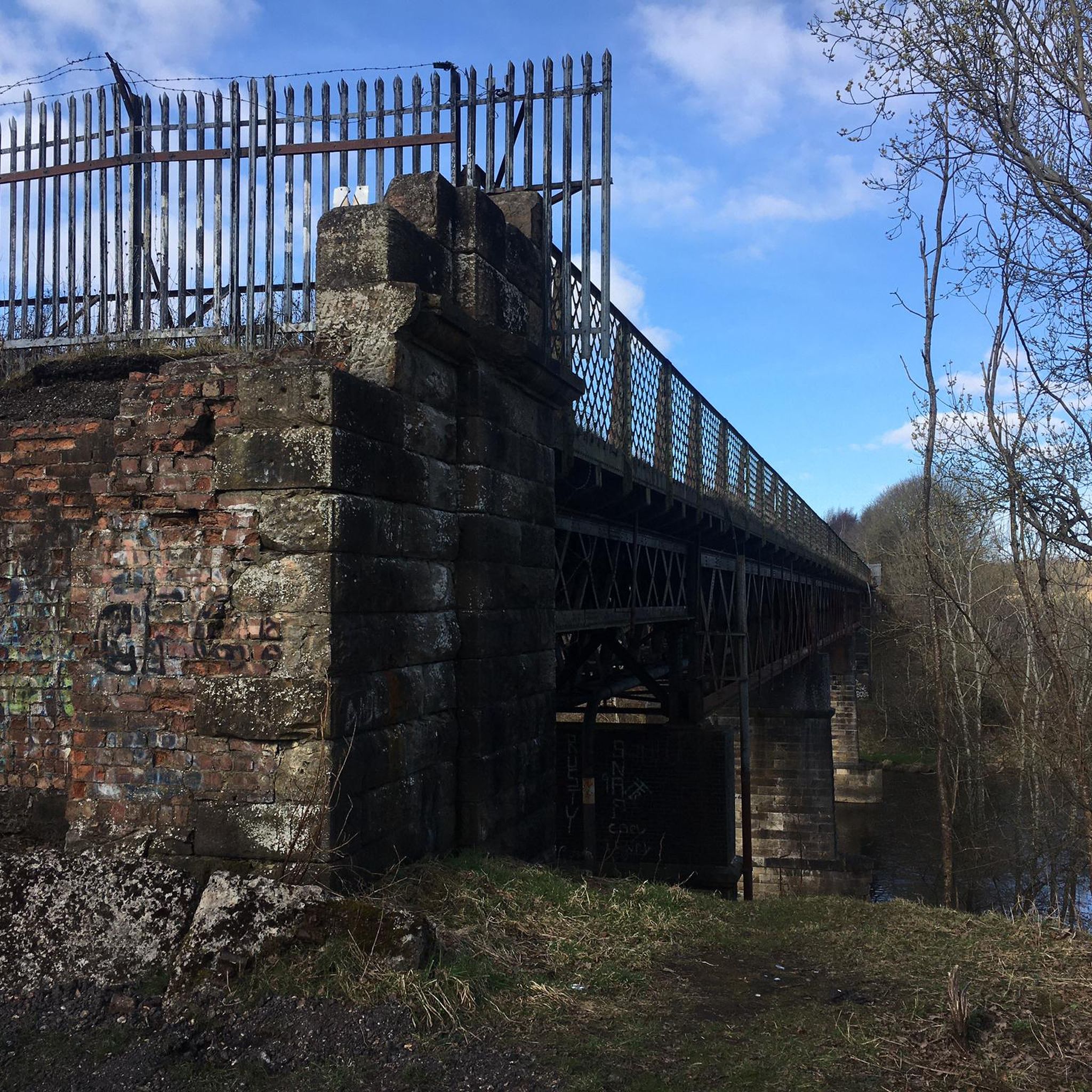
Westburn Viaduct, also known as Carmyle Viaduct, is a disused railway bridge over the River Clyde between Carmyle in Glasgow (north side) and Westburn (Cambuslang) in South Lanarkshire (south side). It is constructed of a steel lattice frame with sandstone pillars and has three main spans over the water. The bridge was constructed in 1897 as part of the Glasgow Central Railway between Carmyle and Newton stations and linked to the Rutherglen and Coatbridge Railway. Fencing blocking off the bridge from the south bank (before the most recent effective fortifications were added) A further connection towards Kirkhill on the Lanarkshire and Ayrshire Railway was made in 1904. The passenger train services using the bridge ended in 1964, although freight services, mostly serving Clydebridge Steelworks and Clyde Iron Works, continued until 1983 when those facilities ceased operating. The bridge was officially closed and fenced-off, although for some years it was still accessible to pedestrians determined enough to overcome the barriers. After gang disorder involving youths from Westburn and Carmyle escalated into serious violence in 2012, the barriers were further reinforced to prevent the bridge being used by the youths to approach their rivals’ territory. Between 2013 and 2015 a project to add illumination to the bridge developed with input by pupils from local schools (Bannerman HS, Trinity HS and Cathkin HS) in an effort to build bonds between the communities on either side of the bridge. In early 2021, Sustrans Scotland announced a project to refurbish the bridge as a walking and cycling route across the river, inviting consultation from locals (with some residents on both sides objecting to the plans due to the recent history of violence associated with the route being accessible to rival youths).
1
0

Frequently Asked Questions
How many running routes are available around Halfway?
There are over 20 dedicated jogging routes around Halfway, offering a diverse range of experiences. These trails vary in difficulty, from easy paths suitable for a relaxed jog to more challenging routes for experienced runners, all set against the stunning backdrop of the Pine Valley and surrounding natural areas.
What kind of terrain can I expect on jogging routes near Halfway?
Jogging routes near Halfway offer a remarkable variety of terrain. You can find everything from serene paths through the picturesque Pine Valley and local streets to rugged trails with dramatic canyon views in Hells Canyon. The expansive Wallowa-Whitman National Forest provides diverse landscapes, including alpine peaks and grasslands, while the Wallowa Mountains offer challenging high-altitude single-track routes. Some trails also feature views along the Snake River.
Are there running trails suitable for beginners or those looking for an easy jog?
Yes, Halfway offers several easy jogging routes perfect for beginners or those seeking a more relaxed pace. There are 5 routes classified as easy, providing gentle inclines and scenic views. The 3.7-mile View of the Weir – Wire Heron Sculpture loop from Cambuslang is a great example of a moderate route that is accessible for various fitness levels, offering pleasant local waterways and sculptures.
Are there any longer or more challenging running routes for experienced runners?
Absolutely. For experienced runners seeking a challenge, Halfway provides routes with significant elevation gain and rugged terrain. The region boasts 2 difficult routes and 15 moderate routes. The Hells Canyon National Recreation Area, for instance, offers adventurous jogs with dramatic canyon views. The Wallowa Mountains also provide high-altitude single-track routes, particularly enjoyable between July and October when wildflowers are in bloom.
What natural features or landmarks can I see along the jogging routes?
The jogging routes around Halfway are rich with natural beauty and interesting landmarks. You can explore areas with stunning canyon views in Hells Canyon, vast forests in the Wallowa-Whitman National Forest, and the serene landscapes of Pine Valley. While jogging, you might encounter highlights such as Linn Park Waterfall, or enjoy views of Strathclyde Loch and Lochend Loch. Some routes also pass by unique features like the Cadzow Oaks or the Glasgow Green.
Are there any circular running routes available?
Yes, many of the jogging routes around Halfway are circular, allowing you to start and finish at the same point. For example, the View of the Weir – Orion Bridge, Cambuslang loop from Newton is a moderate 6.2-mile circular path featuring river views. Another option is the 18% Climb loop from Newton, a 3.4-mile trail through varied local terrain.
What is the best time of year to go jogging in Halfway?
Halfway offers great jogging opportunities year-round, but the best time often depends on your preference for terrain and weather. The Wallowa-Whitman National Forest is a year-round playground. For high-altitude single-track routes in the Wallowa Mountains, July to October is ideal when snow has melted and wildflowers are in bloom. Always check local weather conditions before heading out, especially during winter months.
Are there any family-friendly running trails in Halfway?
Yes, Halfway has several routes that are suitable for families. The easier trails, often found within Pine Valley or along local streets, provide a safe and enjoyable environment for all ages. These routes typically have less elevation gain and are shorter in distance, making them perfect for a family outing.
Are dogs allowed on the jogging routes around Halfway?
Many outdoor areas around Halfway, including trails within the Wallowa-Whitman National Forest and local paths, are generally dog-friendly. However, it's always recommended to check specific trail regulations before you go, as rules can vary, especially in protected areas like Hells Canyon National Recreation Area. Always keep your dog on a leash and clean up after them to ensure a pleasant experience for everyone.
Are there any jogging routes that offer views of water bodies?
Yes, several jogging routes in Halfway provide scenic views of water bodies. The region is close to the Snake River, offering trails along its banks. Additionally, some routes feature local waterways, such as the View of the Weir – Wire Heron Sculpture loop from Cambuslang. You can also find routes near lakes like Strathclyde Loch and Lochend Loch.
Where can I find information about parking or public transport for these running trails?
The city of Halfway is actively working on improving trail and trailhead infrastructure, which includes enhancing accessibility and wayfinding. While specific parking details for each trail might vary, many trailheads offer designated parking areas. For public transport options, it's best to consult local Halfway transportation services or visit the official Halfway tourism website at visithalfwayoregon.com for up-to-date information on reaching trail access points.
What makes Halfway a unique destination for jogging?
Halfway stands out as a jogging destination due to its unique combination of diverse and dramatic landscapes. Runners can experience the profound depths of Hells Canyon, the vast wilderness of the Wallowa-Whitman National Forest, and the serene beauty of Pine Valley, all within close proximity. This blend of challenging terrain and picturesque scenery, from river views to alpine backdrops, offers an unparalleled variety of running experiences.
Most popular attractions around Halfway

Get inspired with the komoot mobile app


Explore more
Browse the best Running Trails & Routes in other regions.
