The best walks and hikes in Escuintla
4.8
(91)
3,282
hikers
12
hikes
Hiking in Escuintla offers trails primarily characterized by volcanic terrain and significant elevation changes. The region is dominated by prominent stratovolcanoes, including Volcán de Acatenango and Volcán de Fuego, which shape the landscape. Hikers can expect routes that ascend through varied ecosystems, from lower slopes to higher, more exposed volcanic environments. The trails often provide expansive views of the surrounding mountainous areas.
Best hiking trails in Escuintla
- The most popular hiking route is Summit of Volcán de Acatenango – Acatenango…
Last updated: July 5, 2026
4.8
(19)
731
hikers
12.8km
07:20
1,340m
1,340m
Hard hike. Very good fitness required. Sure-footedness, sturdy shoes and alpine experience required.
4.8
(16)
772
hikers
Hard hike. Good fitness required. Sure-footedness, sturdy shoes and alpine experience required.

Sign up for free
4.8
(19)
320
hikers
13.2km
08:02
1,550m
1,550m
Hard hike. Very good fitness required. Sure-footedness, sturdy shoes and alpine experience required.
4.0
(4)
272
hikers
5.23km
03:20
610m
610m
Hard hike. Good fitness required. Sure-footedness, sturdy shoes and alpine experience required.
4.5
(4)
241
hikers
2.63km
01:30
370m
360m
Moderate hike. Good fitness required. Easily-accessible paths. Suitable for all skill levels.
5.0
(1)
96
hikers
Hard hike. Good fitness required. Sure-footedness, sturdy shoes and alpine experience required.
4.8
(20)
694
hikers
13.2km
06:56
1,150m
1,150m
Hard hike. Very good fitness required. Mostly accessible paths. Sure-footedness required.
5.0
(4)
36
hikers
13.3km
08:00
1,540m
1,540m
Hard hike. Very good fitness required. Sure-footedness, sturdy shoes and alpine experience required.
5.0
(1)
27
hikers
Hard hike. Good fitness required. Sure-footedness, sturdy shoes and alpine experience required.
4
hikers
19.8km
11:38
2,270m
2,270m
Hard hike. Very good fitness required. Sure-footedness, sturdy shoes and alpine experience required.
Get access to more routes and recommendations from other explorers.
Sign up for free
Already have an account?
Our route recommendations are based on thousands of hikes, rides, and runs completed by other people on komoot.
Start today with a free account
Your next adventure awaits.
Login or Signup
Popular around Escuintla
Tips from the Community


hike without any difficulty, just a little more elevation after a big climb before but worth the detour
0
0
Perfect place to sleep! A few places to put up the tent and admire the view without being in the boxes with everyone else.
1
0

Just self-guided Acatenango with three friends (overnight). We didn't find much of the critical information out there but we think there is some stuff you should know before self-guiding it. It's too much for this comment so check out the comments I posted on my completed hike: https://www.komoot.es/tour/1968201751?ref=aso (If that link doesn't lead you anywhere, check under my completed trails for the Acatenango one of november 2024.)
2
1

For the evening and night, it is definitely advisable to bring warm clothing and gloves, as it gets very cold at night at this altitude. In exposed places like the summit, it can also be quite windy.
3
0
The eruptions occur every few minutes and usually last only a few seconds.
2
0
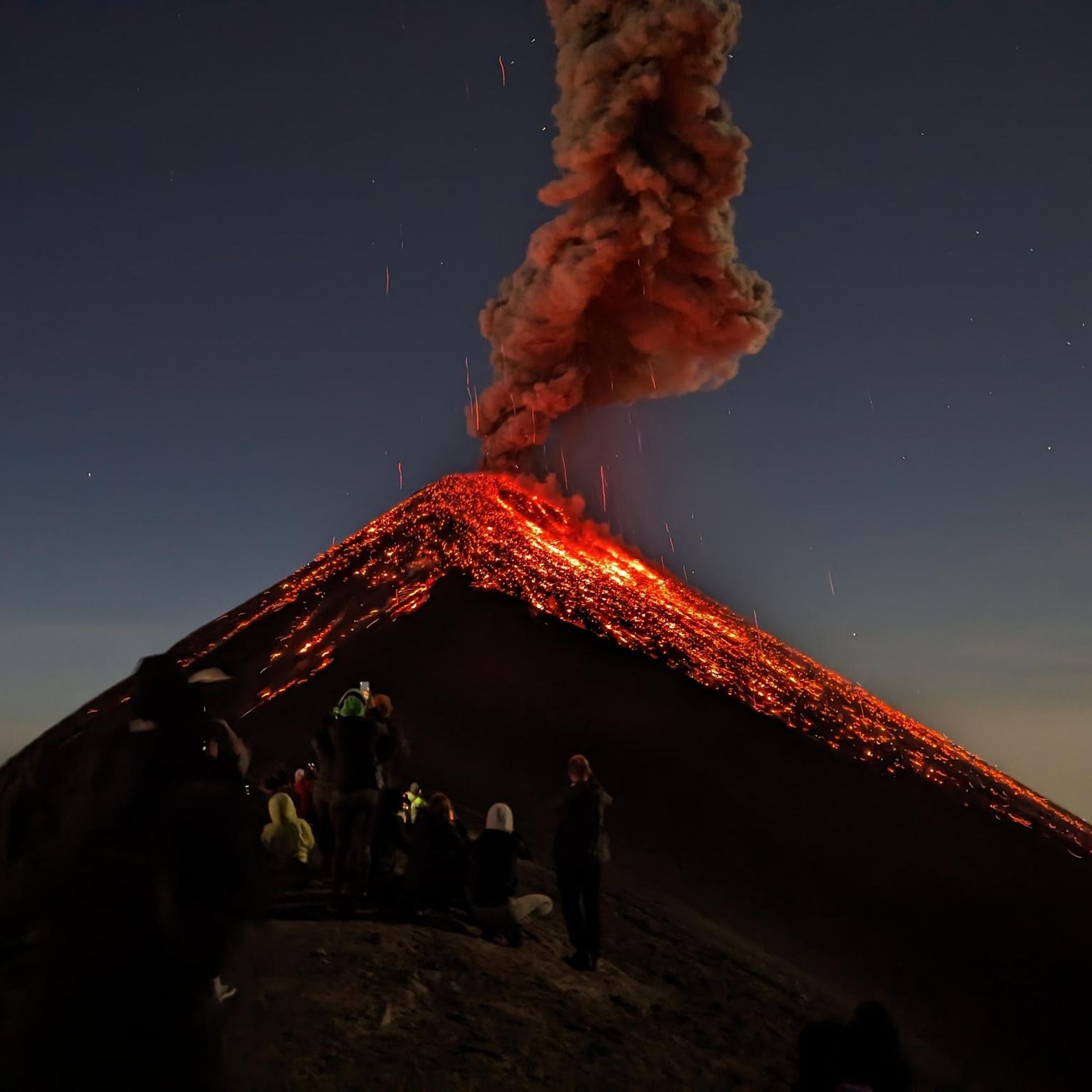
If you stand on the slope of Fuego and look across to Acatenango, you can see several "campamentos" on its flanks. At night, the eruptions of Fuego are even more spectacular because you can see the glowing red lava fountains.
3
0

The 2-day tour on the Acatenango is quite exhausting but a unique experience. During the day you can see the ash clouds and at night the spraying lava. Don't go too fast on the hike up, the thin air at almost 4,000 meters shouldn't be underestimated.
2
1
Frequently Asked Questions
Are there any easy or beginner-friendly hikes in Escuintla?
Hiking in Escuintla is primarily characterized by challenging ascents of volcanic peaks. While most routes are difficult, there is one moderate trail available: Summit of Volcán de Acatenango loop from Acatenango. This 1.6-mile (2.6 km) trail offers a taste of the volcanic landscapes without the extreme difficulty of other routes.
What is the typical duration for hikes in Escuintla?
Hikes in Escuintla vary significantly in length and duration due to the substantial elevation changes on volcanic terrain. For example, the moderate Summit of Volcán de Acatenango loop from Acatenango can be completed in about 1 hour 28 minutes. However, more challenging routes like Summit of Volcán de Acatenango – Acatenango Base Camps loop from Miratenango typically take around 7 hours 10 minutes, and the most demanding trails can extend to over 11 hours, such as Volcán de Fuego – Acatenango Base Camps loop from la Soledad.
Do I need a permit or a guide to hike the volcanoes in Escuintla?
For safety and logistical reasons, especially when hiking prominent volcanoes like Acatenango and Fuego, it is highly recommended to go with an experienced local guide. While specific permits might not always be required for entry to the general area, organized tours often handle any necessary fees or permissions. Guides also provide crucial support for navigation, safety, and understanding the volcanic environment.
When is the best time of year to go hiking in Escuintla?
The best time to hike in Escuintla is generally during the dry season, which typically runs from November to April. During these months, you can expect clearer skies, less rain, and better visibility for panoramic views of the volcanoes and surrounding landscapes. The wet season (May to October) can bring afternoon showers, making trails muddy and views obscured by clouds.
What should I wear and bring for hiking in Escuintla's volcanic terrain?
Given the significant elevation changes and volcanic environments, layered clothing is essential. Temperatures can vary greatly from the base to the summit. Bring sturdy hiking boots with good ankle support, waterproof and windproof outer layers, warm clothing (even in warmer months), a hat, gloves, and plenty of water. Sun protection, a headlamp, and snacks are also highly recommended.
Are there any circular hiking routes in Escuintla?
Yes, many of the popular hiking routes in Escuintla are designed as loops, allowing you to experience varied scenery without retracing your steps. Examples include the Summit of Volcán de Acatenango – Acatenango Base Camps loop from Miratenango and the Fuego Volcano Lava Viewpoint – View of Volcán de Fuego loop from Acatenango. These circular routes offer comprehensive exploration of the volcanic landscapes.
What do other hikers enjoy most about hiking in Escuintla?
The hiking experiences in Escuintla are highly rated by the komoot community, with an average score of 4.8 stars. Hikers frequently praise the challenging ascents, the unique volcanic landscapes, and the breathtaking panoramic views of the surrounding mountains and the active Volcán de Fuego. The sense of accomplishment after summiting these peaks is also a common highlight.
Are the hiking trails in Escuintla dog-friendly?
While some trails might be accessible for dogs, the challenging nature of Escuintla's volcanic hikes, with steep ascents, rocky terrain, and high altitudes, may not be suitable for all dogs. It's best to check specific trail regulations and consider your dog's fitness and endurance before bringing them along. Always ensure your dog is on a leash and you carry out all waste.
How many hiking trails are available in Escuintla?
There are over 10 hiking routes available in Escuintla, offering a range of experiences primarily focused on the region's volcanic terrain. The majority of these routes are classified as difficult, catering to experienced hikers seeking significant challenges and rewarding views.
Are there any specific viewpoints for Volcán de Fuego?
Yes, several routes offer incredible views of the active Volcán de Fuego. For instance, the Fuego Volcano Lava Viewpoint – View of Volcán de Fuego loop from Acatenango is specifically designed to provide excellent vantage points. Other trails, such as View of Volcán de Fuego – Summit of Volcán de Acatenango loop from la Soledad, also offer expansive views of Fuego as part of the larger Acatenango ascent.
Are there options for parking at the trailheads in Escuintla?
For popular volcanic hikes like Acatenango, designated parking areas are typically available near the main trailheads, often in villages such as La Soledad or Acatenango. These areas may be managed by local communities or tour operators and might involve a small fee. It's advisable to confirm parking arrangements with your guide or tour provider in advance.
Most popular routes in Escuintla

Get inspired with the komoot mobile app


Didn’t find what you were looking for?
Check out more Hikes throughout Escuintla below and find the perfect route in your destination.
Explore more
Browse the best Hikes in other regions.
