Easy hikes and walks around Sankt Andrä-Höch
4.5
(1553)
8,442
hikers
434
hikes
Easy hiking trails around Sankt Andrä-Höch traverse a landscape characterized by gentle, rolling hills and lush meadows. This region, often referred to as the "Styrian Tuscany," is part of the Naturpark Südsteirisches Weinland, featuring scenic vineyards and a protected natural environment. The terrain includes primeval and slate soils, contributing to its distinct viticulture. The Demmerkogel, at 671 meters, is a prominent hill offering panoramic views across the Sausal wine country.
Best easy hiking trails around Sankt Andrä-Höch
- The most popular…
Last updated: September 30, 2026
4.4
(16)
59
hikers
Easy hike. Great for any fitness level. Easily-accessible paths. Suitable for all skill levels.
4.6
(5)
38
hikers
Easy hike. Great for any fitness level. Easily-accessible paths. Suitable for all skill levels.

4.3
(4)
31
hikers
Easy hike. Great for any fitness level. Easily-accessible paths. Suitable for all skill levels.
4.6
(12)
25
hikers
Easy hike. Great for any fitness level. Easily-accessible paths. Suitable for all skill levels.
5.0
(4)
33
hikers
Easy hike. Great for any fitness level. Easily-accessible paths. Suitable for all skill levels.
Get access to more routes and recommendations from other explorers.
Already have an account?
Our route recommendations are based on thousands of hikes, rides, and runs completed by other people on komoot.
Start today with a free account
Your next adventure awaits.
Popular around Sankt Andrä-Höch
Other adventures around Sankt Andrä-Höch

Tips from the Community

The Demmerkogel is 671 meters high and thus the highest elevation in the Sausal wine region. The view you enjoy from here is correspondingly gigantic.
0
0


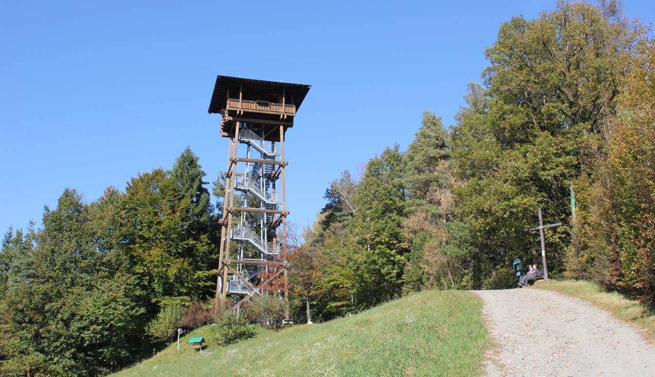
After two lookout towers on the Demmerkogel had already burned down, this magnificent lookout tower was opened in 2023, offering stunning views of the surrounding area and far into Slovenia. A drinks vending machine is located in a hut right next to the lookout tower. Drinking water dispensers and a restroom are located a few meters further down the access road, almost before the final steep section to the lookout tower.
0
0
Before the water runs out on the steep slopes of the vineyards, you can refill your tank here when you visit the lookout point; either with sugary drinks from the rest hut or – a few meters further down the access road – drinking water. There's also a restroom.
0
0

At 23.8m it towers above the tallest trees and offers a wonderful panoramic view as far as Graz in the north or Riegersburg in the east
0
0

Campsite with sauna and whirlpool. Excellent views of the entire western Styria region.
0
0

Great panoramic view, last part to the Demmelkogel lookout only on foot
0
0

The labyrinth in the forest is part of the trail “The Great Adventure on the Demmerkogel”: Can you find the way to the other side of the labyrinth?
1
0
Frequently Asked Questions
How many easy hiking trails are available in Sankt Andrä-Höch?
Sankt Andrä-Höch offers a wide selection of easy hiking trails, with over 200 routes specifically graded as easy. This makes the region ideal for leisurely strolls and light hikes through its picturesque landscapes.
What kind of terrain can I expect on easy hikes around Sankt Andrä-Höch?
The easy hiking trails in Sankt Andrä-Höch traverse gentle, rolling hills, lush meadows, and scenic vineyards. The region, often called the 'Styrian Tuscany,' is part of the Naturpark Südsteirisches Weinland, characterized by its unique primeval and slate soils. You'll find well-maintained paths suitable for a relaxed walking experience.
Are there any family-friendly easy hikes in Sankt Andrä-Höch?
Yes, Sankt Andrä-Höch is very family-friendly. Many easy trails are suitable for families, such as 'Das große Abenteuer am Demmerkogel,' an adventure trail on the Demmerkogel featuring interactive stations and leading to the Schmetterlingswiese (Butterfly Meadow). The Schneideranneri Wine Tavern – Theresien Chapel loop is another great option, offering a pleasant 2.8-mile walk.
What are some notable landmarks or viewpoints I can see on easy hikes?
Easy hikes often lead to prominent landmarks and offer stunning views. You can visit the Demmerkogel Observation Tower for panoramic vistas or see the World’s Largest Klapotetz, a traditional wooden wind rattle, on a 2.2-mile loop from Sankt Andrä-Höch. The Demmerkogel itself, at 671 meters, provides breathtaking views of the Sausal wine country.
Are there circular easy hiking routes available?
Yes, many easy routes in Sankt Andrä-Höch are circular, allowing you to start and end at the same point. Examples include the Largest Klapotetz – World’s Largest Klapotetz loop and the Demmerkogel Observation Tower – Largest Klapotetz loop, both offering convenient round trips through the scenic landscape.
What is the best time of year for easy hiking in Sankt Andrä-Höch?
The region is beautiful throughout the warmer months. Spring and autumn are particularly pleasant, with mild temperatures and vibrant colors in the vineyards. Summer also offers excellent hiking conditions, often with opportunities to visit local Buschenschenken along the way.
Can I find places to eat or drink along the easy hiking trails?
Absolutely. The Sausaler Weingebiet is known for its traditional Buschenschenken (wine taverns) which are often located along hiking routes. These offer local culinary delights and wines, providing perfect spots for a break during your hike. For example, the Schneideranneri Wine Tavern loop passes by such establishments.
What do other hikers say about the easy trails in Sankt Andrä-Höch?
The easy trails in Sankt Andrä-Höch are highly regarded by the komoot community, boasting an average rating of 4.5 stars from over 575 reviews. Hikers frequently praise the well-maintained paths, the stunning vineyard views, and the peaceful atmosphere of the rolling hills.
Are there any easy hikes that pass by castles or historical sites?
While the focus is on natural beauty and vineyards, some routes may offer glimpses of historical sites. For example, the region is home to several castles like Schloss Ottersbach and Seggau Castle. While not directly on every easy trail, they are nearby attractions that can be combined with a hike.
How long do easy hikes in Sankt Andrä-Höch typically take?
Easy hikes in Sankt Andrä-Höch vary in length and duration, but many can be completed in a few hours. For instance, the Largest Klapotetz loop is about 2.2 miles (3.6 km) and takes approximately 1 hour 15 minutes, while the Demmerkogel Observation Tower loop is 3.2 miles (5.2 km) and typically takes around 1 hour 38 minutes.
Is public transport available to reach easy hiking trailheads?
Sankt Andrä-Höch is accessible, and while specific public transport details for every trailhead vary, the region is generally well-connected. It's advisable to check local bus schedules, such as those provided by regioMOBIL, for the most convenient access to various starting points for your easy hikes.
Are there any easy trails that feature a red deer enclosure?
Yes, some variations of the St. Andrä-Höcher Runde, which offers easy loops through idyllic landscapes, are known to pass by a red deer enclosure. These routes provide a chance to observe local wildlife in a natural setting.
Most popular routes around Sankt Andrä-Höch
Most popular attractions around Sankt Andrä-Höch

Get inspired with the komoot mobile app


Explore more
Browse the best Hikes in other regions.
