Attractions and Places To See in Arraiján - Top 6
Attractions and places to see in Arraiján, located in Panama Oeste Province, offer a variety of natural beauty and recreational opportunities. The district features rolling hills, waterways, and coastal areas, providing diverse landscapes for exploration. Visitors can find viewpoints, beaches, and significant infrastructure that connects the region. Its proximity to major landmarks makes it a point of interest for those exploring the wider Panama region.
Best attractions and places to see in Arraiján
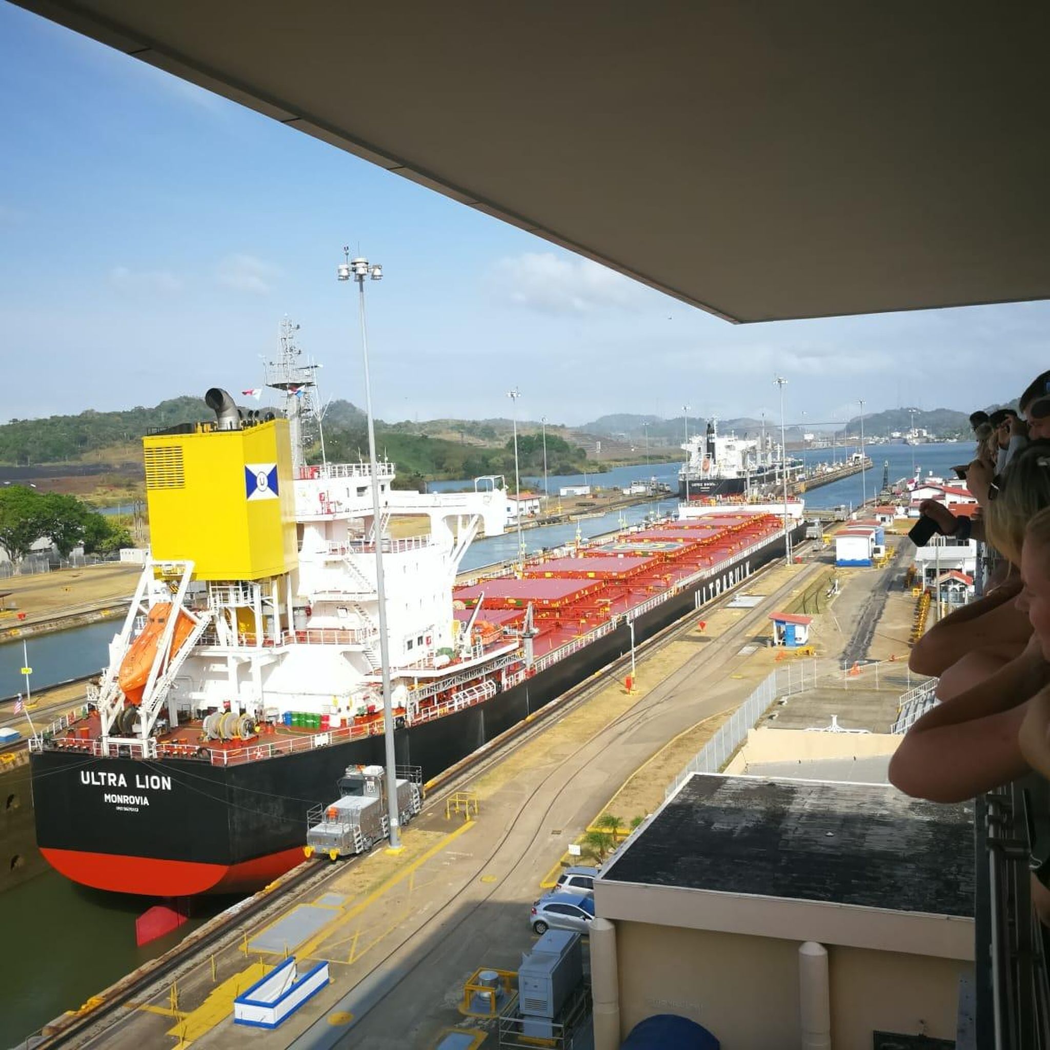
- The most popular attractions is Panama Canal, a man-made monument that is an artificial waterway approximately 82 km long. Its lock chambers are filled and emptied solely by the force of gravity.
- Another must-see spot is Playa Veracruz, a beach. At low tide, the sand along the water is firm, suitable for biking, and a freshwater lagoon empties into the sea nearby.
- Visitors also love Rio Fanfan beach trailhead and dam bridge, a trail that offers views of the Amador causeway and the Panama City skyline. This location provides a crossing point for exploring the beach.
- Arraiján is known for its beaches, viewpoints, and significant man-made structures. The region offers a variety of attractions to see and explore, from coastal areas to historical engineering marvels.
- The attractions in Arraiján are appreciated by the komoot community, with 5 upvotes and 40 photos shared across the highlights.
Last updated: July 15, 2026
Panama Canal
Highlight • Monument
Translated by Google •
Tip by

Bridge of the Americas
Highlight (Segment) • Bridge
It was inaugurated on October 12, 1962, occupying the same location as the ferry it replaced. The United States authorities attempted to name it Thatcher Bridge, but the Panamanian Legislative Assembly decided on the name "Bridge of the Americas," officially designated by resolution of October 2, 1962, because it not only connected Panama's capital city with the interior of the country by land, but also connected the continental landmasses of North and Central America with South America, separated by the Panama Canal. The bridge has a modillion arch design and is 1,654 m long.
Translated by Google •
Tip by

Sign up now to discover places like this
Get recommendations on the best single tracks, peaks, & plenty of other exciting outdoor places.
Sign up for free
Las Américas Overlook and Chinese Memorial
Highlight • Viewpoint
It has been restored and embellished by a Chinese pagoda-style gate and memorials to 150 years of Chinese presence and collaboration with Panama. Snacks and souvenirs are sold near shaded picnic areas.
Access feels a bit dicey via the eastbound access ramp onto the bridge, but if staying on the side it is fairly save to reach the wide shoulder toward the overlook, and onward simoly stay on the sidewalk across the bridge.
Tip by
Locks of the Panama Canal
Highlight • Monument
Translated by Google •
Tip by

Playa Veracruz
Highlight • Beach
Tip by
Rio Fanfan beach trailhead and dam bridge
Highlight • Trail
Tip by
TuriCentro and Veracruz Park
Highlight • Beach
Tip by
Towing Railway
Highlight • Monument
Translated by Google •
Tip by

Start today with a free account
Your next adventure awaits.
Login or Signup


Tips from the Community

The Panama Canal uses a system of three lock complexes to lift ships 26 meters to the level of Gatun Lake and back down. They functioned as water elevators, with ships being pulled into the chambers by locomotives. Since 2016, the larger, modern Neopanamax locks have supplemented the passage. Old locks: Chambers are approx. 304.8 to 327.6 meters long and 33.53 meters wide New locks: Are 427 meters long and 55 meters wide Transit time: A complete passage through the locks and the canal takes about 8 to 10 hours.
0
0
The Panama Canal is an artificial waterway, approximately 82 km long.
2
0
The old Panamax locks use a towpath. Its purpose is to precisely position the ships in the lock chamber and to slow their speed before the lock gates.
2
0
The lock chambers are filled and emptied solely by the force of gravity; there are no pumps. It takes approximately 8 minutes to fill or empty a chamber. Typically, 101,000 cubic meters of water flow in or out of the chamber. The older Panamax locks use a towpath system.
2
0

The Bridge of the Americas is a wheeled vehicle bridge, with a wide shoulder for bicycles and pedestrians, but there are no shoulder ramps, so bicycle access is not very comfortable and appears dangerous due to the shared path with vehicles on both sides. It offers panoramic views of the canal, all the way to Miraflores. It crosses the Panama Canal at its Pacific entrance and connects the towns of Balboa (in Panama City) to the northeast and the district of Arraiján to the southwest. It was inaugurated on October 12, 1962, occupying the same location as the ferry it replaced. The United States authorities attempted to name it Thatcher Bridge, but the Panamanian Legislative Assembly decided on the name "Bridge of the Americas," officially designated by resolution of October 2, 1962, because it not only connected Panama's capital city with the interior of the country by land, but also connected the continental landmasses of North and Central America with South America, separated by the Panama Canal. The bridge has a modillion arch design and is 1,654 m long.
2
0

The Miraflores Locks form the entrance to the canal from the Pacific side. After almost 100 years, they were too small for new container ships, so Panama began building new, supplementary locks after taking over the Canal Zone from the United States. These are located just a little to the west. Feel free to wave to the sailors; they have a lonely job.
1
0
Big overlook terrace with excellent views of the bridge spanning the entrance to the Panama Canal and the huge container ships passing by under the bridge, safely pushed by tugboats. It has been restored and embellished by a Chinese pagoda-style gate and memorials to 150 years of Chinese presence and collaboration with Panama. Snacks and souvenirs are sold near shaded picnic areas. Access feels a bit dicey via the eastbound access ramp onto the bridge, but if staying on the side it is fairly save to reach the wide shoulder toward the overlook, and onward simoly stay on the sidewalk across the bridge.
0
0
The barrage at the mouth of the Fanfan creek into the ocean is a good way to cross while biking along the beach sand, just to explore or camp overnight. It also offers great views of the Amador causeway across to water on the Panama City side of the canal, the city skyline, museums, and the Bridge of the Americas.
0
0
Frequently Asked Questions
What natural features can I explore in Arraiján?
Arraiján is rich in natural beauty, offering rolling hills, valleys, and waterways. You can discover various "chorros" (waterfalls), lush hillsides, and enjoy panoramic views of the Pacific Ocean. Notable natural spots include Playa Veracruz, where a freshwater lagoon empties into the sea, and the area around Rio Fanfan.
Are there hiking trails in Arraiján?
Yes, Arraiján offers several trails suitable for hiking. Rio Fanfan beach trailhead and dam bridge provides a starting point for exploring the beach and offers views of the Panama City skyline. For more options, you can explore various easy hikes in the region, including routes like "Viewpint – Cerro Cedro loop" or "Thorny Tree – Small Shelter in the Forest loop." Find more details on these routes in the Easy hikes in Arraiján guide.
What kind of outdoor activities are available in Arraiján?
Beyond hiking, Arraiján's natural landscape is ideal for biking, bird watching, and kayaking. The district's hills and waterways provide diverse settings for these activities. You can also find road cycling routes, such as the "Cardenas Cycling Meeting Point loop," detailed in the Road Cycling Routes in Arraiján guide.
Where can I find waterfalls in Arraiján?
Arraiján is known for its various "chorros" or waterfalls. A notable tourist spot within the district is the Chorro de Santa Clara, offering a refreshing natural experience.
Are there any mountains or hills for panoramic views in Arraiján?
Yes, Cerro Cabra is a prominent mountain bordering Veracruz and Arraiján cabecera. Standing at 512 meters, it provides a 360-degree view of the surroundings and is a popular spot for hiking. Additionally, the Bridge of the Americas offers panoramic views of the canal and surrounding areas.
What are the notable viewpoints in Arraiján?
Several viewpoints offer stunning vistas. The Bridge of the Americas provides views of the canal and connects the continental landmasses. The Mirador de las Américas, located after crossing the Bridge, offers sights of Cerro Ancón and passing ships. Another excellent spot is the Mirador del Faro near Veracruz, which provides beautiful views of the Bridge of the Americas and nearby vessels.
Can I visit beaches in Arraiján?
Absolutely. Playa Veracruz is a popular beach in Arraiján. At low tide, the sand is firm and suitable for activities like biking. The area also features TuriCentro and Veracruz Park, which is right on the beach and offers facilities like a pool, garden, and shaded picnic tables.
Are there family-friendly attractions in Arraiján?
Yes, Arraiján offers several family-friendly options. Playa Veracruz is great for families, especially at low tide. The TuriCentro and Veracruz Park, located directly on the beach, provides a pool, garden, and picnic areas suitable for families. The Panama Canal, a significant man-made monument, is also considered family-friendly and offers an educational experience.
What is the best time of year to visit Arraiján for outdoor activities?
Panama generally experiences a dry season from December to April and a rainy season from May to November. For outdoor activities like hiking and biking, the dry season typically offers more favorable weather with less rain and more sunshine, making trails more accessible and enjoyable.
What do visitors enjoy most about Arraiján?
Visitors particularly enjoy the diverse natural landscapes, from rolling hills to coastal areas. The opportunity to explore beaches like Playa Veracruz, bike along the firm sand at low tide, and discover hidden spots for camping are highly appreciated. The views of the Panama City skyline and the Bridge of the Americas from various points also receive positive feedback.
Are there running trails in Arraiján?
Yes, Arraiján and its surrounding areas offer several running trails. You can find moderate routes like the "Bosque Urbano Clayton Sur loop" or the "Goethals Monument loop." For more detailed information and route options, refer to the Running Trails in Arraiján guide.
Is there a significant man-made structure to visit in Arraiján?
Yes, the Panama Canal is a major man-made monument that is an artificial waterway approximately 82 km long. Its lock chambers are filled and emptied solely by the force of gravity, making it an engineering marvel. The Bridge of the Americas, connecting the continental landmasses, is another significant structure.

Get inspired with the komoot mobile app


Didn’t find what you were looking for?
Are you keen on exploring more awesome places nearby? Browse our guides:
